This item has been sold, but you can get on the Waitlist to be notified if another example becomes available, or purchase a digital scan.
1932 Clegg Pictorial Map of Virginia, Maryland, and Delaware
VirginiaMaryland-clegg-1932$700.00


Title
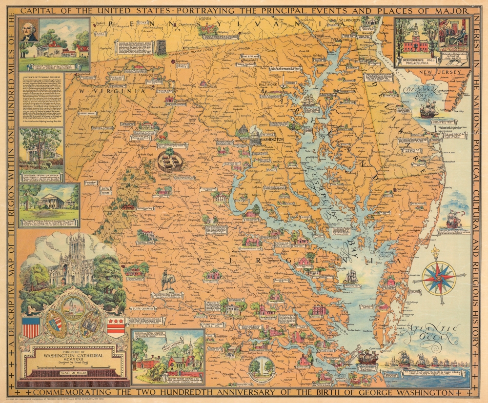
A Descriptive Map of the Region Within One Hundred Miles of the Capital of the United States Portraying the Principal Events and Places of Major Interest in the National Political, Cultural and Religious History Commemorating the Two Hundredth Anniversary of the Birth of George Washington.
1932 (dated) 28.25 x 34 in (71.755 x 86.36 cm) 1 : 500000
1932 (dated) 28.25 x 34 in (71.755 x 86.36 cm) 1 : 500000
Description
This is a 1932 Ernest Clegg pictorial map of Maryland, Delaware, and northern Virginia illustrating the vicinity of Washington, D.C., and the Chesapeake Bay.
A Closer Look
Coverage embraces from Wilmington, Delaware, south to Norfolk, Virginia. The Washington National Cathedral sponsored the publication of this map, and as such, it has a focus on regional churches and religious sites, which are represented pictorially. Other vignettes highlight important historical sites, including the Capital, Arlington National Cemetery, Monticello, the White House of the Confederacy in Richmond, and John Brown's Fort in Harper's Ferry. Crossed cavalry sabers identify American Civil War (1861 - 1865) battlefields, including Gettysburg, Antietam, Bull Run, Shiloh, and The Wilderness. Natural sites also appear, including Shenandoah National Park, mineral springs in West Virginia, and Caledonia State Park in Pennsylvania.The Border Views
Views illustrating historical events adorn the borders. These include Independence Hall, the signing of the Declaration of Independence in Philadelphia, George Washington's home at Mount Vernon, the Rotunda at the University of Virginia, the Capital of Virginia in Richmond, the National Cathedral, William and Mary College, the Washington Monument, and the Revolutionary War French Fleet arriving in the Chesapeake Bay.20th Century Pictorial Cartography
Pictorial qualities have been common in cartography from at least the 16th century when publishers like Braun and Hogenberg incorporated view-like qualities and other pictorial elements into their famous city plans. Braun and Hogenberg, and similar cartographers, issued their town books to express not necessarily the geography of their subjects but rather the 'essence' of the town/city. As mathematics and surveying principles advanced, travel increased, and the ability to translate two-dimensional cartographic perspectives into an understanding of the actual world became commonplace, maps themselves transformed. This trend is a recognizable progression that evolved from the 17th to the 19th centuries. By the late 19th century, most maps had become geographical tools that illustrated the region cartographically but failed in the original raison d'être, as expressed by Braun and Hogenberg, to demonstrate a place's 'essence.' So, where a city map of 19th-century Paris might provide a completely navigable presentation of the city, one could glean almost nothing of Paris' character. In the late 18th century, the first modern 'pictorial' style maps developed. These maps, like Tomas Lopez's 1788 map of Seville, attempted to provide both cartographic accuracy and pictorial elements that might convey the character of the city. In that case, Lopez incorporated pictorial vignettes to illustrate important buildings and monuments. This style became increasingly common throughout the 19th and early 20th centuries, particularly for centers of commerce like London, Paris, and Rome, where they were often mass-produced and referred to as 'monumental' maps. The style further evolved in the early to mid-20th century, when revolutionary cartographers and illustrators like MacDonald Gill, Jo Mora, Frank Dorn, Ernest Dudley Chase, and many others combined vignette style illustrations, modern printing techniques, inspiration from Japanese printmaking and manga and clever satirical cartographers/artists like Fred Rose, to produce maps that once again focused on revealing the essence a place, usually, but not always, at the sacrifice of cartographic precision.Publication History and Census
This map was designed by Ernest Clegg and published by the Washington Cathedral in 1932. Two editions were issued simultaneously. One, the present example, was issued in full color. The other was uncolored, issued in just 200 examples, and intended for hand coloration by Clegg. Four examples of this map are cataloged in OCLC and are part of the collections at the Boston Public Library, Yale University, Harvard University, the Library of Congress, and the Buffalo and Erie County Public Library. Another example, part of the David Rumsey Map Collection, is partially hand-colored, suggesting that Clegg did not get far in his ambition to hand-color all 200 - in fact, we have not identified any examples fully hand-colorized by Clegg.Cartographer
Ernest Clegg (1876 - December 7, 1954) was a British cartographer, graphic artist, and calligrapher. Born in the Birmingham suburbs in 1876, Clegg attended grammar school before gaining acceptance into the Birmingham School of Art. Clegg, who established himself as a specialist calligrapher during these years, was greatly influenced by the Victorian Arts and Crafts Movement and drew inspiration from illuminated manuscripts created during the medieval period. He joined the 7th Dragoon Guards at the outbreak of the Boer War in 1899, and took part in the British advance into the Orange River Colony and Transvaal as part of the 4th Cavalry Brigade in 1900-1901. Clegg was wounded in 1901 and sent back to Britain, and, following his recovery, he enlisted in the newly-formed South African Constabulary. He was posted to the South African Constabulary's sub-divisional headquarters in Harrismith, Transvaal, in 1902. After a year he was transferred to the offices of the District Engineer of Railways in Harrismith, a post he held for six months. Clegg returned to Birmingham in 1905 and went to work for Tiffany in New York as a jewelry designer in 1909. After the outbreak of World War I, Clegg returned to England and received a commission in the 7th (Service) Battalion, known as The Bedfordshire Regiment ("The Shiny 7th"). He served on the Western Front from early 1915 and was promoted to Major in early 1916. While visiting the HMS Revenge, Clegg became the only British Army officer to witness first-hand the pivotal naval Battle of Jutland. He returned to the Front and was badly wounded in a German artillery barrage in late June 1916, just days before the Battle of the Somme. He had recovered and returned to France by early 1917. By the end of the war, however, Clegg had served in several different Home postings, perhaps an indication of physical and psychological scars suffered during his time in France. After his return to the United States in 1919, Clegg became a well-known figure in the American and British veteran community in New York and soon began attracting clients for his work. He illustrated a limited edition of Canadian war poet John McCrae's In Flanders Fields in 1921 and by the mid-20s was gaining recognition for his decorative illustrations and cartographic work. Clegg created a pictorial map of Charles Lindbergh's historic flight across the Atlantic, and also issued maps for the Americas Cup in 1930, 1934, and 1937, which took place off Newport, Rhode Island. Clegg stayed in New York during most of World War II, but returned to England in late 1944, supposedly as a personal favor to the British Ambassador in Washington, Lord Halifax. He soon began working on a series of pictorial maps of English Counties meant to raise money for the Women's Land Army Benevolent Fund. For unknown reasons, possibly due to post-war shortages of paper, the full series of these maps was never published. Clegg's wife, the Australian actress Rita Holden Macdonnell, whom he married in 1911, passed away in 1949. He never fully recovered after her death, and died in a nursing home in Paignton on December 7, 1954. More by this mapmaker...
Condition
Very good. Closed tear extending 1.5 inches into the printed area from right side, repaired on verso. Closed tear extending through upper right corner repaired on verso. Closed minor margin tears repaired on verso.
References
Rumsey 8241.000. OCLC 17328133. Boston Public Library, Leventhal Center, G3791.S1 1932 .C54.