This item has been sold, but you can get on the Waitlist to be notified if another example becomes available, or purchase a digital scan.
1860 Mitchell Map of Virginia (undivided) and North Carolina
VirginiaNorthCarolina-mitchell-1861$100.00

Title
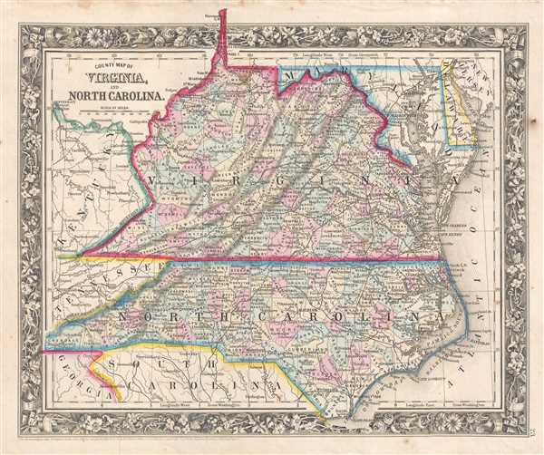
County Map of Virginia, and North Carolina.
1860 (dated) 11.5 x 14 in (29.21 x 35.56 cm) 1 : 2800000
1860 (dated) 11.5 x 14 in (29.21 x 35.56 cm) 1 : 2800000
Description
This is an 1861 Samuel Augustus Mitchell, Jr. map of a unified Virginia with North Carolina, the seat of the Confederacy on the eve of the American Civil War. The map depicts the region from Kentucky, Tennessee, and Georgia to the Atlantic Ocean and from Virginia and Maryland to Georgia, South Carolina, and Cape Fear, North Carolina. Railroads throughout the region are illustrated, through few are labeled. The Orange and Alexandria Railroad is labeled; a railroad that played a critical role during the American Civil War by providing the only direct rail link between the Union capital at Washington, D.C. and the capital of the Confederacy at Richmond. Thus, it was fought over several times throughout the war and saw several battles, including the First Battle of Bull Run, the Battle of Manassas Station Operations, and the Second Battle of Bull Run. Other labeled railroads include the North Western Virginia Railroad and the Baltimore and Ohio Railroad. The Chesapeake and Ohio Canal and the James River Canal are also illustrated and labeled.
Highly detailed, individual counties are illustrated, labeled, and shaded different colors to allow for easy differentiation. Cities, towns, and villages throughout the two states are labeled, along with Washington, D.C., Dover, Annapolis, Knoxville, Wilmington, and other towns in the surrounding states. Rivers are illustrated as well, though only a small portion of them are labeled, along with both the Chesapeake Bay and Delaware Bay.
This map was prepared by S. A. Mitchell Jr. for inclusion in the 1861 edition of Mitchell's New General Atlas. Like many American map publishers of this period, Mitchell did not regularly update his copyrights, consequently this map is dated and copyrighted to 1860: 'Entered according to Act of Congress in the Year 1860 by S. Augustus Mitchell Jr. in the Clerk's Office of the District Court of the U.S. for the Eastern District of Pennsylvania.'
Cartographer
Samuel Augustus Mitchell (March 20, 1792 - December 20, 1868) began his map publishing career in the early 1830s. Mitchell was born in Bristol, Connecticut. He relocated to Philadelphia in 1821. Having worked as a school teacher and a geographical writer, Mitchell was frustrated with the low quality and inaccuracy of school texts of the period. His first maps were an attempt to rectify this problem. In the next 20 years Mitchell would become the most prominent American map publisher of the mid-19th century. Mitchell worked with prominent engravers J. H. Young, H. S. Tanner, and H. N. Burroughs before attaining the full copyright on his maps in 1847. In 1849 Mitchell either partnered with or sold his plates to Thomas, Cowperthwait and Company who continued to publish the Mitchell's Universal Atlas. By about 1856 most of the Mitchell plates and copyrights were acquired by Charles Desilver who continued to publish the maps, many with modified borders and color schemes, until Mitchell's son, Samuel Augustus Mitchell Junior, entered the picture. In 1859, S.A. Mitchell Jr. purchased most of the plates back from Desilver and introduced his own floral motif border. From 1860 on, he published his own editions of the New General Atlas. The younger Mitchell became as prominent as his father, publishing maps and atlases until 1887, when most of the copyrights were again sold and the Mitchell firm closed its doors for the final time. More by this mapmaker...
Source
Mitchell, S. A., Mitchell's New General Atlas Containing Maps of the Various Countries of the World, Plans of Cities, Etc., embraced in Forty-Seven Quarto Maps, Forming a series of Seventy-Six Maps and Plans, together with Valuable Statistical Tables (Philadelphia: S. Augustus Mitchell, Jr.) 1861.
Mitchell's New General Atlas was published by Samuel Augustus Mitchell, Jr., the son of the prolific cartographer Samuel Augustus Mitchell. Many of the plates are derived from the his father's Mitchell's Universal Atlas, but not directly. The Mitchell's Universal Atlas was initially sold to Thomas, Cowperthwait, and Company in 1849, and again to Charles Deliver in 1856. It was Deliver who introduced the new vibrant color scheme, abandoning the older Mitchell's Universal Atlas green borders and themes for bright reds, blues, and yellows. Samuel Augustus Mitchell, Jr. acquired the Deliver plates in 1859. He added his own floral motif border, but doubled down on the vibrant color scheme, thus introducing to the American public the most vividly colored American atlas of the 19th century. In 1860, he published the first edition of his New General Atlas and, despite a slump in sales during the American Civil War, attained a level of success to rival his father. Mitchell would continue to publish the New General Atlas until 1887, when the firm formally closed.
Condition
Very good. Even overall toning. Light soiling and foxing. Blank on verso.
References
Rumsey 0565.015 (1860 edition). Phillips (Atlases) 831-23. Civil War Map Proj. no.: lva00076.