This item has been sold, but you can get on the Waitlist to be notified if another example becomes available, or purchase a digital scan.
1779 Le Rouge American Revolutionary War Map of the Virgin Islands
VirginIslands-lerouge-1779$2,500.00

Title
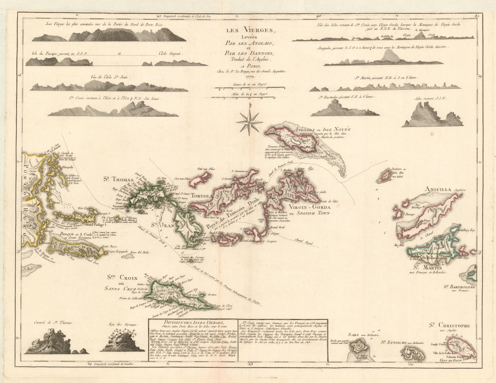
Les Vierges, Levées Par Les Anglais, et Par Les Dannois, Traduit de l'Anglais.
1779 (dated) 19 x 25 in (48.26 x 63.5 cm) 1 : 500000
1779 (dated) 19 x 25 in (48.26 x 63.5 cm) 1 : 500000
Description
A rare 1779 map of the Virgin Islands by Georges-Louis Le Rouge prepared in anticipation of French participation in the American Revolutionary War (1775 - 1783).
Color coding illustrates the complex and shifting colonial claims in the West Indies. Spanish territory is yellow, Danish territory is green, English territory is red, French territory is blue, and Dutch territory, the remains of once vast holdings, appears in light yellow. The map is surrounded by a host of island profile views, which were useful to the mariner and underscore the map's sources, Dutch and English hydrographic surveys.
A Closer Look
The map covers from eastern Puerto Rico to Saint Barts and northern Saint Kitts, embracing both the modern-day U.S. and British Virgin Islands. The map includes the British Virgin Islands, the Danish Virgin Islands (Danish Antilles, or Dansk Vestindien, today's U.S. Virgin Islands), and the Spanish Virgin Islands of Vieques and Culebra, (part of Puerto Rico). Cartographically, it is derived from Thomas Jefferys' map of 1775 but appears to be far rarer - see below.Color coding illustrates the complex and shifting colonial claims in the West Indies. Spanish territory is yellow, Danish territory is green, English territory is red, French territory is blue, and Dutch territory, the remains of once vast holdings, appears in light yellow. The map is surrounded by a host of island profile views, which were useful to the mariner and underscore the map's sources, Dutch and English hydrographic surveys.
Context of the 'Pilote Americain'
In 1778 and 1779, Le Rouge produced his Pilote Americain Septentrional. France had just signed the 1778 'Treaty of Alliance,' formally recognizing the fledgling United States and precipitating a declaration of war from England. Le Rouge's collection of the best maps of the British colonies in the Americas was timely. Virtually all the maps in the Pilote Americain were British, the maps of Jefferys figuring especially prominently. Le Rouge's maps were meticulously and scrupulously faithful to the originals, retaining the English notes and providing French translations.The Scarce Appendix
The complete atlas consisted of three volumes, two of which were issued in 1778, and an appendix volume, hastily assembled and released in 1779. The first volume, focusing on the thirteen colonies, was issued in May 1778. A second volume was issued shortly thereafter, focusing on the northern British colonies in what is today Canada. Both the first and second volumes featured fully engraved title pages. The JCB notes a third volume, lacking a title page and containing just 13 maps focused on the West Indies, published in 1779. This third volume, which was little more than an appendix, was issued in very small quantities, and all 13 of the maps contained within, including the present Virgin Islands map, are exceedingly rare. Some examples have additional maps tipped in, suggesting that all volume 3 maps may have been separate issues.The West Indies, the French, and the American Revolution
It is likely that Le Rouge assembled the West India appendix volume ad-hoc when it became evident that the American Revolution was an opportunity for the French navy to seize wealthy British West Indian colonies. France's navy at first dominated in the West Indies, capturing Dominica, Grenada, Saint Vincent, and Tobago but losing Saint Lucia. After the Siege of Yorktown, the French returned to the West Indies and, by February 1782, were successful in taking Saint Kitts and Montserrat, as well as Demerara and Essequibo in South America. A joint Franco-Spanish invasion of Jamaica was planned but aborted following the decisive British victory at the April 1782 Battle of the Saintes. Although the defeat put French forces on the defensive in the Caribbean, they nonetheless succeeded in capturing Turks and Caicos at the end of the war.Publication History and Census
This map was engraved and published by George-Louis Le Rouge in 1779 based upon the 1775 map of Thomas Jefferys. Despite being derivative, the present map is far rarer than the reasonably common Jefferys map. There are no records of the separate map in the OCLC. The Boston Public Library holds a dissected version. We are aware of one other in private hands. Of the source volume, Pilote Americain Septentrional, we have identified complete editions with the third appendix volume only at the Bibliothèque nationale de France, Yale, and the John Carter Brown Library. From the Brown Library cataloging, we can confirm that Les Vierges was issued in volume 3, the scarce appendix.CartographerS
Georges-Louis Le Rouge (c. 1707 - c. 1790) was a Paris based map publisher operating in the middle part of the 18th century. Le Rouge was born in Hanover Germany as Georg Ludwig, where he was educated and employed as a military engineer and surveyor. His father may have been the French architect Louis Remy de la Fosse (1659 - 1726), which would explain his early education in both engineering and draftsmanship. He assisted his father on a large-scale plan of Darmstadt, which he completed following his father's death in 1726. He may have remained in Darmstadt, but little is known of his life from 1726 - 1736, when he appears in Paris. Le Rouge acquired a position as military and civil engineer for King Louis XV and Louis XVI. Around this time, he Francophied his name to 'Le Rouge'. In 1840, he set up shop on the Rue Des Grands Augustins as an engraver, book publisher, and map publisher. He partnered with the English cartographer and engineer John Rocque (1709 - 1762), who became an important source for English maps, which Le Rouge re-engraved for French use. Despite being born German and adopting Paris as his home, Le Rouge was an ardent Anglophile and spent much of his time translating English books and maps into French. During his active period of roughly forty years Le Rouge produced thousands of maps and diagrams ranging from city and town plans, to atlases, plans of military campaigns and sea charts. He was a friend and correspondent of Benjamin Franklin (1706 - 1790), with whom he produced the important 1769 Franklin/Folger Map of the Gulf Stream. Franklin, who met Le Rouge in Paris, writes that 'He [Le Rouge] is, I believe, a proper person.' He was awarded for his diligence with the impressive but unstipended honorific 'Geographe du Roi'. They may not have served him swell during the French Revolution (1789 - 1799), as his last known work was published in 1789, just before the storming of the Bastille. The exact date of Le Rouge's death remains a mystery. By most estimates, he is believed to have been alive in 1790, but may have lived as long as 1794. More by this mapmaker...
Thomas Jefferys (1695 - November 20, 1771) was one of the most prominent and prolific map publishers and engravers of his day. Jefferys was born in Birmingham and was apprenticed to the engraver Emmanuel Bowen in 1735. Later, in the 1740s he engraved several maps for the popular periodical Gentleman's Magazine. Around 1740 Jefferys was finally able to go into business for himself and in 1746 received an appointment as 'Geographer to Fredrick, Prince of Wales,' which shortly after translated to the position of 'Royal Cartographer to King George III.' Jefferys initially specialized in compiling and re-engraving the works of earlier cartographers into more coherent cartographic wholes. Later, while not salaried position, Jefferys' appointment as 'Royal Cartographer' guaranteed preferential access to the most up to date cartographic material available, allowing him to produce new and updated charts of exceptional accuracy. He his best known for his maps of the Americas, particularly the posthumously published 1775 American Atlas, which included some of the finest and most important late colonial era maps of America ever made. Despite his prolific publishing history, royal appointments, and international publishing fame, Jefferys lived most of his life in dire economic straits. He was bailed out of bankruptcy by Robert Sayer during the production of the American Atlas. In the end, Jefferys died suddenly with very little to his name. Nonetheless, his cartographic legacy survived, and even after his death in 1771, many of his important maps continued to be published and republished by Sayer and Bennet, Conrad Lotter, Georges Louis Le Rouge, Laurie and Whittle, and others. Many attribute some of Jefferys best maps to the colorful and criminally inclined Irish cartographic genius Braddock Mead (John Green, c. 1688 - 1757), who is considered the 'secret behind Jefferys.' Jefferys was succeeded by his son, also Thomas, who had little success as a cartographer and eventually partnered with, then sold his stock and plates to William Faden - Jefferys' true heir. Learn More...
Source
Le Rouge, Georges-Louis, Pilote Americain Septentrional, Volume III, appendix, 1779.
In 1778 and 1779, Le Rouge produced his Pilote Americain Septentrional. France had just signed the 1778 'Treaty of Alliance', formally recognizing the fledgling United States and precipitating a declaration of war from England. Le Rouge's collection of the best maps of the British colonies in the Americas was timely. Virtually all of the maps in the Pilote Americain were British, the maps of Jefferys figuring especially prominently. Le Rouge's maps were meticulously and scrupulously faithful to the originals, retaining the English notes and providing French translations. The complete atlas consisted of three volumes, two of which were issued in 1778, and an appendix volume, hastily assembled and released in 1779. The first volume, focusing on the thirteen colonies, was issued in May of 1778. A second volume was issued shortly thereafter, focusing on the northern British colonies in what is today Canada. Both the first and second volume featured fully engraved title pages. The JCB notes a third volume, lacking a title page, and containing just 13 maps focused on the West Indies, published in 1779. This third volume, which was little more than an appendix, was issued in very small quantities and all 13 of the maps continued within, including the present Virgin Islands map, are exceedingly rare. Some examples have additional maps tipped in, suggesting that all volume 3 maps may have been separate issues.
Condition
Very good. Laid down on old French paper - likely by original binder in the 18th century. Slight wear old centerfold.
References
Boston Public Library, Leventhal Collection, 06_01_010479 John Carter Brown Library, 3-SIZE Z .L617 1778 (full 3 volume atlas). Bibliothèque nationale de France, FRBNF40273242 (full 3 volume atlas).