1943 Vaucher and Pirola Map of the World on a Polar Projection
Vol2No31-newsmap-1943$450.00

Title
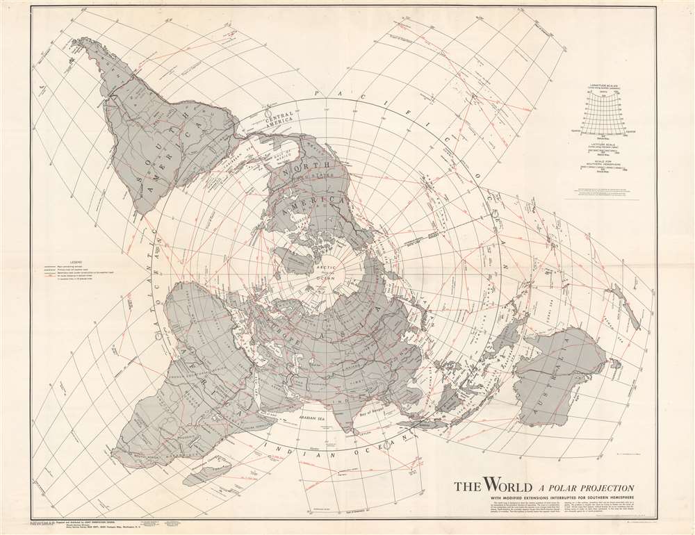
The World. A Polar Projection. With Modified Extensions Interrupted for Southern Hemisphere.
1943 (dated) 32.5 x 42.5 in (82.55 x 107.95 cm)
1943 (dated) 32.5 x 42.5 in (82.55 x 107.95 cm)
Description
This is a two-sided 1943 Army Orientation Course NEWSMAP with a map of the world on a polar projection created by L. F. Vaucher and A. P. Pirola on one side. A global transportation map, Vaucher, and Pirola employ a hybrid projection to most accurately depict worldwide air routes. Red lines highlight these air routes between major cities (which were of extreme importance during World War II) and provide distances in miles. Dashed black and white lines mark significant highways, including recently constructed Alaska Highway, which was completed in 1942. Other depicted highways include a Pan American Highway, depicted here as connecting New York City with Valparaiso and Santiago, Chile, and Buenos Aires, Argentina. Traditionally, the Pan American Highway is illustrated as connecting Buenos Aires and points farther west in the United States, such as Dallas or Denver. The deviation from convention likely comes from the world war and the U.S. government's desire to make it appear that the world is as interconnected as possible. Major roads and highways are also illustrated in northern and central Africa and Asia. The Trans-Siberian Railway and a railway connecting Darwin and Melbourne in Australia are also shown.
Verso Content
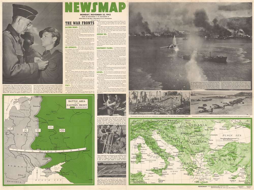
Like all Newsmaps, the verso provides a visual summary of the week's war-related events around the world. Short paragraphs summarize actions on the Eastern Front between the Soviets and the Germans, Allied air offensives in Bulgaria, Germany, France, and Italy, U.S. Marine landings in the Southwest Pacific, and the U.S. Navy's losses on the world's oceans. Photographs accompany the text and portray an even broader swath of events. One photo captures a B-25 Mitchell bomber attacking the Japanese naval base at Rabaul, and another U.S. Navy fighters sitting along an airstrip in the South Pacific. Others show the human side of war: a British soldier bedded down in an empty wine barrel emptying his boot of last night's rain, and a group of Americans inspect a German incendiary rocket. Small maps complete the Newsmap experience and detail the Eastern Front and Southern Europe, with a focus on Italy, where many American bombers are based for attacking targets across occupied Europe.Publication History and Census
This map was compiled by the U.S. Army Orientation Branch and published in November 1943. Nine examples are cataloged in OCLC and are part of the institutional collections at the University of Michigan, the University of California Los Angeles, Pennsylvania State University, Denison University, Ohio Wesleyan University, the Library of Michigan, Southern Illinois University at Edwardsville, the University of Missouri-Columbia, and the Denver Public Library.Cartographer
The Army Orientation Branch (1940 - c. 1949) created special maps for teaching the Army Orientation Course and was based at The Pentagon in Washington, D.C. The Army Orientation Branch was part of the Information and Education Division. More by this mapmaker...
Source
NEWSMAP Series.
Newsmaps were published weekly between April 1942 and March 1946. Their content usually featured world maps, short summaries of the week’s military action, and photographs of troops and materiel. Early Newsmaps were printed on one side only, but, later in the war, they were printed on both sides, with the reverse bearing large-format maps, photographs, or other visual information. Several different versions of Newsmaps were produced: a large domestic version, a smaller overseas version, and an industrial version, which included more information about war production efforts. Two other editions appear in the United States Government Publications Monthly Catalogs, a 'Newsmap Special Edition' and a 'Newsmap Special Supplement for Special Training Units'.
Per the National Archives and Records Administration, ‘NEWSMAPS were not issued for general distribution. The posters were distributed to military installations, government and civilian groups working on War Department projects, and certain depository libraries, as designate by Congress, and one copy to Congressmen, if requested.’ The importance of the Newsmaps to the Army is related in the 1944 Basic Field Manual for The Special Service Company. The Manual states that as soon as the company reaches its destination ‘the company commander should contact the Special Service Branch in theater of operations headquarters, for copies of the weekly Newsmap.’ Also per the Manual
Per the National Archives and Records Administration, ‘NEWSMAPS were not issued for general distribution. The posters were distributed to military installations, government and civilian groups working on War Department projects, and certain depository libraries, as designate by Congress, and one copy to Congressmen, if requested.’ The importance of the Newsmaps to the Army is related in the 1944 Basic Field Manual for The Special Service Company. The Manual states that as soon as the company reaches its destination ‘the company commander should contact the Special Service Branch in theater of operations headquarters, for copies of the weekly Newsmap.’ Also per the Manual
The librarian should check the weekly Newsmap as soon as it is made available and should post it in a conspicuous place. He should take steps to see that the place where the Newsmap is posted is made known to all troops of the area in which the company or platoon is operating. This can be done effectively through notices in soldier newspapers, verbal announcements by those directly in charge of troops, and by posting announcements on bulletin boards.
Condition
Good. Exhibits wear and toning along original fold lines. Closed margin tears professionally repaired on verso.
References
OCLC 48521226 ; 905527462 ; 60844145.