1945 Army Information Branch Newsmap Map of East Asia
Vol4No12F-newsmap-1945$550.00

Title
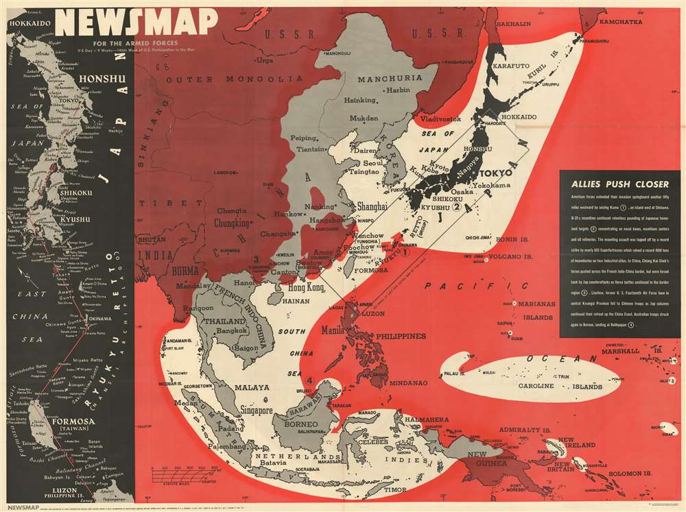
NEWSMAP For the Armed Forces. V-E Day + 9 Weeks - 186th Week of U.S. Participation in the War.
1945 (dated) 35 x 46.5 in (88.9 x 118.11 cm)
1945 (dated) 35 x 46.5 in (88.9 x 118.11 cm)
Description
This is a visually striking 1945 'Army Information Branch Newsmap' map of East Asia. The map depicts the region from western China to the Marshall Islands and from the Soviet Union to New Guinea and the Solomon Islands. Allied Territory is shaded red and highlights the constant pressure being put on Japanese government. The Japanese home islands, colored black, are at the center of a constantly shrinking sphere. A textbox situated along the right border highlights four actions by the Allies as they 'push closer' to Tokyo. Some are territorial moves, such as the invasion of Kume, the Australian landing at Balikpapan on Borneo, and offensives by Chiang Kai-shek's Chinese nationalists in French Indochina and along the Chinese coast. The last of the four is an abhorrent strategic move: the firebombing of four Japanese cities by American B-29 Superfortresses.
The Firebombing of Japan
History has done an incredible job of remembering the atomic bombings of Hiroshima and Nagasaki, with good reason. While these tragedies warrant remembrance, popular memory has largely forgotten that the Japanese suffered devastating bombing attacks by the U.S. Army Air Forces well before Hiroshima and Nagasaki. In early March 1945, American commanders began firebombing Japanese cities with napalm. On the night of March 9, 1945, the American napalm firebombing campaign against Japan began. More than 270 B-29s rained fire on the Japanese capital, dropping over 1,600 tons of bombs. The raid destroyed sixteen square miles of downtown Tokyo, killed an estimated 100,000 civilians, and left over one million people homeless. After a month of strategic bombings in support of the invasion of Okinawa, the firebombing campaign against Japan's other biggest cities commenced in earnest in mid-April and continued through June. In those two months, the Army Air Force destroyed Japan's six largest cities, killed between 112,000 and 127,000 people, and left millions homeless. Incendiary raids against small Japanese cities began in mid-June and continued through the end of the war in August. These raids on small cities could effectively wipe them off the map.Publication History and Census
This map was created by the U.S. Army's Information Branch and distributed to army and navy posts in the United States in early July 1945 to help with training. Eight examples are catalogued in the OCLC and are part of the institutional collections at Denison University, Ohio Wesleyan University, Davidson College, the Library of Michigan, Southern Illinois University at Edwardsville, the University of Missouri – Columbia, Wichita State University, and the Denver Public Library.Source
NEWSMAP Series.
Newsmaps were published weekly between April 1942 and March 1946. Their content usually featured world maps, short summaries of the week’s military action, and photographs of troops and materiel. Early Newsmaps were printed on one side only, but, later in the war, they were printed on both sides, with the reverse bearing large-format maps, photographs, or other visual information. Several different versions of Newsmaps were produced: a large domestic version, a smaller overseas version, and an industrial version, which included more information about war production efforts. Two other editions appear in the United States Government Publications Monthly Catalogs, a 'Newsmap Special Edition' and a 'Newsmap Special Supplement for Special Training Units'.
Per the National Archives and Records Administration, ‘NEWSMAPS were not issued for general distribution. The posters were distributed to military installations, government and civilian groups working on War Department projects, and certain depository libraries, as designate by Congress, and one copy to Congressmen, if requested.’ The importance of the Newsmaps to the Army is related in the 1944 Basic Field Manual for The Special Service Company. The Manual states that as soon as the company reaches its destination ‘the company commander should contact the Special Service Branch in theater of operations headquarters, for copies of the weekly Newsmap.’ Also per the Manual
Per the National Archives and Records Administration, ‘NEWSMAPS were not issued for general distribution. The posters were distributed to military installations, government and civilian groups working on War Department projects, and certain depository libraries, as designate by Congress, and one copy to Congressmen, if requested.’ The importance of the Newsmaps to the Army is related in the 1944 Basic Field Manual for The Special Service Company. The Manual states that as soon as the company reaches its destination ‘the company commander should contact the Special Service Branch in theater of operations headquarters, for copies of the weekly Newsmap.’ Also per the Manual
The librarian should check the weekly Newsmap as soon as it is made available and should post it in a conspicuous place. He should take steps to see that the place where the Newsmap is posted is made known to all troops of the area in which the company or platoon is operating. This can be done effectively through notices in soldier newspapers, verbal announcements by those directly in charge of troops, and by posting announcements on bulletin boards.
Condition
Good. Verso repairs to fold separations. Light wear and toning along original fold lines. Printed text and images on verso.
References
OCLC 55991442.