This item has been sold, but you can get on the Waitlist to be notified if another example becomes available, or purchase a digital scan.
1811 Aquatint View of the Volcanoes of Iztaccihuatl and Popocatepetl
VolcansPuebla-humboldt-1811$150.00

Title
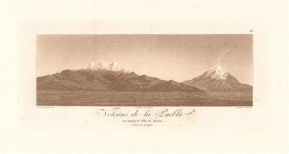
Volcans de la Puebla, vus depuis la Ville de Mexico de l'Imprimerie de Langlois.
1811 (dated 1807) 4.75 x 10.25 in (12.065 x 26.035 cm)
1811 (dated 1807) 4.75 x 10.25 in (12.065 x 26.035 cm)
Description
This scarce 1811 aquatint presents an attractive and quite recognizable view of the mountains of Iztaccihuatl and Popocatepetl, the enormous Mexican volcanoes between Mexico City and Puebla, seen here from the north. The view would have been one the great scientist and explorer would have seen during his 1804 journey between Mexico and Veracruz. The aquatint was based on a drawing by Lud Martin in 1803; the engraving credits the artist as having drawn it from life, and it shows every sign of having been so executed: including the wisps of smoke rising from Popocatepetl's summit. Sadly, about the artist Martin - likely, Don Louis Martin, credited for work on several of Humboldt's maps - the historical record is silent.
The Smoking Mountain
The right-hand mountain depicted is named Popocatéptl, a Nahuatl name literally meaning ’Smoking Mountain.’ It is one of Mexico’s most active volcanoes, with more than fifteen major eruptions since the 16th century. At the time this view was drawn, the most recent eruption had been just one year prior in 1802; the next eruption would not be until 1919. The volcano's current activity began with an eruption in November 2019, which has continued into 2020.The Sleeping 'White Woman'
The left-hand mountain shown, 'Iztaccíhuatl' (Nahuatl for ‘White woman,’ so-called for the resemblance of its four snowy peaks to the profile of a sleeping woman) is, like 'El Popo' a volcano; appropriately, Iztaccíhuatl is dormant.Publication History and Census
This plate appeared in the 1811 edition of Humboldt's Atlas Géographique et Physique du royaume de La Nouvelle Espagne, which OCLC shows in perhaps a dozen examples in institutional collections. The book appears on the market from time to time. The individual plate does not appear in price or auction records.Cartographer
Alexander von Humboldt (September 14, 1769 - May 6, 1859), whose full birth name is Friedrich Wilhelm Heinrich Alexander Freiherr von Humboldt was a German born naturalist, biologist, geologist, explorer and cartographer active in the late 18th and first half of the 19th century. The importance and scope of Humboldt's work is staggering and its influence on both the development of America and the development of science itself is second to none. As Emil Du Bois-Reymond said, "Every scientist is a descendant of Humboldt. We are all his family." To compose a full biography of Humboldt is the work of volumes, not this simple medium, so we will attempt to focus on the highlights of Humboldt's life as it pertains to cartography. Humboldt was the first scientist to embrace and actually take into the field the Kantian concept of a union between careful scientific observation and intuitive analysis. Between 1799 and 1804 Humboldt traveled through northwestern South America, Central America, Mexico, and parts of the United States. During this voyage he collected a wealth scientific observations and measurements, including considerable surveying and cartographic work, in each of the regions through which he passed. Humboldt's mapping of Mexico, then inclusive of much of the southwestern part of the United States, was an accomplishment of seminal importance, not only because it was the finest map of the region yet produced, but also because of its impact on the future political geography of the Americas. Upon his arrival in Washington, Humboldt struck up a friendship with president Thomas Jefferson, soon to be president James Madison, and other luminaries of post Colonial America. He freely shared his mappings of Mexico with the U.S. President, little suspecting that they would soon influence the results of the Mexican American War and the manifest destiny movement that would follow. When he returned to Germany, Humboldt began a life-long correspondence with scientific luminaries and explorers throughout the world and most particularly in America. Humboldt's influence can be directly tagged to the development of numerous important careers in American cartography, including those of Nicolette, Fremont, Wilkes, Hassler, Bache, and others. Though Humboldt never again visited America, his name is etched across our landscape through numerous Mountains, Rivers, Islands, and other geological features that bear his name. Had the votes in Congress swayed slightly to the other direction, even the entire state of Nevada would have been the state of Humboldt. Throughout his life, Humboldt was a tireless supporter of human equality, scientific advancement, and personal liberty. Humboldt died in Berlin at 89 years old, in his long life he was an inspiration to the invention of modern anthropology, the political destiny of South America, the geographical exploration of the American West, and, ultimately, the development of modern science. More by this mapmaker...
Source
Humboldt, A. von. Atlas Geographique Et Physique Du Royaume De La Nouvelle-Espagne, Fonde Sur Des Observations Astronomiques, Des Mesures Trigonometriques Et Des Nivellemens Barometriques. Par Al. De Humboldt. Paris, Chez F. Schoell, 1811.
Condition
Very good condition. Some marginal spots, else excellent with wide margins.
References
Rumsey 0328.000. OCLC 699497289.