1945 Army Info Branch Newsmap Map of the Battle Fronts in Europe and Asia
VolIVNo10FOverseas-newsmap-1945$375.00


Title
NEWSMAP Overseas Edition For the Armed Forces. V-E Day + 7 Weeks - 184th Week of U.S. Participation in the War. Monday, 2 July 1945. Week of 12 June to 19 June. Vol. IV No 10F.
1945 (dated) 16.5 x 23.25 in (41.91 x 59.055 cm)
1945 (dated) 16.5 x 23.25 in (41.91 x 59.055 cm)
Description
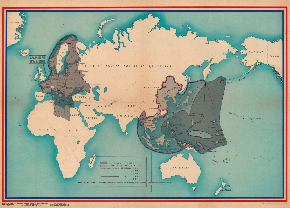
A piece of Allied propaganda created for soldiers, this is a 1945 U.S. Army Information Branch Newsmap map of the battle fronts in Europe and Asia. Published a few months after Germany surrendered, this piece celebrates the achievements of Allied armies in Europe while illustrating how much farther there is to go in Asia and the Pacific.
A Closer Look
Focusing on the theaters of war, dark gray highlights areas liberated by the Allies since December 7, 1941 (Pearl Harbor Day). Red and blue lines illustrate the battle fronts in 1941, 1942, 1943, and 1944, illustrating a progression toward Allied victory. Light gray in Asia and the Pacific are territory still held by the Japanese as of May 8, 1945 (V-E Day). A key is situated at center along the bottom border and includes the recommendation, 'Keep This Map Alive - Don't let it become just a decoration - add your own phase lines, shade in the enemy areas taken daily until V-J Day'. Since this piece was published in early July, the war would rage for another 6 weeks before Japan surrendered.Verso Content
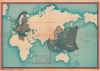
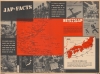
The verso is densely packed with information and propaganda. A bright red map occupies the center and indicates six events that took place over the course of the week. Among these were firebombings of cities on Kyushu and Honshu, the climax of the Okinawa campaign, hard fighting on Luzon and Mindanao, and an amphibious landing in Brunei Bay. The map is encircled by propaganda, presented here as 'facts'. Some, such as the strength of the Japanese armed forces, appear factual, while others, including commentary on Japanese 'fanaticism', are most certainly propaganda. Printed photographs depict a factory making artillery pieces, a Japanese fighter, and a captured Japanese submarine. A small map in the lower right corner emphasizes the continuous aerial bombardment of the Japanese home islands and states that 5,480 tons of bombs would be dropped daily on Japan.Publication History and Census
This map was prepared and distributed by the Army Information Branch in July 1945. This is an Overseas Edition, which is smaller than the domestic Newsmaps. Also, since they were sent overseas, the Overseas Editions have a much higher attrition rate, making this a rare find compared with the domestic edition. We note a single example of the present Overseas Edition of this Newsmap in OCLC and it is part of the collection at Texas A and M University.Cartographer
The Army Orientation Branch (1940 - c. 1949) created special maps for teaching the Army Orientation Course and was based at The Pentagon in Washington, D.C. The Army Orientation Branch was part of the Information and Education Division. More by this mapmaker...
Source
NEWSMAP Series.
Newsmaps were published weekly between April 1942 and March 1946. Their content usually featured world maps, short summaries of the week’s military action, and photographs of troops and materiel. Early Newsmaps were printed on one side only, but, later in the war, they were printed on both sides, with the reverse bearing large-format maps, photographs, or other visual information. Several different versions of Newsmaps were produced: a large domestic version, a smaller overseas version, and an industrial version, which included more information about war production efforts. Two other editions appear in the United States Government Publications Monthly Catalogs, a 'Newsmap Special Edition' and a 'Newsmap Special Supplement for Special Training Units'.
Per the National Archives and Records Administration, ‘NEWSMAPS were not issued for general distribution. The posters were distributed to military installations, government and civilian groups working on War Department projects, and certain depository libraries, as designate by Congress, and one copy to Congressmen, if requested.’ The importance of the Newsmaps to the Army is related in the 1944 Basic Field Manual for The Special Service Company. The Manual states that as soon as the company reaches its destination ‘the company commander should contact the Special Service Branch in theater of operations headquarters, for copies of the weekly Newsmap.’ Also per the Manual
Per the National Archives and Records Administration, ‘NEWSMAPS were not issued for general distribution. The posters were distributed to military installations, government and civilian groups working on War Department projects, and certain depository libraries, as designate by Congress, and one copy to Congressmen, if requested.’ The importance of the Newsmaps to the Army is related in the 1944 Basic Field Manual for The Special Service Company. The Manual states that as soon as the company reaches its destination ‘the company commander should contact the Special Service Branch in theater of operations headquarters, for copies of the weekly Newsmap.’ Also per the Manual
The librarian should check the weekly Newsmap as soon as it is made available and should post it in a conspicuous place. He should take steps to see that the place where the Newsmap is posted is made known to all troops of the area in which the company or platoon is operating. This can be done effectively through notices in soldier newspapers, verbal announcements by those directly in charge of troops, and by posting announcements on bulletin boards.
Condition
Very good. Closed margin tears professionally repaired on verso. Slight loss to margin in lower left corner. Text and printed photographs on verso.
References
OCLC 1159987621.