This item has been sold, but you can get on the Waitlist to be notified if another example becomes available, or purchase a digital scan.
1945 U.S. Army Information Branch Map of Japan and the Planned Amphibious Invasion
VolIVNo26FOlympic-newsmap-1945$225.00


Title
Newsmap Middle Pacific. The Planned Assault on Japan. Monday 15 October, 1945. Week of 2 October to 9 October. Volume IV No. 26F.
1945 (dated) 16.5 x 22 in (41.91 x 55.88 cm) 1 : 3456000
1945 (dated) 16.5 x 22 in (41.91 x 55.88 cm) 1 : 3456000
Description
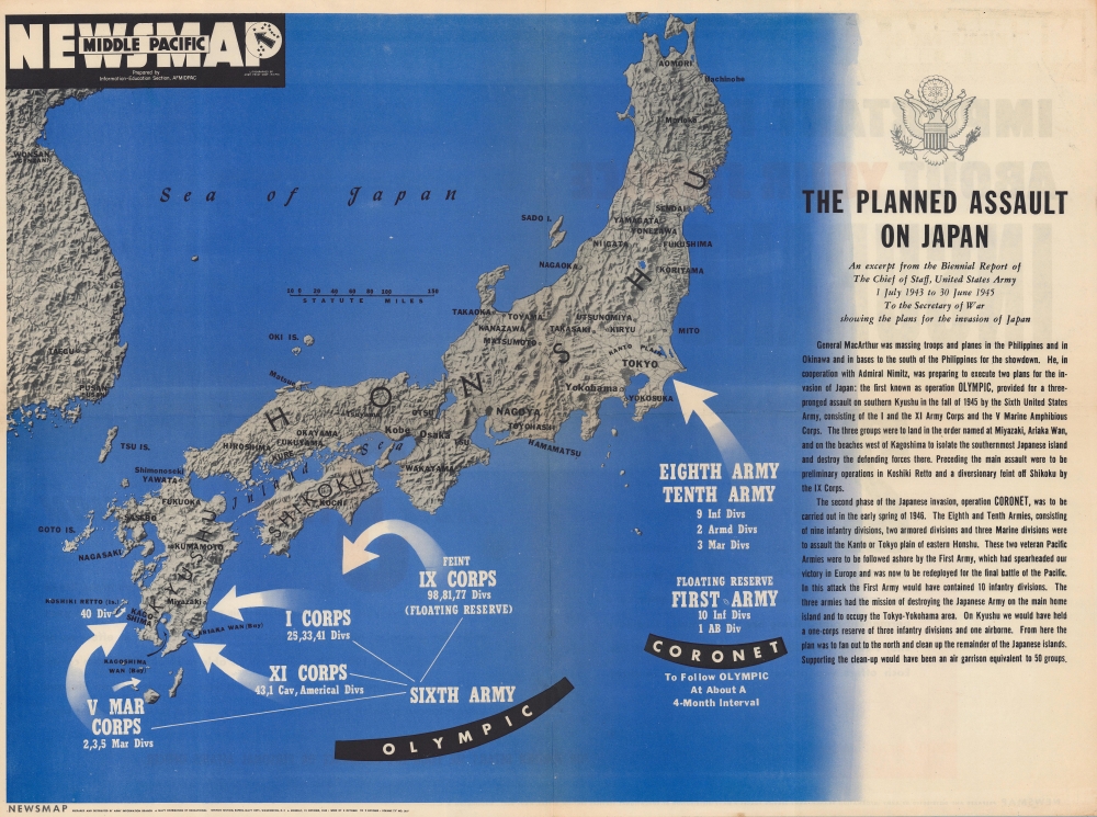
This is a rare Overseas Edition Newsmap published in October 1945 (1 month after the Japanese surrender) illustrating the planned amphibious invasions of the Japanese home islands.
A Closer Look
Three of the Japanese home islands appear here (Honshu, Shikoku, and Kyushu). Large white arrows illustrate Operation Olympic and Operation Coronet. The arrows for Operation Olympic mark approximately where American divisions would assault southern Kyushu with ten divisions landing on Kyushu and another three would act as a feint and floating reserve. Text along the right side provides a short summary of both operations and some of the units involved.Operation Downfall
Operation Downfall was the codename given to the final assault on Japan. This plan was divided into two separate amphibious landings. Operation Olympic was set for November 1, 1945, and would invade southern Kyushu. Operation Coronet was scheduled to take place on March 1, 1946, and would invade Honshu at the Tokyo Plain. Plans for Operation Olympic stated that 582,560 troops would be landed on the first day and be spread over 35 invasion beaches. (For comparison, Operation Overlord, the invasion of Normandy, included almost 160,000 troops and nearly 7,000 ships and is the largest amphibious invasion in history.) U.S. military casualty estimates continued to mount throughout 1945, with experiences on Iwo Jima and Okinawa guiding these changes in understanding. U.S. casualty estimates vary wildly, but by late July 1945 the War Department estimated that Operation Downfall would cause between 1.7 and 4 million casualties, with between 400,000 and 800,000 Americans killed. The War Department Japanese casualty estimates in late July 1945 were that between 5 million and 10 million Japanese would be killed. These accuracy of these numbers (and the fact that there is so much variation in the estimates) play a part in the ongoing debate about the use of the atomic bombs. While we will never know what the numbers would have been, it is clear that an invasion of Japan would have been catastrophic for both sides.Japanese Defense Plans
While this map focuses only on planned American operations, any discussion of Operation Downfall should also include Japan's defensive plans, called Operation Ketsugo, or Decisive Operation. It is clear from Japanese records that Japan did not plan to hold anything back for the defense of Tokyo. Their goal was to thwart the American invasion of Kyushu at almost all costs. All their aircraft and naval vessels would be committed to the defense of Kyushu (which they had correctly guessed would be the location of the upcoming invasion). They had also sent 900,000 soldiers to occupy Kyushu and repel the invasion, which far exceeded U.S. military estimates of Japanese defensive strength. (American plans called for the initial assault to comprise 582,500 men (as stated above) and for the total occupation force to top out at 766,700). The Japanese also planned to use everything in their arsenal to attack American troop ships and landing craft. Their main strategy was to cause as many American casualties as possible to make the stated objective of unconditional surrender politically impossible. The last and perhaps most devastating aspect of the Japanese plan was to not evacuate the civilian population. Japanese civilians had been barraged with propaganda since the early 1930s, conditioning the populace to believe certain things and think certain ways. In the summer of 1945, one of these propaganda slogans stated, 'The sooner the Americans come, the better…100 million die proudly'. With this strategy, not only would the invading American army be fighting the Japanese military, but also the civilian population. For more information on Operation Downfall we highly recommend the Naval History and Heritage Command's history. (https://www.history.navy.mil/about-us/leadership/director/directors-corner/h-grams/h-gram-057/h-057-1.html)Publication History and Census
This map was prepared by the Information-Education Section of AFMIDPAC (Armed Forces Middle Pacific) and lithographed by the MIDPAC Army Print Shop. Overseas editions of Newsmaps like the present example were significantly smaller than the domestic editions distributed to armed forces installations across the United States. This is the only known cataloged example of the Overseas Edition of this Newsmap. The OCLC catalogs 7 examples of the domestic edition in libraries across the United States.Cartographer
The Army Orientation Branch (1940 - c. 1949) created special maps for teaching the Army Orientation Course and was based at The Pentagon in Washington, D.C. The Army Orientation Branch was part of the Information and Education Division. More by this mapmaker...
Source
NEWSMAP Series.
Newsmaps were published weekly between April 1942 and March 1946. Their content usually featured world maps, short summaries of the week’s military action, and photographs of troops and materiel. Early Newsmaps were printed on one side only, but, later in the war, they were printed on both sides, with the reverse bearing large-format maps, photographs, or other visual information. Several different versions of Newsmaps were produced: a large domestic version, a smaller overseas version, and an industrial version, which included more information about war production efforts. Two other editions appear in the United States Government Publications Monthly Catalogs, a 'Newsmap Special Edition' and a 'Newsmap Special Supplement for Special Training Units'.
Per the National Archives and Records Administration, ‘NEWSMAPS were not issued for general distribution. The posters were distributed to military installations, government and civilian groups working on War Department projects, and certain depository libraries, as designate by Congress, and one copy to Congressmen, if requested.’ The importance of the Newsmaps to the Army is related in the 1944 Basic Field Manual for The Special Service Company. The Manual states that as soon as the company reaches its destination ‘the company commander should contact the Special Service Branch in theater of operations headquarters, for copies of the weekly Newsmap.’ Also per the Manual
Per the National Archives and Records Administration, ‘NEWSMAPS were not issued for general distribution. The posters were distributed to military installations, government and civilian groups working on War Department projects, and certain depository libraries, as designate by Congress, and one copy to Congressmen, if requested.’ The importance of the Newsmaps to the Army is related in the 1944 Basic Field Manual for The Special Service Company. The Manual states that as soon as the company reaches its destination ‘the company commander should contact the Special Service Branch in theater of operations headquarters, for copies of the weekly Newsmap.’ Also per the Manual
The librarian should check the weekly Newsmap as soon as it is made available and should post it in a conspicuous place. He should take steps to see that the place where the Newsmap is posted is made known to all troops of the area in which the company or platoon is operating. This can be done effectively through notices in soldier newspapers, verbal announcements by those directly in charge of troops, and by posting announcements on bulletin boards.
Condition
Very good. Light wear along original fold lines. Verso repairs to fold separations. Closed margin tears professionally repaired on verso. Light edge wear. Text on verso.