
1925 Gray Map of Volusia County, Florida

This item has been sold.
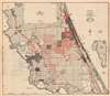
Gray's Map of Volusia County Showing Range Township and Section Lines.
Early state survey of Volusia County.
Choose a Collection:
- Digital Map Information
- Suitable for large format printing
- Full resolution TIFF file
- ICC color profile embedded
- Delivered instantly via download link
This Item
Enquire
Early state survey of Volusia County.
This is a 1929 C. J. Gray map of Volusia County, Florida. Likely meant as a real estate map, Gray presents the county's range, township, and section lines. Red overprinting highlights land owned by real estate developers, such as Daytona Park Properties and Harry E. Prettyman, Inc. Properties. Gray also uses red overprinting to emphasize railroad lines, highways, and roads. Cities, including Daytona Beach, De Land, and New Smyrna, are illustrated. A close observer will notice plots that do not conform with the Range, Township, and Section lines. These are old estates predating Florida's annexation.A Short Explanation of a Township
The township was created as the measure of the Public Land Survey System, which was first widely implemented to survey the Northwest Ordinance. The Public Land Survey System allowed for the systematic surveying and mapping of any territory gained by the United States. It played a pivotal role in subsequent settlement and administration of new territories and states. The work of the survey influenced American Indian removal efforts, town-building, railroad grants, new settlements, and more. Moreover, the efforts of the Federal Land Survey were significant in centralizing power with the Federal Government at the expense of states.Publication History and Census
This map was published by C. J. Gray in 1925. This is the only known cataloged example.Condition
Very good. Light wear along original fold lines. Very minor loss at a handful of fold separations.