
1827 Cary Case Map of Wales

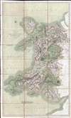
A New Map of the Principality of Wales. Divided into Counties.
Beautifully engraved map of Wales.
- Digital Map Information
- Suitable for large format printing
- DPI: 300
- File Size: 26.24 MB
- File Type: ZIP / TIFF
- ICC color profile embedded
- Delivered instantly via download link
Beautifully engraved map of Wales.
This is an 1827 John Cary map of Wales. The map depicts the country from St. George's Channel to Herefordshire, Shropshire, and Monmouthshire in England and from the Irish Sea to Bristol Channel and Somersetshire. Beautifully engraved, Cary effortlessly blends physical geography with political and man-made geography, noting counties, cities, towns, and villages throughout Wales, including Cardiff, Swansea, and Wrexham. Roads snake their way across the country, easily intertwining England and Wales. Mountains, woods, and lakes are also noted.Publication HIstory
This map was engraved and published by John Cary in 1827. It is of note that this map does not appear in John Cary: Engraver, Map, Chart and Print-Seller and Globe-Make 1754 to 1835 by Sir Herbert George Fordham.Cartographer
John Cary (1754 - August 1835) was a London based cartographer active in the early part of the 19th century. Ronald Vere Tooley, the prominent English map historian, writes of Cary, "As an engraver he was elegant and exact with fine clear lettering and great delicacy of touch." Cary began his work as an engraver, cartographer, and globe maker in 1776 with his New and Correct English Atlas. This important atlas represented a new phase in cartography where accuracy and detail rose in prominence over the decorative embellishments of the 18th century. This change was indicative of the times when travel and commerce were expanding globally as never before. Cary's mastery of both engraving and cartography resulted in a series of seminal works that redefined mapmaking in the early 19th century. His stupendous Cary's New Universal Atlas, published in 1808, set the standard for all cartographers who followed. Cary reissued this seminal atlas in 1811, 1819, 1824, 1828, 1833, 1836 and 1844. Cary also did considerable work on the English Ordinance Survey prior to 1805. His cartographic work, of where there are more than 600 maps known, particularly inspired the Edinburgh school of cartography as represented by John Pinkerton and John Thomson. In America, Cary's work was used as the basis for Tanner's important New American Atlas. Cary's last published atlas appeared posthumously in 1844, however, by 1850 Cary's work was being carried on by his sons and other well-known cartographers including James Wyld, John Tallis & Company, and Crutchley. Further Details...
Condition
Very good. Dissected and mounted on linen in 24 panels. Close margins. Blank on verso. Accompanied by original binder.
References
OCLC 557867619.