This item has been sold, but you can get on the Waitlist to be notified if another example becomes available, or purchase a digital scan.
1910 Rand McNally Map or Plan of Washington D.C.
WashingtonDC-randmcnally-1910$87.50

Title
Washington D.C.
1910 (dated) 20 x 27 in (50.8 x 68.58 cm) 1 : 15000
1910 (dated) 20 x 27 in (50.8 x 68.58 cm) 1 : 15000
Description
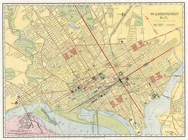
This is a beautiful 1910 map or plan of Washington D.C. by Rand McNally and Company. It covers Washington D.C. from the Potomac River to the Anacostia River and north to the U.S. Soldier's Home. The map is exceptionally detailed, noting important buildings, streets, monuments, electric lines, parks, and steams railroads. Some of the sites other than the U.S. Capitol Building, the Supreme Court, and the Executive Mansion, also known as the White House, include the Medical Museum, which is located on the National Mall close to the Smithsonian Institution, the U.S. Naval Museum of Hygiene, the National Zoological Park, Howard University, and the Columbia Institution for the Deaf and Dumb. Union Station, Georgetown College, and the Government Printing Office are also depicted on this map. The city is divided in four sections marked N.W., S.W., S.E., and N.E., by lines emanating from the Capitol Building.
The map was published by Rand McNally and Company in 1910.
The map was published by Rand McNally and Company in 1910.
Cartographer
Rand, McNally and Co. (fl. 1856 - present) is an American publisher of maps, atlases and globes. The company was founded in 1856 when William H. Rand, a native of Quincy, Massachusetts, opened a print shop in Chicago. Rand hired the recent Irish immigrant Andrew McNally to assist in the shop giving him a wage of 9 USD per week. The duo landed several important contracts, including the Tribune's (later renamed the Chicago Tribune) printing operation. In 1872, Rand McNally produced its first map, a railroad guide, using a new cost effective printing technique known as wax process engraving. As Chicago developed as a railway hub, the Rand firm, now incorporated as Rand McNally, began producing a wide array of railroad maps and guides. Over time, the firm expanded into atlases, globes, educational material, and general literature. By embracing the wax engraving process, Rand McNally was able to dominate the map and atlas market, pushing more traditional American lithographic publishers like Colton, Johnson, and Mitchell out of business. Eventually Rand McNally opened an annex office in New York City headed by Caleb S. Hammond, whose name is today synonymous with maps and atlases, and who later started his own map company, C. S. Hammond & Co. Both firms remain in business. More by this mapmaker...
Source
Rand McNally and Co., Rand, McNally and Co.'s Business Atlas (Chicago) 1910.
Condition
Very good. Minor wear along original fold lines. Blank on verso.
References
Library of Congress Geography and Map Division G3850 1910 .R3.