
1943 A.F. Free Guide and Map of Washington, D.C. for Service Men and Women

This item has been sold.
Information Map and Guide Washington, D.C. and Environs for Service Men and Women and War Workers.
Visiting Washington, D.C. during World War II.
Choose a Collection:
- Digital Map Information
- Suitable for large format printing
- Full resolution TIFF file
- ICC color profile embedded
- Delivered instantly via download link
This Item
Enquire
Visiting Washington, D.C. during World War II.
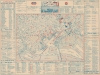
An obscure relic of the World War II home front, this is a 1943 Allen F. Free and USO city plan or map of Washington, D.C. made for service men and women and war workers. The map was issued to help the multitudes of war-time visitors enjoy the city.A Closer Look
Depicting central Washington, D.C. from the Key Bridge to the Army War College and from Union Station to the Potomac River, just over 100 locations are numerically identified throughout the city and correspond with an index bordering the map on all sides. In all, 298 locations appear in the index, however only the sites identified by red numbers can be immediately referenced on the map. Other locations are labeled directly on the map, such as the Ellipse, the Department of Commerce, the Department of the Interior, the Federal Reserve, and the U.S. Naval Hospital, to name a few. Streets, avenues, parks, squares, and circles are labeled as well. Sections of the index include hotels, service clubs, bus terminals, Officers' clubs, hospitals, theaters, night clubs, and churches.Publication History and Census
This map was created and copyrighted by Allen F. Free and published and distributed by the Washington Council of United Service Organization, Inc. (better known as the USO) on May 16, 1943. We note three examples cataloged in OCLC which are part of the collections at the Library of Congress, the University of Michigan, and Stanford University. We are aware of a second edition of this piece, published in December 1943. We have found no market history for this piece.Condition
Very good. Light wear along original fold lines. Light toning.
References
OCLC 16524155.