This item has been sold, but you can get on the Waitlist to be notified if another example becomes available, or purchase a digital scan.
1866 Mitchell Map of Washington, Oregon, Idaho and Montana
WashingtonOregonIdaho-mitchell-1866$100.00

Title
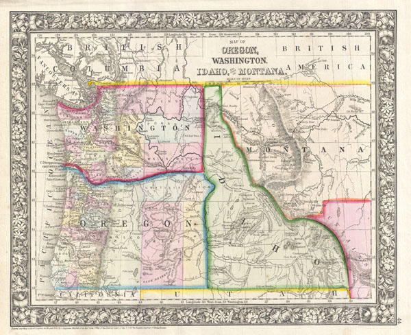
Map of Oregon, Washington, Idaho, and part of Montana.
1866 (dated 1860) 11 x 13.5 in (27.94 x 34.29 cm)
1866 (dated 1860) 11 x 13.5 in (27.94 x 34.29 cm)
Description
A beautiful example of S. A. Mitchell Junior's 1866 map of Washington, Oregon, Idaho and Montana. Color coded according to county and territory. Identifies the proposed Stevens route for the Northern Pacific Railroad as well as the Emigrant Road. Gold deposits are noted near Hells Gate Montana, north of Boise Idaho, and along the Idaho Montana border. Shows various geographic features, American Indian tribes, and notable peaks as well as providing details on towns, counties, and other political data. Subsequent editions of this map add more sophisticated county breakdowns in Montana and Idaho. One of the most interesting and ephemeral maps of this transitional region to appear in the mid 19th century. Surrounded by the attractive floral border common to Mitchell atlases between 1860 and 1866. Prepared by W. H. Gamble for inclusion as plate 44 in the 1866 issue of Mitchell's New General Atlas. Like many American map publishers of this period, though he did update his maps, Mitchell did not update his copyrights, consequently this map is dated and copyrighted to 1861: 'Entered according to Act of Congress in the Year 1861 by S. Augustus Mitchell Jr. in the Clerk's Office of the District Court of the U.S. for the Eastern District of Pennsylvania.'
Cartographer
Samuel Augustus Mitchell (March 20, 1792 - December 20, 1868) began his map publishing career in the early 1830s. Mitchell was born in Bristol, Connecticut. He relocated to Philadelphia in 1821. Having worked as a school teacher and a geographical writer, Mitchell was frustrated with the low quality and inaccuracy of school texts of the period. His first maps were an attempt to rectify this problem. In the next 20 years Mitchell would become the most prominent American map publisher of the mid-19th century. Mitchell worked with prominent engravers J. H. Young, H. S. Tanner, and H. N. Burroughs before attaining the full copyright on his maps in 1847. In 1849 Mitchell either partnered with or sold his plates to Thomas, Cowperthwait and Company who continued to publish the Mitchell's Universal Atlas. By about 1856 most of the Mitchell plates and copyrights were acquired by Charles Desilver who continued to publish the maps, many with modified borders and color schemes, until Mitchell's son, Samuel Augustus Mitchell Junior, entered the picture. In 1859, S.A. Mitchell Jr. purchased most of the plates back from Desilver and introduced his own floral motif border. From 1860 on, he published his own editions of the New General Atlas. The younger Mitchell became as prominent as his father, publishing maps and atlases until 1887, when most of the copyrights were again sold and the Mitchell firm closed its doors for the final time. More by this mapmaker...
Source
Mitchell, S. A., Mitchell's New General Atlas Containing Maps of the Various Countries of the World, Plans of Cities, Etc., embraced in Fifty-Five Quarto Maps, Forming a series of Eight-Seven Maps and Plans, together with Valuable Statistical Tables, 1866 edition.
Condition
Very good. Blank on verso.
References
Rumsey 2483.039 (1870). Bancroft Library G4360 1870 .M5 (1871 ed., c1870).