This item has been sold, but you can get on the Waitlist to be notified if another example becomes available, or purchase a digital scan.
1871 Spangenberg Map of Washington Square Park, New York
WashingtonSquarePark-spangenberg-1871$275.00

Title
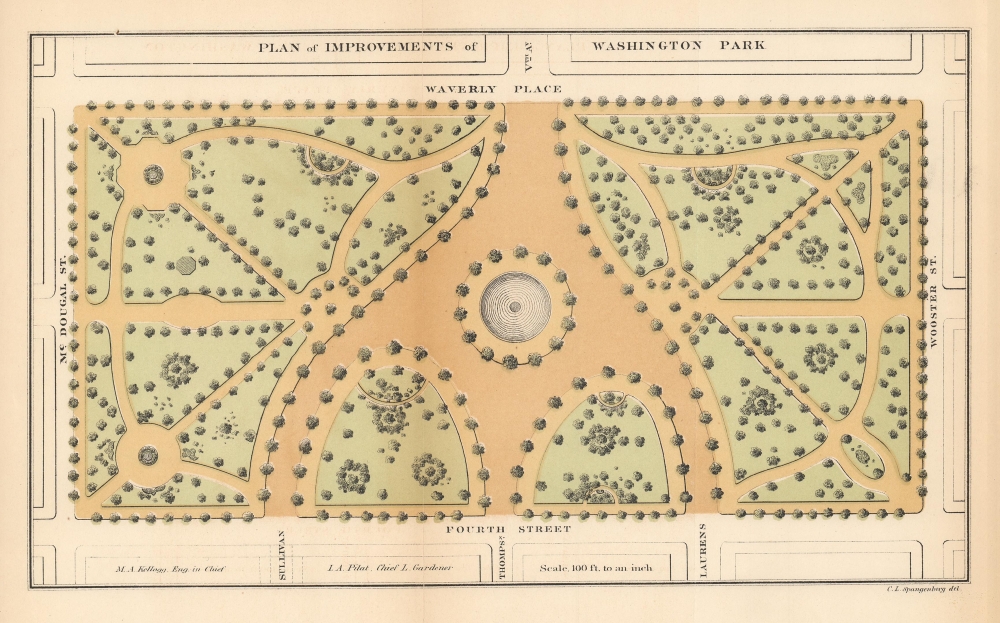
Plan of Improvements of Washington Park.
1871 (undated) 7 x 11.5 in (17.78 x 29.21 cm)
1871 (undated) 7 x 11.5 in (17.78 x 29.21 cm)
Description
This is the first published map of Washington Square Park, Greenwich Village, New York. The map was issued during the 1871 conversion of the square from a military parade ground to a public park.
Washington Square Park
Washington Square Park is situated in Manhattan's Greenwich Village. The square has a long history as a public place. During the American Revolutionary War (1775 - 1783), when the park was still beyond the city's limits, it was used as a soldier's cemetery. During the Cholera Epidemic of 1798, it became a mass grave. To this day, more than 20,000 remains are buried underneath Washington Square Park. Nonetheless, by the 1820s, it had been converted into a military parade ground, with Common Council legislation guaranteeing it would not be lotted and would remain an open green space. After the American Civil War (1861 - 1865), the need for a volunteer militia training ground diminished, and plans were made to turn the square into a recreational park. These manifested in 1871, when the square was renovated, and the park took on its current configuration, with winding pathways. Around this time, the New York Park Department began using the park for organized outdoor concerts and theatrical productions - setting the stage for its modern reputation as a haven for the arts. The famous Washington Square Arch, designed by Stanford White, was added in 1891.Publication History
This plan was created by Charles L. Spangenberg for the First Annual Report of the Board of Commissioners of the Department of Public Parks for the Year Ending May 1, 1871.Cartographer
Charles Spangenberg(fl. c. 1862 - 1872) was a topographical draftsman active in the mid to late 19th century. Spangenberg served with the Union Army during the American Civil War (1861 - 1865). His name is attached to at least one important Civil War manuscript maps, of the Battle of Vicksburg, as well as published maps of multiple other battles. After the war, he was active in New York City, where he drew several maps for the New York Parks Commission. More by this mapmaker...
Source
Bryant, William C., First Annual Report of the Board of Commissioners of the Department of Public Parks for the Year Ending May 1, 1871, (New York) 1871.
Condition
Very good. Laid on archival tissue.