This item has been sold, but you can get on the Waitlist to be notified if another example becomes available, or purchase a digital scan.
1859 Isaac Stevens Map of Washington Territory, surveyed for the Railroad
WashingtonTerritory-stevens-1859$600.00


Title
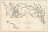
Map No. 3 Rocky Mountains to Puget Sound; from Explorations and Surveys Made Under the Direction of the Hon. Jefferson Davis Secretary of War.
1859 (undated) 24.5 x 36.5 in (62.23 x 92.71 cm) 1 : 1200000
1859 (undated) 24.5 x 36.5 in (62.23 x 92.71 cm) 1 : 1200000
Description
This is a superb example of the map detailing Isaac Stevens' 1853-1854 reconnaissance of a railway route through the Rocky Mountains to the Pacific. This was part of a broad United States effort to determine a workable rail route to the Pacific through the Rockies, in the hope of opening Asian markets to American trade. Stevens, then en route to take up his new role as governor and Superintendent of Indian Affairs for the Washington Territory, successfully bid to undertake this survey of the route, which was executed over most of 1853 and part of 1854.
A Closer Look
Carl Wheat, in Transmississippi West, admires this map, calling itthe most complex of all that were made of Stevens' exploration… it is an excellent map and one which indicates clearly the difficulties encountered in getting a railroad route through the various ranges of mountains that lie east from tidewater to the summit of the Rockies.Focusing predominantly north of the Columbia River, the map begins in the east at the Snake and Marias Rivers, all the way to the Pacific coast between the Columbia and Vancouver Island. The intervening space - covering what is now western Montana, northern Idaho, and Washington State - is occupied by the Rocky Mountains, indicated pictorially with hachure. The map's primary content is the array of routes taken by Stevens, subordinates in his expedition, and several other surveys, marked in light dotted lines through the hachured mountains. Darker dotted lines indicate routes that the survey considered probably practicable; the solid black lines indicate routes recommended as practicable railroad routes. Detailed notes indicate specific types of terrain, mountain peaks, features such as hot springs, forests, military camps, missions, and Native American settlements.
A Fortunate Survival
The map was included in the 1857-1860 quarto edition of the Pacific Railroad Reports, that is Reports of Explorations and Surveys to Ascertain the Most Practicable and Economical Route for a Railroad from the Mississippi River to the Pacific Ocean. According to Wheat, the maps for this monumental production were published in volume XI, in 1859. These tended to survive poorly. Wheat commented, in 1959, thatthe maps are generally very large and thus require many-folded sheets, with the result that over the years the folds (or some of them) have greatly deteriorated and are often torn or discolored, even in instances where they have remained folded. And where they have been unfolded from time to time they are inevitably torn…The present example, happily, is predominantly free of these indignities, and barring a few spots and one closely trimmed margin, is in remarkably clean condition.
Publication History and Census
This map, based on surveys executed between 1853 and 1855, was lithographed in Washington, D.C. by Selmar Siebert in 1859 for inclusion in volume XI of Reports of explorations and surveys to ascertain the most practicable and economical route for a railroad from the Mississippi River to the Pacific Ocean. Perhaps a dozen examples of the separate map are listed in OCLC. The bound reports are ubiquitous in institutional collections.Cartographer
Isaac Ingalls Stevens (March 25, 1818 – September 1, 1862) was an American military officer and politician. He served as governor of the Territory of Washington from 1853 to 1857, and later as its delegate to the United States House of Representatives; he was also Superintendent of Indian Affairs. He was a polarizing figure, whose tenure as governor overwhelms Washington's territorial history; accounts of him condemn or applaud. A New Englander, the diminutive Stevens graduated from Phillips Academy in 1833. He attended West Point, where he graduated at the top of his class. He became career military. He was adjutant of the Corps of Engineers during the Mexican-American War, performing with distinction in combat. He swiftly earned wartime promotions to Captain and Major, and received severe wounds in combat. He would in 1851 publish a book on his experiences during the war. Between 1841 and 1849 he was superintendent of fortifications on the New England coast, and was given command of the coast survey until 1853. His support of fellow Mexican War veteran Franklin Pierce led him to be rewarded by the new President Pierce by being made governor and Superintendent of Indian Affairs for the new Washington Territory. Stevens also undertook to use his travel west as an opportunity to survey a railroad route across the northern United States (he was an experienced engineer, although his connections with President Pierce and Secretary of War Jefferson Davis doubtless aided his bid.)He would publish the results of his survey in 1855. His governorship would prove controversial. Aggressive in diplomacy as well as war, he compelled Native American tribes of Washington Territory by both intimidation and force, and was not above forging signatures on treaties. His tenure resulted in the Treaties of Medicine Creek, Treaty of Hellgate, Treaty of Neah Bay, Treaty of Point Elliott, Point No Point Treaty, and Quinault Treaty. He imposed martial law to remove dissent from both the Indians and Whites who opposed his policies. He jailed opposing judges, and raised a private army - for which he was convicted for contempt of court, rebuked by the President of the United States. Despite opposition, he was popular enough among white settlers in the Territory to be elected as the territory's delegate to the United States Congress in 1857 and 1858. During the American Civil War, he held several Union commands and was - at the time of his death - under consideration for appointment to command the Army of Virginia. He was killed at the Battle of Chantilly, leading his men from the front, carrying the fallen colors of one of his regiments against Confederate positions. He was posthumously promoted to Major General. More by this mapmaker...
Condition
Very good. Some wear at folds and few spots. Left margin extended.
References
OCLC 44942976. Rumsey 0693.022. Wheat, Carl Irving, Mapping the Transmississippi West, 1540-1861, v. 3, no. 866.