This item has been sold, but you can get on the Waitlist to be notified if another example becomes available, or purchase a digital scan.
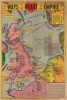
1941 Sundberg Map of Britain Illustrating Possible Invasion Points
WaysHeartEmpire-sundberg-1941$175.00


Title
Ways to the Heart of the Empire.
1941 (dated) 22 x 14.75 in (55.88 x 37.465 cm) 1 : 13464000
1941 (dated) 22 x 14.75 in (55.88 x 37.465 cm) 1 : 13464000
Description
This is a 1941 Edwin Sundberg pictorial map of Britain and northwestern Europe focusing on a potential Nazi invasion of Britain.
A Closer Look
Illustrating British defenses and possible Nazi invasion routes, mine fields, coastal artillery, and coastal defensive lines are illustrated. Aerial routes between continental Europe and Scandinavia and their targets in Britain are depicted with flight times are provided, along with bomber ranges from Amsterdam, Brest, and Bergen. Yellow text boxes comment on British beaches and defenses, along with what attributes certain areas have that would be conducive to an invasion. British industrial areas, airfields, and resources are presented pictorially.The Battle of Britain and Operation Sea Lion
Although this map was published three and a half months after the end of the Battle of Britain (July 10 - October 31, 1940), an invasion of Britain still seemed a very real possibility. After the fall of France in June 1940, Hitler believed that an armistice with Britain was imminent. However, British Prime Minister Winston Churchill was against capitulating and, in several historic speeches, prepared the British public for a long war. Both the German Army and Navy believed that air superiority was critical for any land invasion of Britain. This led to the air offensive Operation Sea Lion and the Battle of Britain. Nonetheless, the Luftwaffe never managed to defeat the Royal Air Force or gain air superiority. Hitler indefinitely suspended Operation Sea Lion in September 1940, and changed his focus to an invasion of the Soviet Union.Publication History and Census
This map was drawn by Edwin Sundberg and published by the Sunday News on February 16, 1941. This is the only known cataloged example.Cartographer
Edwin L. Sundberg (1898 - 1978) was an American cartographer known for his pictorial pieces. Sundberg was a staff artist for the Sunday News in New York City and eventually became Chief Cartographer in charge of a small staff of artists. More by this mapmaker...
Condition
Average. Closed margin tears professionally repaired on verso. Verso repairs to fold separations. Three tears extending two (2) inches through printed area professionally repaired on verso. News articles, advertisements, and printed photographs on verso.