1944 U.S. Army Weapons of War Map of the Great Lawn, Central Park, New York City
WeaponsofWar-army-1944-2$450.00

Title
Weapons of War. / Victory is Dear Buy War Bonds.
1944 (dated) 10 x 17.5 in (25.4 x 44.45 cm) 1 : 1000
1944 (dated) 10 x 17.5 in (25.4 x 44.45 cm) 1 : 1000
Description
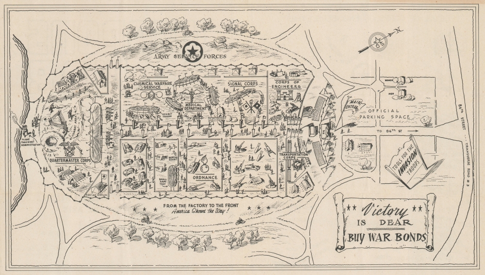
This 1944 pamphlet and map of the Army Service Forces 'Weapons of War' exhibit in New York City's Central Park was created as a souvenir for those attending the exhibit. The show (which opened less than a week after the D-Day invasion of France) set up on the Great Lawn just north of the 86th Street Transverse and was intended to drive the purchase of War Bonds and popularize the war effort. The exhibit was initially scheduled to run from June 11 to the 24th, but proved so popular, drawing some 600,000 visitors, that it was extended an extra day to the 25th before moving to Chicago. The highlight was a 'spectacular sham battle' put on by the Fighting Quartermaster's Corps. Another highlight was the flamethrower demonstration, staged every hour before a grandstand that could hold 2,500 spectators.
Describing the Pamphlet
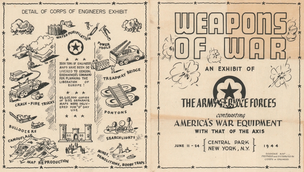
A double-sided souvenir, the front features a graphic cover claiming that the exhibit will contrast 'America's War Equipment with that of the Axis.' The verso or centerfold features a map oriented to the northwest depicting the Great Lawn, or the Oval, in Central Park. Parts of the exhibit are dedicated to different divisions within the U.S. Army, such as the Signal Corps, the Quartermaster Corps, the Corps of Engineers, Ordnance, mortars, armor, the Medical Department, and the Chemical Warfare Service. A detailed look at the Corps of Engineers exhibit appears on the back cover, and includes the piece of information that 69,602,000 copies of 3,132 separate maps were delivered for 'D' Day use. The exhibit and the overall layout, as seen here, was designed by Russel G. Matthews, a civilian consultant for the Quartermaster's Corps.Publication History and Census
This map was prepared and distributed by the Army Corps of Engineers in 1944. An example is cataloged in OCLC and is part of the collection at the New York Public Library.Condition
Very good. Some wear on original fold lines. Printed front and back.
References
OCLC 60313790.