1944 Army Corps of Engineers Pictorial Map of Grant Park, Chicago
WeaponsofWarChicago-engineers-1944-2$550.00

Title
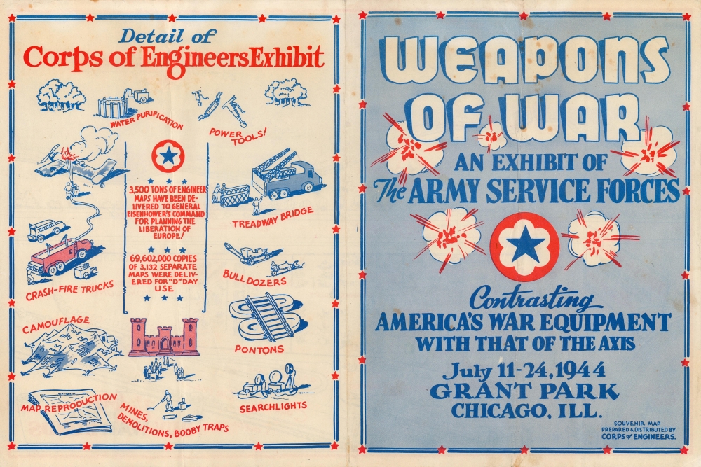
Weapons of War An Exhibit of the Army Service Forces Contrasting America's War Equipment with that of the Axis.
1944 (dated) 12 x 18 in (30.48 x 45.72 cm) 1 : 2000
1944 (dated) 12 x 18 in (30.48 x 45.72 cm) 1 : 2000
Description
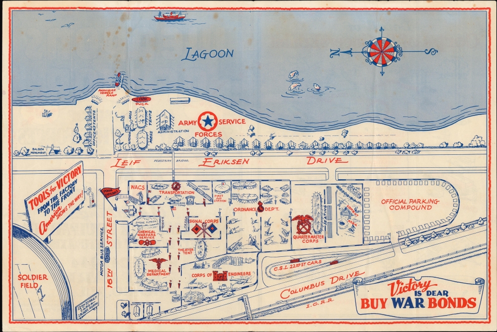
This is a 1944 Army Corps of Engineers pictorial map of the Weapons of War exhibition in Grant Park in Chicago. The exhibition was intended to display the spoils of war, rally support for the U.S. effort in the conflict, and, above all, sell war bonds.
Before installing in Grant Park, the Weapons of War exhibition had been in Central Park in New York City (for which a similar map was issued), where the highlight of the event was a 'sham battle'. A combat area, complete with seating, is included on the Grant Park map as well, implying that the battle was also part of the attraction in Chicago. Amphibious DUKWs, known as 'ducks', also appear to have been part of the exhibition; an 'amphibian vehicle ramp' is labeled along the lagoon, implying that they were at least demonstrated for the visitors. A detailed view of the Army Corps of Engineers exhibit is printed on the verso.
A Closer Look
The map depicts Grant Park from Soldier Field nearly to the intersection of Leif Eriksen Drive and Columbus Drive and from the 'lagoon' to the Illinois Central Railroad rail line running parallel to Columbus Drive. Part of the ever-present push to sell war bonds, numerous aspects of the war effort were on display. The Army Corps of Engineers made up part of the exhibition, along with the medical department, the chemical warfare service, the ordnance department (which per the map was displaying tanks and artillery pieces), and the quartermaster corps. The WACs (Women's Army Corps) and the Signal Corps were also present.Before installing in Grant Park, the Weapons of War exhibition had been in Central Park in New York City (for which a similar map was issued), where the highlight of the event was a 'sham battle'. A combat area, complete with seating, is included on the Grant Park map as well, implying that the battle was also part of the attraction in Chicago. Amphibious DUKWs, known as 'ducks', also appear to have been part of the exhibition; an 'amphibian vehicle ramp' is labeled along the lagoon, implying that they were at least demonstrated for the visitors. A detailed view of the Army Corps of Engineers exhibit is printed on the verso.
Publication History and Census
This map was prepared and distributed by the Army Corps of Engineers in 1944. It is noted among the holdings of the New York Public Library, the University of Illinois at Urbana Champaign, and the Pritzker Military Museum and Library. Both it and a map of the exhibition in New York City are ephemeral and extremely rare.Condition
Good. Creasing along fold lines. Soiling and foxing at top, especially towards left.
References
OCLC 1084734127, 60313790.