This item has been sold, but you can get on the Waitlist to be notified if another example becomes available, or purchase a digital scan.
1940 Kartenstelle Map of France and Route of German 82nd Infantry Division
Wehrmacht82ndInf-kartenstelle-1940$137.50

Title
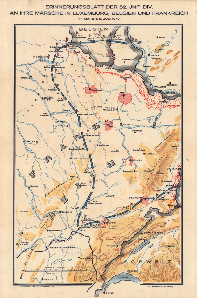
Erinnerungsblatt der 82. Jnf. Div. An Ihre Märsche in Luxemburg, Belgien, und Frankreich 17. Mai bis 9. Juli 1940.
1940 (undated) 19 x 11.75 in (48.26 x 29.845 cm) 1 : 1000000
1940 (undated) 19 x 11.75 in (48.26 x 29.845 cm) 1 : 1000000
Description
This is a c. 1940 Div. Kartenstelle route map of the Wehrmacht 82nd Infantry Division in Eastern France during World War II (1939 - 1945). While route maps following American and British units during World War II are prevalent, their German counterparts are exceedingly rare.
A Closer Look
Blue arrows illustrate the division's advance from Germany through Luxembourg and Belgium, and south through eastern France. En route, the division fought several engagements, captured Bar-le-Duc, and reached Malans on the day of the Armistice. The division then turned east and advanced through Dole, Besançon, Belfort, and Mulhouse, before crossing into Germany. Dated flags mark each day's advance.The Battle of France
The Battle of France began on May 10, 1940, when Germany invaded Belgium, Luxembourg, and the Netherlands. The battle lasted six weeks, ending on June 22, 1940, with the Second Armistice of Compiègne, signed by France and Germany. This armistice created the Occupied Zone and Unoccupied Vichy France.Publication History and Census
This map was created by Div. Kartenstelle 182 and published by Wanfried-Druck c. 1940. We have been unable to locate any other cataloged examples.Condition
Very good.