1683 Nicolas Sanson Map of West Africa
WestAfrica-sanson-1683$300.00

Title
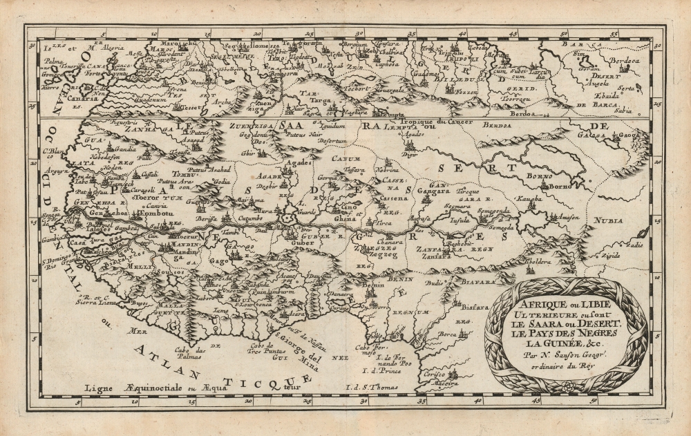
Afrique ou Libie Ulterieure ou sont Le Saara ou Desert. Le Pays des Negres La Guinée, etc. Par N. Sanson Geogr'. ordinaire du Roy.
1683 (undated) 7 x 11.25 in (17.78 x 28.575 cm) 1 : 22000000
1683 (undated) 7 x 11.25 in (17.78 x 28.575 cm) 1 : 22000000
Description
This is Nicolas Sanson's 1656 map of western Africa, reengraved for its first Dutch edition of 1683.
Sanson's small-format atlas, published in four volumes each dedicated to its own continent, had proved popular in Paris. In 1683, an edition collecting all four parts was published by Ribbius in Utrecht; the text was written by historian and exoticist Simon de Vries, and the maps were newly-engraved by Anthonie de Winter. They were faithful and skilled copies of those engraved for Sanson in Paris, to the extent of preserving the errors in those maps. For example, the present map names the islands in the Gulf of Guinea - Fernando Poo, São Tomé and Príncipe - without actually including the islands themselves. (Later states of the map can be identified in part by the correction of these lacunae.
A Closer Look
The map extends from Marrakesh in the north to Maceira and Corisco (in Gabon and Equatorial Guinea, respectively). The map includes the Canary Islands; it extends as far east as the kingdom of Nubia, beyond the imagined headwaters of the Niger River. Sanson's geographical information was notable for its divergence from Dutch cartography of the 17th-century - earlier French and Flemish mapmakers such as Tavernier and Bertius were dedicated copyists of Dutch maps, many of were out of date by decades. Hence the audience - in the Netherlands - for the maps of the Parisian Sanson. He did not entirely discard the work of Blaeu, which itself owed much to the previous century's labor of Ortelius and Gastaldi. Sanson's conflation of the Senegal River with the Niger on the present map is shared with these earlier maps. Scrutiny of the river systems on the west coast, however, shows a kinship to the geography of Livio Sanuto, whose 1588 atlas of Africa represented a unique combination of the best firsthand sources then available for the African continent. Sanuto's work had not been well-disseminated, and adopting it would have immediately set Sanson's maps apart from the rest of his contemporaries.Sanson's small-format atlas, published in four volumes each dedicated to its own continent, had proved popular in Paris. In 1683, an edition collecting all four parts was published by Ribbius in Utrecht; the text was written by historian and exoticist Simon de Vries, and the maps were newly-engraved by Anthonie de Winter. They were faithful and skilled copies of those engraved for Sanson in Paris, to the extent of preserving the errors in those maps. For example, the present map names the islands in the Gulf of Guinea - Fernando Poo, São Tomé and Príncipe - without actually including the islands themselves. (Later states of the map can be identified in part by the correction of these lacunae.
Publication History and Census
This map was initially produced in 1656 for inclusion in Sanson's L'Afrique en plusieurs cartes Nouvelles. It was re-engraved in Utrecht for inclusion in the 1683 Geographische en historische beschryvingh der vier bekende werelds-deelen Europa, Asia, Africa en America, published by Ribbius. The present example corresponds with this first, 1683 state of the map. In 1700 the maps were republished in Amsterdam by François Halma the plate would be reworked, with borders engraved more boldly, and including the missing islands of Fernando Poo et al. The atlas is well represented in institutional collections. The separate map is not listed in OCLC with reference to the Utrecht edition, but it is abundantly possible that some of the many examples listed as Paris or Amsterdam printings are misidentified.CartographerS
Nicolas Sanson (December 20, 1600 - July 7, 1667) and his descendants were the most influential French cartographers of the 17th century and laid the groundwork for the Golden Age of French Cartography. Sanson was born in Picardy, but his family was of Scottish Descent. He studied with the Jesuit Fathers at Amiens. Sanson started his career as a historian where, it is said, he turned to cartography as a way to illustrate his historical studies. In the course of his research some of his fine maps came to the attention of King Louis XIII who, admiring the quality of his work, appointed Sanson Geographe Ordinaire du Roi. Sanson's duties in this coveted position included advising the king on matters of geography and compiling the royal cartographic archive. In 1644, he partnered with Pierre Mariette, an established print dealer and engraver, whose business savvy and ready capital enabled Sanson to publish an enormous quantity of maps. Sanson's corpus of some three hundred maps initiated the golden age of French mapmaking and he is considered the 'Father of French Cartography.' His work is distinguished as being the first of the 'Positivist Cartographers,' a primarily French school of cartography that valued scientific observation over historical cartographic conventions. The practice result of the is less embellishment of geographical imagery, as was common in the Dutch Golden Age maps of the 16th century, in favor of conventionalized cartographic representational modes. Sanson is most admired for his construction of the magnificent atlas Cartes Generales de Toutes les Parties du Monde. Sanson's maps of North America, Amerique Septentrionale (1650), Le Nouveau Mexique et La Floride (1656), and La Canada ou Nouvelle France (1656) are exceptionally notable for their important contributions to the cartographic perceptions of the New World. Both maps utilize the discoveries of important French missionaries and are among the first published maps to show the Great Lakes in recognizable form. Sanson was also an active proponent of the insular California theory, wherein it was speculated that California was an island rather than a peninsula. After his death, Sanson's maps were frequently republished, without updates, by his sons, Guillaume (1633 - 1703) and Adrien Sanson (1639 - 1718). Even so, Sanson's true cartographic legacy as a 'positivist geographer' was carried on by others, including Alexis-Hubert Jaillot, Guillaume De L'Isle, Gilles Robert de Vaugondy, and Pierre Duval. More by this mapmaker...
Anthonie de Winter (1653-1707) was a Dutch engraver, etcher, publisher and art dealer. Son of Hendrik de Winter, a seal-engraver and silversmith. Little is known of his education, but it probably involved an apprenticeship to his father prior to his being made a member of the guild of St. Luke in Amsterdam, later joining the guild of booksellers as an engraver. He engraved maps for Nicolas Sanson in 1683, Jacob Lootsman in 1696, and contributed to the Vries Zee Atlas in 1698. He also engraved playing cards with Carel de Waganaer. Learn More...
Simon de Vries (1624 - 1708) was a Dutch poet, writer, historian, bookseller, publisher, and translator. De Vries had a keen eye for his readership's hunger for geographical information, and was pleased to provide it. He has been derided as a hack by later historians, mainly for the common practice of producing copious histories and travel works without having ever visited the places about which he wrote. He produced a number of books for the Utrecht publisher Ribbius, including the text for the 1683 Dutch edition of his atlas, Geographische en historische beschryvingh. Learn More...
Source
Sanson, N. / Vries, Simon de, Geographische en historische beschryvingh der vier bekende werelds-deelen Europa, Asia, Africa en America, (Utrecht: Ribbius) 1683.
Condition
Very good. Gentle marginal toning, else excellent with a sharp strike.
References
OCLC 159864677 (1700 Halma).