This item has been sold, but you can get on the Waitlist to be notified if another example becomes available, or purchase a digital scan.
1789 Sayer Map of Western Africa
WestAfrica-sayer-1789$500.00

Title
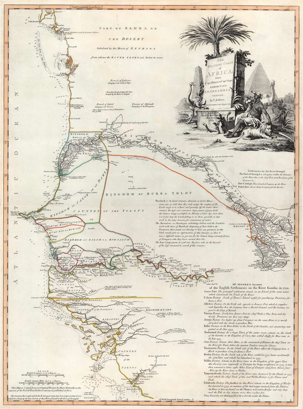
The Western Coast of Africa from Cape Blanco to Cape Vigo, Exhibiting Senegambia Proper by T. Jefferys, Geographer to His Majesty.
1789 (dated) 27.5 x 20.5 in (69.85 x 52.07 cm) 1 : 1850000
1789 (dated) 27.5 x 20.5 in (69.85 x 52.07 cm) 1 : 1850000
Description
This is a beautiful example of Robert Sayer's 1789 map of western coastal Africa. It is focused on Senegal, but includes parts of modern Mauritania, Mali, Guinea-Bissau, and Guinea. It reaches from as far north as Cap Blanco and the Arguin Banks to the mouth of the Rio Nuñez and Cap Virgo in the south. The map traces the course of the Senegal River as far east as the Felou Rocks, present site of the Félou Hydroelectric Plant in Mali.
A Closer Look
This map's geographical information is derived from D'Anville's 1751 Carte Particuliere De La Cote Occidentale De L'Afrique Depuis le Cap Blanc jusqu'au Cap De Verga et du Cours Des Rivieres De Senega et de Gambie. Nonetheless, the present Sayer map is much richer in descriptive detail - with additional data from Francis Moore's 1738 Travels into the Inland Parts of Africa. Moore worked five years in Gambia as factor for the Royal African Company, and thus D'Anville's physical geography is enhanced with cultural geography from a firsthand source.Gum Arabic
The map notes the location of forests - these specifically are forests of Gum Acacia: 'these three forests produce the Gum brought by the moors to Senegal' hence the importance of their ownership, as noted. The map's detail is most closely confined to the rivers, which represented the sole means of accessing the interior available to Europeans. The courses of the Senegal River and the Gambia are thus particularly well detailed. This region was the primary focus of France's efforts to colonize in Africa, both in terms of controlling the world's supply of Gum Arabic and attempting to enter the international slave trade. The evidence of these efforts began to appear cartographically as early as 1707 with the maps of De Fer, and in those of Guillaume de l'Isle - but D'Anville's treatment showed the area with much more accuracy.Factories on the Gambia
Francis Moore's reports focused mainly on the English efforts to trade on the Gambia River, and notes from those reports are included here. The Africa Company maintained factories all along the river in order to administer and control trade, both to provision the main post at James Fort, and for trade both with England and the Americas. The company paid local kingdoms to maintain these posts. The notes indicate the trade goods available from each - often provisions, but also wax and ivory for trade, as well as slaves. Factories that were eventually abandoned or destroyed are also noted. The map also marks the presence of gold in the upper Senegal River, and discusses the native efforts to gather it, and control its trade.A Dramatic Cartouche
Jefferys' cartouche presents the title of the map and its imprint on a great stone stele, entwined with vines and shadowed with a palm tree. About this monolith are ranged a crocodile and an ostrich, threatening snakes, a glowering lion and a long-necked camel. A Black woman, an allegorical representation of the continent, is seated next to the lion, improbably wearing the head of an elephant as a headdress. In the background are depictions of the Egyptian pyramids, despite the location of those monuments and the area here mapped being separated by the entirety of northern Africa (a distinction perhaps unimportant to the British reader at the time).Publication History and Census
This map was engraved by Thomas Jefferys in 1768 for inclusion in his atlas. When Jefferys' firm was inherited by Robert Sayer, the map's imprint was amended. We see about a dozen examples cataloged in institutional collections.CartographerS
Robert Sayer (1725 - January 29, 1794) was an important English map publisher and engraver active from the mid to late 18th century. Sayer was born in Sunderland, England, in 1725. He may have clerked as a young man with the Bank of England, but this is unclear. His brother, James Sayer, married Mary Overton, daughter-in-law of John Overton and widow of Philip Overton. Sayer initially worked under Mary Overton, but by December of 1748 was managing the Overton enterprise and gradually took it over, transitioning the plates to his own name. When Thomas Jefferys went bankrupt in 1766, Sayer offered financial assistance to help him stay in business and, in this way, acquired rights to many of the important Jefferys map plates as well as his unpublished research. From about 1774, he began publishing with his apprentice, John Bennett (fl. 1770 - 1784), as Sayer and Bennett, but the partnership was not formalized until 1777. Bennett retired in 1784 following a mental collapse and the imprint reverted to Robert Sayer. From 1790, Sayer added Robert Laurie and James Whittle to his enterprise, renaming the firm Robert Sayer and Company. Ultimately, Laurie and Whittle partnered to take over his firm. Sayer retired to Bath, where, after a long illness, he died. During most of his career, Sayer was based at 53 Fleet Street, London. His work is particularly significant for its publication of many British maps relating to the American Revolutionary War. Unlike many map makers of his generation, Sayer was a good businessman and left a personal fortune and great estate to his son, James Sayer, who never worked in the publishing business. More by this mapmaker...
Thomas Jefferys (1695 - November 20, 1771) was one of the most prominent and prolific map publishers and engravers of his day. Jefferys was born in Birmingham and was apprenticed to the engraver Emmanuel Bowen in 1735. Later, in the 1740s he engraved several maps for the popular periodical Gentleman's Magazine. Around 1740 Jefferys was finally able to go into business for himself and in 1746 received an appointment as 'Geographer to Fredrick, Prince of Wales,' which shortly after translated to the position of 'Royal Cartographer to King George III.' Jefferys initially specialized in compiling and re-engraving the works of earlier cartographers into more coherent cartographic wholes. Later, while not salaried position, Jefferys' appointment as 'Royal Cartographer' guaranteed preferential access to the most up to date cartographic material available, allowing him to produce new and updated charts of exceptional accuracy. He his best known for his maps of the Americas, particularly the posthumously published 1775 American Atlas, which included some of the finest and most important late colonial era maps of America ever made. Despite his prolific publishing history, royal appointments, and international publishing fame, Jefferys lived most of his life in dire economic straits. He was bailed out of bankruptcy by Robert Sayer during the production of the American Atlas. In the end, Jefferys died suddenly with very little to his name. Nonetheless, his cartographic legacy survived, and even after his death in 1771, many of his important maps continued to be published and republished by Sayer and Bennet, Conrad Lotter, Georges Louis Le Rouge, Laurie and Whittle, and others. Many attribute some of Jefferys best maps to the colorful and criminally inclined Irish cartographic genius Braddock Mead (John Green, c. 1688 - 1757), who is considered the 'secret behind Jefferys.' Jefferys was succeeded by his son, also Thomas, who had little success as a cartographer and eventually partnered with, then sold his stock and plates to William Faden - Jefferys' true heir. Learn More...
Jean Baptiste Bourguignon d'Anville (1697 - 1782) was perhaps the most important and prolific cartographer of the 18th century. D'Anville's passion for cartography manifested during his school years when he amused himself by composing maps for Latin texts. There is a preserved manuscript dating to 1712, Graecia Vetus, which may be his earliest surviving map - he was only 15 when he drew it. He would retain an interest in the cartography of antiquity throughout his long career and published numerous atlases to focusing on the ancient world. At twenty-two D'Anville, sponsored by the Duke of Orleans, was appointed Geographer to the King of France. As both a cartographer and a geographer, he instituted a reform in the general practice of cartography. Unlike most period cartographers, D'Anville did not rely exclusively on earlier maps to inform his work, rather he based his maps on intense study and research. His maps were thus the most accurate and comprehensive of his period - truly the first modern maps. Thomas Basset and Philip Porter write: "It was because of D'Anville's resolve to depict only those features which could be proven to be true that his maps are often said to represent a scientific reformation in cartography." (The Journal of African History, Vol. 32, No. 3 (1991), pp. 367-413). In 1754, when D'Anville turned 57 and had reached the height of his career, he was elected to the Academie des Inscriptions. Later, at 76, following the death of Philippe Buache, D'Anville was appointed to both of the coveted positions Buache held: Premier Geographe du Roi, and Adjoint-Geographer of the Academie des Sciences. During his long career D'Anville published some 211 maps as well as 78 treatises on geography. D'Anville's vast reference library, consisting of over 9000 volumes, was acquired by the French government in 1779 and became the basis of the Depot Geographique - though D'Anville retained physical possession his death in 1782. Remarkably almost all of D'Anville's maps were produced by his own hand. His published maps, most of which were engraved by Guillaume de la Haye, are known to be near exact reproductions of D'Anville' manuscripts. The borders as well as the decorative cartouche work present on many of his maps were produced by his brother Hubert-Francois Bourguignon Gravelot. The work of D'Anville thus marked a transitional point in the history of cartography and opened the way to the maps of English cartographers Cary, Thomson and Pinkerton in the early 19th century. Learn More...
Francis Moore (c. 1708 - c. 1756) was a British traveler and writer, and one of the first Englishmen to travel to the African interior. He had been employed as a clerk for the Royal African Company, and was sent to the company's factory at the Gambia River in 1730 where he became the company's factor. He stayed until 1735. He is best known for his 1738 Travels into the Inland Parts of Africa, in which he recorded the observations of his travels; this short book details the cultural geography of West Africa just prior to the 18th century intensification of the Atlantic slave trade. It is the only account of Gambia prior to the colonial period.
Following his time in Africa, Moore sailed to Georgia as part of Oglethorpe's colonial effort there; he served as Oglethorpe's secretary, and a storekeeper at Fort Frederica. As with his Africa voyage, Moore published his observations in A Voyage to Georgia. Learn More...
Source
Kitchin, T., Kitchin's A New Universal Atlas, (London: Kitchin), 1789.
Condition
Excellent. Complete margins. Original outline color.
References
OCLC 24889057. Rumsey 2310.075. Afriterra 312.