This item has been sold, but you can get on the Waitlist to be notified if another example becomes available.
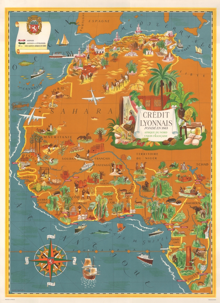
1956 Lucien Boucher Art Deco Pictorial Map of West Africa
WestAfricaCreditLyonnais-boucher-1956$600.00


Title
Crédit Lyonnais. Fondé en 1863. Afrique du Nord et Union Française.
1956 (undated) 39.5 x 28.75 in (100.33 x 73.025 cm) 1 : 5850000
1956 (undated) 39.5 x 28.75 in (100.33 x 73.025 cm) 1 : 5850000
Description
This is a c. 1956 Lucien Boucher art deco pictorial map of the Maghreb and West Africa highlighting Crédit Lyonnais banks. The map reflects the work of one of the greatest pictorial map makers of the mid-20th century. Moreover, it illustrates French Africa at the beginning of its decline as a political power.
A Closer Look
Banners mark cities in North Africa and West Africa where Crédit Lyonnais operated banks, including Casablanca, Oran, Algiers, Tunis, Dakar, Abidjan, Douala, Yaoundé, and Brazzaville. Pictorial vignettes illustrate stereotypical views of North and West Africa, including camel caravans, oases, and African animals. A decorative title cartouche features a North African woman weaving a blanket and a West African man holding a bunch of bananas near a sack of cacao.Dating The Map
This map is dated c. 1960 in institutional collections and on the private market. However, as is pointed out in the catalog entry at the Bibliothèque nationale de France, the French Union lasted from 1946 until 1958, when it was replaced with the French Community by Charles de Gaulle's Fifth Republic. We have thus opted for a c. 1956 date.Historical Context - the Union française
The Union française or French Union in Africa (1946 - 1958) was a political and economic association between France and its former colonies in Africa. It was established after World War II (1939 - 1945) to maintain France's influence in the region. The French Union granted its member countries some autonomy in internal affairs, but maintained control over their foreign policy, defense, and currency. This relationship was marked by a complex mix of cooperation and domination, with France often intervening in the affairs of its former colonies and using its military and economic leverage. The French Union was dissolved in 1858 as many African countries gained independence.Publication History and Census
This map was created by Lucien Boucher for Crédit Lyonnais c. 1956. It was printed in Paris by Parceval. We note cataloged examples as being part of the collection at the Bibliothèque nationale de France and the David Rumsey. It occasionally appears on the private market.Cartographer
Lucien Boucher (1889 - 1971) was French cartoonist, artist, writer, and illustrator. Boucher was born in Chartres in 1889 and graduated from the École de Céramique de Sèvres. His work as a cartoonist appeared in the humorous weekly Le Rire. Starting in the 1920s he produced numerous pictorial posters inspired by the commercial promise of surrealism. Among them were a series of surrealistic planispheric and celestial maps drawn to illustrate the transportation networks of Air France. More by this mapmaker...
Condition
Very good. Mounted on heavy linen.
References
Rumsey 8464.000.