This item has been sold, but you can get on the Waitlist to be notified if another example becomes available, or purchase a digital scan.
1840 Wyld Map of the Coast of West Africa
WesternCoastAfrica-wyld-1840$237.50

Title
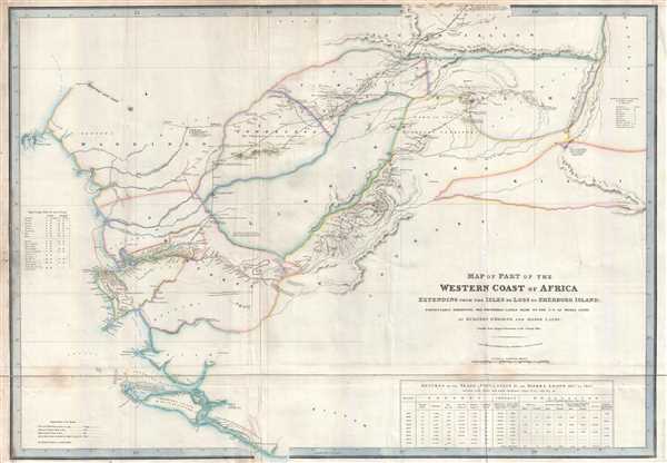
Map of Part of the Western Coast of Africa Extending from the Isles de Loss to Sherboro Island. Particularly Exhibiting the Discoveries Lately Made to the N.E. of Sierra Leone by Surveon O'Beirne and Major Laing.
1840 (dated) 26 x 37 in (66.04 x 93.98 cm) 1 : 570000
1840 (dated) 26 x 37 in (66.04 x 93.98 cm) 1 : 570000
Description
This is an 1840 James Wyld map of West Africa. The map depicts the western coast of Africa from the Iles de Los and Guinea to Sherbro Island and Sierra Leone. One of the best known early maps of the British Colony of Sierra Leone, the duality between the meticulously charted coastline (the work of the Royal Navy) and the almost completely blank interior acts as a visual summary of European knowledge of and interest in Africa. The only detailed regions of the interior are those traversed by British explorers. The routes of four different expeditions into the interior are illustrated: the route followed by Thomas Masterman Winterbottom in 1794, the route of Surgeon Brian O'Beirne's 1821 expedition, the routes of both of Major Alexander Gordon Laing's 1822 expeditions, and the route of Jack le Boré's 1822 expedition. Numerous towns, villages, and other settlements in the region are noted and labeled, along with rivers, lakes, mountains, and other physical features. Numerous notes concerning the region are also included. A very interesting table, entitled 'Returns of the Trade Population etc. of Sierra Leone 1817 to 1825' is situated in the lower right corner. Two columns in the table list the number of liberated Africans living in the colony by gender.
Sierra Leone in the British Empire
Sierra Leone held a unique position in the British Empire because it was founded as a refuge for ex-slaves following the British abolition of the slave trade in 1807. Freetown was founded in 1792 by the British Sierra Leone Company and expanded drastically following the 1807 ban and the naval base at Freetown was expanded in an effort to combat the slave trade. British officials also instituted an 'apprentice system' for ex-slaves, supposedly employing them with European settlers based on their skillset. In reality, that is not what happened. Former slaves were assigned to apprenticeships without regard for their strengths. For example, an individual without any experience working in the fields would be assigned to work as a farm hand, while experienced farm workers would be assigned to craft workshops where they had no experience. The system quickly devolved into slavery in everything but name, as apprentices could not leave or change jobs without their employer's consent and were paid nothing close to a living wage. While some experienced improvement in living conditions, 'the apprenticeship system revealed itself to be patronizing and misguided'.
This map was created by James Wyld and published in 1840.
Cartographer
Wyld (1823 - 1893) was a British publishing firm active throughout the 19th century. It was operated by James Wyld I (1790 - 1836) and his son James Wyld II (November 20, 1812 - 1887) were the principles of an English mapmaking dynasty active in London during much of the 19th century. The elder Wyld was a map publisher under William Faden (1749 - 1836) and did considerable work on the Ordinance Survey. On Faden's retirement in 1823, Wyld took over Faden's workshop, acquiring many of his plates. Wyld's work can often be distinguished from his son's maps through his imprint, which he signed as 'Successor to Faden'. Following in his father's footsteps, the younger Wyld joined the Royal Geographical Society in 1830 at the tender age of 18. When his father died in 1836, James Wyld II was prepared to fully take over and expand his father's considerable cartographic enterprise. Like his father and Faden, Wyld II held the title of official Geographer to the Crown, in this case, Queen Victoria. In 1852, he moved operations from William Faden's old office at Charing Cross East (1837 - 1852) to a new, larger space at 475 Strand. Wyld II also chose to remove Faden's name from all of his updated map plates. Wyld II continued to update and republish both his father's work and the work of William Faden well into the late 1880s. One of Wyld's most eccentric and notable achievements is his 1851 construction of a globe 19 meters (60 feet) in diameter in the heart of Leicester Square, London. In the 1840s, Wyld also embarked upon a political career, being elected to parliament in 1847 and again in 1857. He died in 1887 following a prolific and distinguished career. After Wyld II's death, the family business was briefly taken over by James John Cooper Wyld (1844 - 1907), his son, who ran it from 1887 to 1893 before selling the business to Edward Stanford. All three Wylds are notable for producing, in addition to their atlas maps, short-run maps expounding upon important historical events - illustrating history as it was happening - among them are maps related to the California Gold Rush, the New South Wales Gold Rush, the Scramble for Africa, the Oregon Question, and more. More by this mapmaker...
Condition
Very good. Backed on archival tissue for stability. Blank on verso.
References
Afriterra 43.