This item has been sold, but you can get on the Waitlist to be notified if another example becomes available, or purchase a digital scan.
1787 Bonne Map of the Mississippi Valley or 'Western United States'
WesternUS-bonne-1787$175.00

Title
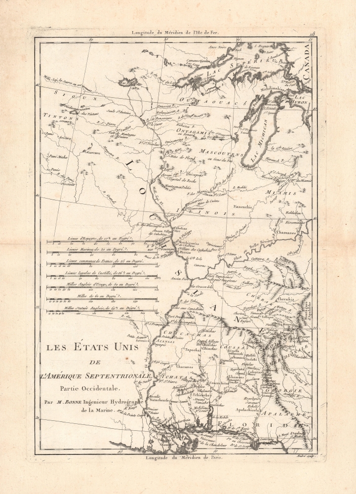
Les Etats Unis de L'Amerique Septentrionale, Partie Occidentale.
1787 (undated) 13.75 x 9.25 in (34.925 x 23.495 cm) 1 : 6100000
1787 (undated) 13.75 x 9.25 in (34.925 x 23.495 cm) 1 : 6100000
Description
A detailed c. 1787 Rigobert Bonne map of the western part of the 'United States of North America', essentially the land between the Mississippi River and the Appalachian Mountains. It is significant for its recognition of the United States, which is early for a map of this type, as well as for its detailed cataloging of Native American groups on the American frontier.
It is worth remembering that when this map was published Louisiana remained French, and its (ill defined) borders did not exactly correspond to the future Louisiana Territory, explaining the placement of 'Louisiane' here. That being said, the French forts shown here along the Mississippi River were abandoned either before or during the Seven Years' War and French settlers encouraged to move west of the river. St. Louis, which was just emerging at this time as a major trade center on the Mississippi River, is not noted, though nearby 'Cahokias' and a fort (Fort de Chartres) are.
A Closer Look
Significant for its use of the 'United States of North America' in its title, this map focuses on the lands between the Mississippi River and the coastal areas of the new republic, where most of its non-indigenous population lived. Consequently, Bonne details the many Native American groups present in these lands, who were already being pressed by American settlers moving westwards. Rivers, lakes, mountains, settlements, forts, missions, and resources (saline, crystal de roche, etc.) are also noted. Seven different scales are arranged at left for reference.Territorial Uncertainties
At the end of the Seven Years' War (1756-1763), also known as the French and Indian War, King George III forbade colonial settlement west of the Appalachian Mountains (and east of the Mississippi River), which was set aside as an Indian Reserve. However, during the Revolutionary War and the early history of the American Republic, the new states often claimed territory extending all the way to the Mississippi River, despite the minimal presence, if any, of American settlers there. Overlapping claims arose and the borders between states were unclear, leading to disputes. However, by 1787, the federal government had acquired control over many of these disputed lands in order to formally designate them as territories, with the largest being the Northwest Territory, the future states of Ohio, Indiana, Illinois, Michigan, and Wisconsin.It is worth remembering that when this map was published Louisiana remained French, and its (ill defined) borders did not exactly correspond to the future Louisiana Territory, explaining the placement of 'Louisiane' here. That being said, the French forts shown here along the Mississippi River were abandoned either before or during the Seven Years' War and French settlers encouraged to move west of the river. St. Louis, which was just emerging at this time as a major trade center on the Mississippi River, is not noted, though nearby 'Cahokias' and a fort (Fort de Chartres) are.
Publication History and Census
This map was drawn by Rigobert Bonne and engraved by André as Plate No. 118 for Bonne and Nicolas Desmarest's Atlas Encyclopedique, published between 1787 and 1788. It is independently cataloged by 17 institutions worldwide in the OCLC, while the entire Atlas Encyclopedique is more widely distributed.Cartographer
Rigobert Bonne (October 6, 1727 - September 2, 1794) was one of the most important French cartographers of the late 18th century. Bonne was born in Ardennes à Raucourt, France. He taught himself mathematics and by eighteen was a working engineer. During the War of the Austrian Succession (1740 - 1748) he served as a military engineer at Berg-op-Zoom. It the subsequent years Bonne became one of the most respected masters of mathematics, physics, and geography in Paris. In 1773, Bonne succeeded Jacques-Nicolas Bellin as Royal Cartographer to France in the office of the Hydrographer at the Depôt de la Marine. Working in his official capacity, Bonne compiled some of the most detailed and accurate maps of the period - most on an equal-area projection known erroneously as the 'Bonne Projection.' Bonne's work represents an important step in the evolution of the cartographic ideology away from the decorative work of the 17th and early 18th century towards a more scientific and practical aesthetic. While mostly focusing on coastal regions, the work of Bonne is highly regarded for its detail, historical importance, and overall aesthetic appeal. Bonne died of edema in 1794, but his son Charles-Marie Rigobert Bonne continued to publish his work well after his death. More by this mapmaker...
Source
Bonne, Rigobert and Desmarest, N., Atlas encyclopédique contenant la géographie ancienne, et quelques cartes sur la géographie du moyen age, la geographie moderne, et les cartes relatives a la géographie physique, (Paris) 1787-1788.
Condition
Very good. Toning along fold line and in margins. Light offsetting.
References
OCLC 5401784, 431584577, 643748704.