1843 Wyld Map and Chart of the West Indies
WestIndies-wyld-1843$800.00
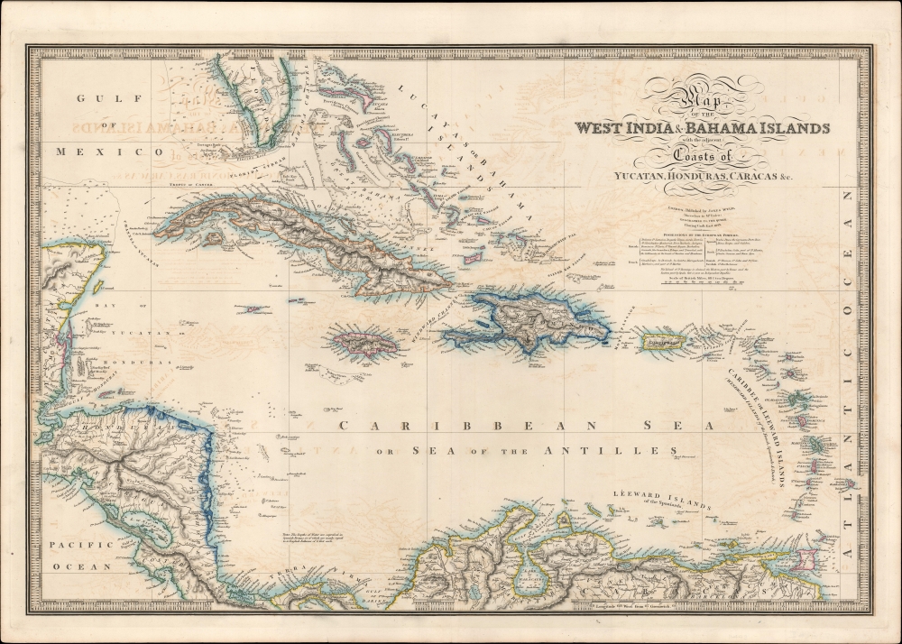


Title
Map of the West India and Bahama Islands with the adjacent Coasts of Yucatan, Honduras, Caracas etc.
1843 (dated) 20.5 x 30.75 in (52.07 x 78.105 cm) 1 : 4320000
1843 (dated) 20.5 x 30.75 in (52.07 x 78.105 cm) 1 : 4320000
Description
A beautifully engraved 1843 map and nautical chart of the West Indies or Caribbean by James Wyld, 'Geographer to the Queen.' It captures the region in a moment of transition, as plantation slavery in the British colonies began to be dismantled and revolution and rebellion destabilized island economics.
A series of slave revolts occurred in the West Indies in the 1820s-1830s, including Bussa's Rebellion on Barbados (1816), the Baptist War on Jamaica (1831 - 1832), and Nat Turner's Rebellion (1831), that hastened the abolition of slavery in several European colonial empires. Of the empires shown here, the British abolished slavery in 1833 and the Spanish colonies largely abolished slavery upon independence, although while slavery remained practiced on Puerto Rico and Cuba until the 1870s - 1880s. The French abolished slavery in their empire (for the third time) in 1848, the Dutch in 1860 - 1863, the Danish in 1848, and the Swedish, with a single colony at Saint Barthélemy (here as St. Bartholomew), in the mid-1840s.
The abolition of slavery did not end unfree labor, as the process was often gradual and colonial governments were more concerned with compensating plantation owners than ensuring the livelihood of newly emancipated people. For instance, on Jamaica, emancipated slaves were initially forced to 'apprentice' for their former owners for several years. Inequality was extreme and former slaveowners sought creative methods to reinstitute slavery in all but name, even though the plantation economy was clearly becoming unviable for reasons besides emancipation. Continuing racial tensions and heavy-handed administration by the white elite led to violence, as with the Morant Bay rebellion in 1865.
A Closer Look
Coverage stretches from South Florida (including 'Lake Mayaco,' that is, Lake Okeechobee) to the northern coast of South America and takes in much of Central America. Territories are outlined in hand color, with partial consistency according to their colonial empire (a list of islands and their European claimants is included under the title). Mountains, waterways, and settlements are recorded on land, while soundings (in Spanish brazas), hazards, islets, banks, passages between islands, and ocean currents are indicated on water. Additional information is provided in brief notes, such as recently discovered shoals and known anchorages. An intricate border marks out longitude and latitude.The Decline of Plantation Slavery
Although European outposts on Caribbean islands had strategic military value, they primarily slave economies driven by sugar and tobacco. Along with economic factors, by the late 18th century the growing Transatlantic abolitionist movement and the Age of Revolutions, particularly the Haitian Revolution, signaled that the days of slave trading were numbered. Between 1780 and 1820, most European empires and the United States banned the slave trade, though the abolition of slavery itself usually lagged. This lag period was especially fraught, as the established economic order had a clear interest in maintaining slavery, while enslaved people and free people of color pressed for more immediate abolition. Slave uprisings, particularly the Haitian Revolution (1791 - 1804), terrified plantation owners, who invested heavily in 'security' and often became more stubborn in their commitment to plantation slavery as a result, further heightening tensions.A series of slave revolts occurred in the West Indies in the 1820s-1830s, including Bussa's Rebellion on Barbados (1816), the Baptist War on Jamaica (1831 - 1832), and Nat Turner's Rebellion (1831), that hastened the abolition of slavery in several European colonial empires. Of the empires shown here, the British abolished slavery in 1833 and the Spanish colonies largely abolished slavery upon independence, although while slavery remained practiced on Puerto Rico and Cuba until the 1870s - 1880s. The French abolished slavery in their empire (for the third time) in 1848, the Dutch in 1860 - 1863, the Danish in 1848, and the Swedish, with a single colony at Saint Barthélemy (here as St. Bartholomew), in the mid-1840s.
The abolition of slavery did not end unfree labor, as the process was often gradual and colonial governments were more concerned with compensating plantation owners than ensuring the livelihood of newly emancipated people. For instance, on Jamaica, emancipated slaves were initially forced to 'apprentice' for their former owners for several years. Inequality was extreme and former slaveowners sought creative methods to reinstitute slavery in all but name, even though the plantation economy was clearly becoming unviable for reasons besides emancipation. Continuing racial tensions and heavy-handed administration by the white elite led to violence, as with the Morant Bay rebellion in 1865.
Publication History and Census
Editions of this map appeared between at least 1825 and 1851, though the present edition is unrecorded in the OCLC and the only other known example is held by the Huntington Library. It appeared as on optional supplementary plate in Wyld's A New General Atlas of Modern Geography, variously dated 1842 - 1844 or 1844 (tentatively), which is held in its entirety by the Library of Congress, Rice University, the University of Southern Maine, and the State Library of Western Australia.Cartographer
Wyld (1823 - 1893) was a British publishing firm active throughout the 19th century. It was operated by James Wyld I (1790 - 1836) and his son James Wyld II (November 20, 1812 - 1887) were the principles of an English mapmaking dynasty active in London during much of the 19th century. The elder Wyld was a map publisher under William Faden (1749 - 1836) and did considerable work on the Ordinance Survey. On Faden's retirement in 1823, Wyld took over Faden's workshop, acquiring many of his plates. Wyld's work can often be distinguished from his son's maps through his imprint, which he signed as 'Successor to Faden'. Following in his father's footsteps, the younger Wyld joined the Royal Geographical Society in 1830 at the tender age of 18. When his father died in 1836, James Wyld II was prepared to fully take over and expand his father's considerable cartographic enterprise. Like his father and Faden, Wyld II held the title of official Geographer to the Crown, in this case, Queen Victoria. In 1852, he moved operations from William Faden's old office at Charing Cross East (1837 - 1852) to a new, larger space at 475 Strand. Wyld II also chose to remove Faden's name from all of his updated map plates. Wyld II continued to update and republish both his father's work and the work of William Faden well into the late 1880s. One of Wyld's most eccentric and notable achievements is his 1851 construction of a globe 19 meters (60 feet) in diameter in the heart of Leicester Square, London. In the 1840s, Wyld also embarked upon a political career, being elected to parliament in 1847 and again in 1857. He died in 1887 following a prolific and distinguished career. After Wyld II's death, the family business was briefly taken over by James John Cooper Wyld (1844 - 1907), his son, who ran it from 1887 to 1893 before selling the business to Edward Stanford. All three Wylds are notable for producing, in addition to their atlas maps, short-run maps expounding upon important historical events - illustrating history as it was happening - among them are maps related to the California Gold Rush, the New South Wales Gold Rush, the Scramble for Africa, the Oregon Question, and more. More by this mapmaker...
Source
Wyld, J., A New General Atlas of Modern Geography consisting of a Complete Collection of Maps of the Four Quarters of the Globe, (London: J. Wyld) c. 1844.
Condition
Very good. Noticeable offsetting. A few small creases and tears along edge.
References
Huntington Library Call Number 105:957 M. OCLC (entire atlas) 221659972, 39273371.