1974 Dansbury Wall Map of Wilkes-Barre and Wyoming Valley, Pennsylvania
WilkesBarre-dansbury-1974$175.00


Title
Wilkes-Barre Center of the Third Largest Market In Pennsylvania the Country's Outstanding Industrial State.
1974 (undated) 16 x 43 in (40.64 x 109.22 cm) 1 : 26000
1974 (undated) 16 x 43 in (40.64 x 109.22 cm) 1 : 26000
Description
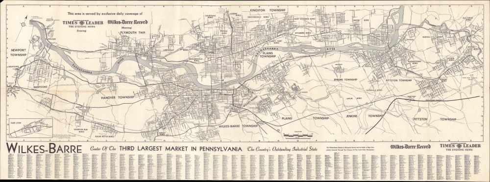
This is a 1974 Cornelius W. Dansbury large-format map of Wilkes-Barre, Pennsylvania, and surrounding communities in the Wyoming Valley, printed for the local newspapers the Times Leader and the Wilkes-Barre Record.
When this map was prepared, Wilkes-Barre and nearby communities in Northeastern Pennsylvania were undergoing deindustrialization, in particular the decline of the anthracite coal mining industry, which had been the mainstay of the region's economy in earlier years. Wilkes-Barre also suffered badly from flooding in 1972 due to Hurricane Agnes. Afterward, the city spent decades elaborating a levee system that has prevented similar floods despite equally severe storms in the intervening years.
A Closer Look
Oriented towards the northwest so as to make the Susquehanna River roughly horizontal, the map covers Wilkes-Barre and environs, as far west as Sheatown and Glen Lyon (in an inset at bottom-left) and as far east as Moosic and the Wilkes-Barre Scranton International Airport. Local roads and highways are labeled throughout, with the former being listed in an index at bottom. Townships and boros are named, while railroads, bridges, airports (the Wilkes-Barre Wyoming Valley Airport in addition to the international airport), and other features are indicated.When this map was prepared, Wilkes-Barre and nearby communities in Northeastern Pennsylvania were undergoing deindustrialization, in particular the decline of the anthracite coal mining industry, which had been the mainstay of the region's economy in earlier years. Wilkes-Barre also suffered badly from flooding in 1972 due to Hurricane Agnes. Afterward, the city spent decades elaborating a levee system that has prevented similar floods despite equally severe storms in the intervening years.
Publication History and Census
This map was prepared by Cornelius Wesley Dansbury and printed in 1974 for the local newspapers, the Times Leader and the Wilkes-Barre Record to reflect their distribution area. It appears to be a second edition of an earlier c. 1950 map produced by Dansbury when he was with the Dansbury-Hill Advertising Company. Regardless of edition, the map is quite scarce, only being held by Pennsylvania State University and the Library of Congress.Cartographer
Cornelius Wesley Dansbury (February 15, 1905 - December 16, 1979), often working as C. W. Dansbury or C. Wes. Dansbury (perhaps to distinguish him from his father, of the same name), was a cartographer based in Trenton, New Jersey. Details of his early life are scant, but he may have been a schoolteacher before being drafted into the U.S. Army during the Second World War. During the war, in 1943, he married Charlotte Zweigle and together they had one child. Perhaps due to experience gained in the military, Dansbury began producing maps in the postwar period, focusing mainly on his native Trenton and neighboring parts of New Jersey and eastern Pennsylvania; roughly thirty maps are cataloged in the OCLC under various renderings of his name. Dansbury also compiled a street directory for Trenton in 1951 and was seemingly the co-owner of the Dansbury-Hill Advertising Company, based in Trenton and active c. 1948 - 1952. More by this mapmaker...
Condition
Very good. Light wear along original fold lines. Verso repairs to a fold separation. Closed margin tear professionally repaired on verso. Very close bottom margin.
References
OCLC 5439937.