This item has been sold, but you can get on the Waitlist to be notified if another example becomes available, or purchase a digital scan.
1886 Lester and Williams Map of Woodstock, Connecticut
WoodstockConn-lesterwilliams-1886$250.00

Title
Map of Woodstock, Conn.
1886 (dated) 24.5 x 28 in (62.23 x 71.12 cm) 1 : 21120
1886 (dated) 24.5 x 28 in (62.23 x 71.12 cm) 1 : 21120
Description
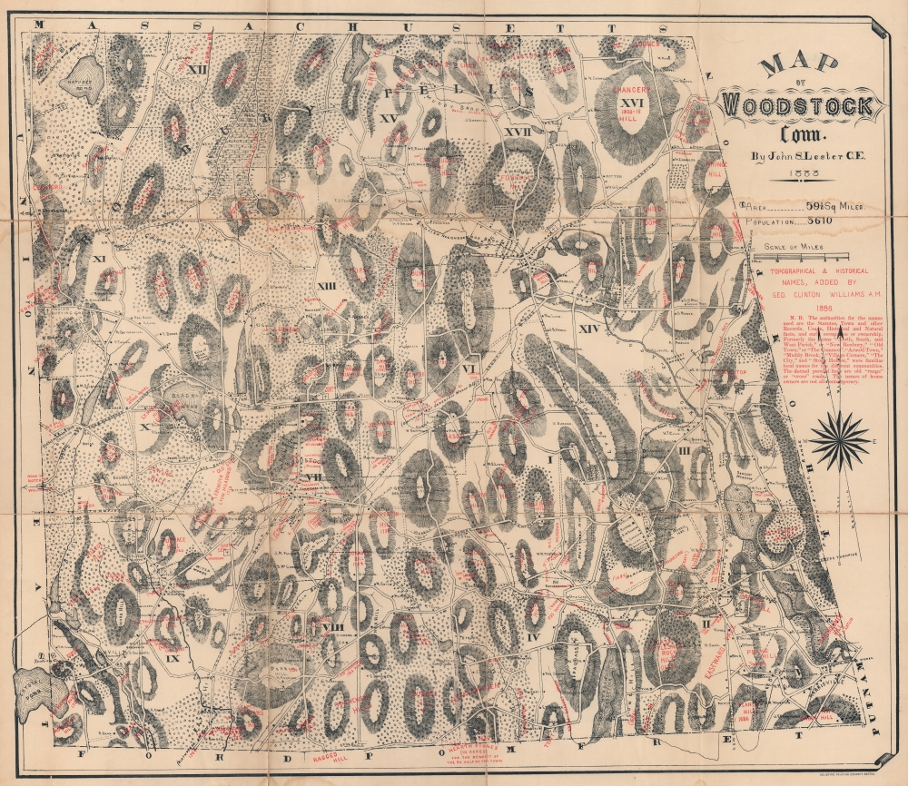
This 1886 John Lester and George Clinton Williams map of Woodstock, Connecticut combines historical content with contemporary homesteads and businesses. Situated in northeastern Connecticut, Woodstock was settled in 1686 and officially named in 1690.
A Closer Look
Lester's black text identifying contemporary sites juxtaposed with Williams' red text labeling topographic features and historic locations creates an intriguing dichotomy. Lester marks individual residences throughout, along with meadows, ponds, and hills. He also divides the town into precincts and notes fairgrounds, churches, cemeteries, and at least two Indian burial grounds. Williams' additions label old cemeteries, specific hills (which Lester does sparingly even if he illustrates them all), meadows, old tanneries, and old cemeteries.Publication History and Census
This map was created by John S. Lester and originally published in 1883. In 1886 George Clinton Williams annotated the map, adding topographical and historical names (all in red overprinting) and printed by the Heliotype Printing Company. This map is well represented in institutional collections.CartographerS
George Clinton Williams (September 5, 1825 - 1901) was born in West Woodstock, Connecticut. He attended Yale College and graduated in 1847, then studied law with his father (who was a judge) and in 1849 was admitted to the bar. He worked in the Naval and Treasury Departments in Washington, D.C. for a few years and then became solicitor and chief of the organization division of the Bureau of National Currency in 1867. After his time in the Bureau of National Currency he served as the brigade quartermaster and inspector on General Elihu Geer's staff. In 1886, he annotated John S. Lester's map of Woodstock, Connecticut, with topographical and historical names. More by this mapmaker...
The Heliotype Printing Company (1872 - c. 1900) was a printing company based in Boston. The company was promoted as 'artistic printers by the best photogelatine and photolithographic processes.' They were reorganized in 1885, adapting chromolithographic and photo reprographic techniques. They remained active until at least the 1930s. Their offices were located at 211 Tremont Street, Boston. Learn More...
Condition
Average. Mounted on linen. Wear along original fold lines. A few unrepaired splits to old linen. Dampstaining.
References
OCLC 5473776.