1811 Yeakell Map or Plan of the Ordnance Grounds at Woolwich, London, England
Woolwich-yeakell-1811$300.00

Title
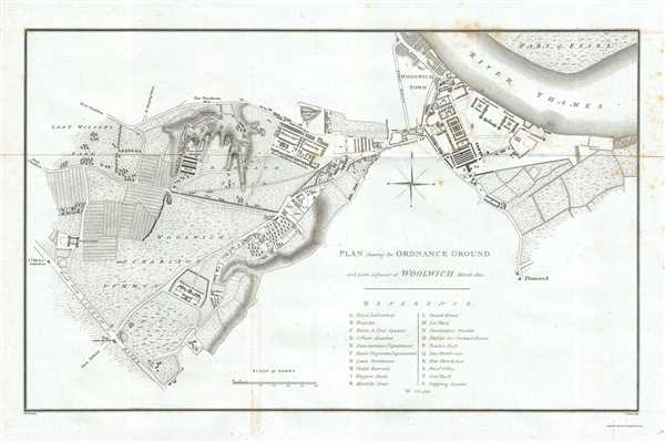
Plan shewing the Ordnance Ground and parts adjacent at Woolwich March 1810.
1811 (dated) 13.5 x 21 in (34.29 x 53.34 cm) 1 : 8100
1811 (dated) 13.5 x 21 in (34.29 x 53.34 cm) 1 : 8100
Description
This is a scarce 1811 map or plan of Woolwich and vicinity, London published by T. Cadell and W. Davies. The plan is highly detailed, noting individual buildings, roads with beautifully rendered topography. It depicts the ordnance grounds around Woolwich town, including the Military Academy, Ordnance Wharf, Foot Artillery Barracks, Horse Artillery Barracks, Repository Grounds, etc. Woolwich Town is also noted. A key below the title lists the various locations marked on the map.
Woolwich originally known as Woolwich Saitn Mary, was a small Kentish village in south east London before it became a military and naval town. The Royal Military Academy dates back to 1741 while the Royal Arsenal which houses the Royal Artillery Museum, dates back to 1671. Till date, the town of Woolwich remains an army base.
This map was drawn by Thomas Yeakell and engraved by J. Warner. Published in 1811 by T. Cadell and W. Davies.
Condition
Very good. Minor toning and wear along original fold lines. Some foxing at places, especially in top right quadrant.
References
OCLC: 557959609.