This item has been sold, but you can get on the Waitlist to be notified if another example becomes available, or purchase a digital scan.
1841 Olney Polar Projection Map of the World
World-olney-1841$90.00

Title
The World on a Globular Projection.
1841 (undated) 8.5 x 10.5 in (21.59 x 26.67 cm) 1 : 130000000
1841 (undated) 8.5 x 10.5 in (21.59 x 26.67 cm) 1 : 130000000
Description
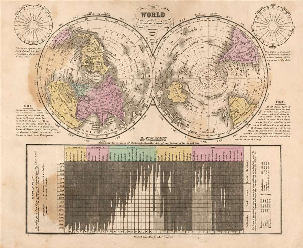
This is a fascinating 1841 Jesse Olney polar projection world map reflecting the educational, geographical, and religious values of mid-19th century America.
A Closer Look
The northern and southern hemispheres are presented to the left and right; these are annotated with data reflecting world knowledge in the first half of the 19th century. For example, Antarctica is not indicated, but the South Shetland Islands, discovered in 1819, do appear. The presentation of the Arctic seas suggest the possibility of a Northeast Passage. Two subordinate circular tables in the upper left and right show the longitudes of important locations around the globe, and the time difference between those locations, respectively. The bottom of the map is dominated by a chronological chart illustrating the prevalence of Christianity worldwide, as opposed to Islam and Paganism. The wash color of the table heading corresponds to the coloring on the corresponding regions of the map.Olney the Educator
Designed for inclusion in Olney's school geographical atlas, this map conforms to that author's intent to teach geographical ideas rooted in matter which closely related to that of his student audience. His model was to start with areas that were concrete and local for the learner, and to gradually address broader and more abstract concepts. This is the reason for the use of a polar projection here: by presenting the globe's lines of longitude as seen from the poles, the mapmaker was able to clearly note the time on the globe relative to noon at Greenwich; for the typical school student, a practical understanding of the reckoning of time and the impact of the sphericality of the globe on that reckoning would be an essential takeaway. Geography was traditionally taught in the opposite fashion: beginning with astronomy and the solar system, and working down regional specifics.The Progress of Christianity
Olney was an active Unitarian and embraced the religious ferment of 19th century America. Such an explicitly religious statement in a school textbook as is represented in the table - expressing the 'progress' of Christianity worldwide in opposition to paganism and Islam - reflected the widespread belief that once the world was fully Christianized - the Second Coming would follow.Publication History and Census
This map was executed for inclusion in the 1841 edition of Olney's New and Improved School Atlas. The book is well represented in institutional collections, but this state of the separate map does not appear in OCLC. Earlier examples of the map with the same title in some cases lack the subordinate time/longitude diagrams, and some also lack the religious table at bottom.Cartographer
Jesse Olney (1798 - 1872) was an American geographer, primarily active and successful in the production of school textbooks on that subject. His sales were second only to thos of Webster's American Spelling Book. He was educated in Whitesboro, New York, and would work as a teacher both there and in Binghamton. From 1819 to 1831 he served as principal of the Stone School in Hartford, Connecticut. In 1828 he published A Geography and Atlas, which for thirty years would be the standard geographical text used throughout the United States. It was many times enlarged and revised, and ran through 98 editions. While prior geographies opened with a description of astronomy and the solar system - a convention harkening back to Ptolemy, and the discipline of cosmography - Olney chose instead to center his pedagogy on the student's home town, expanding instead from there. The intention was to guide the student in study of the Earth by moving from that which was near and familiar to what was distant and abstract. He would later expand his repertoire of textbooks to include readers, arithmetic books, and United States history. He would enter the Connecticut legislature, using his position to influence the development of that state's schools. A Unitarian, he would be also active in advocacy for the liberal religious movements in New England. More by this mapmaker...
Source
Olney, J., Olney's School Atlas, (Hartford: Pratt) 1841.
Condition
Good. Some stains and marginal mends, else very good with original wash color.
References
This state not in OCLC.