This item has been sold, but you can get on the Waitlist to be notified if another example becomes available, or purchase a digital scan.
1798 Payne Map of the World (pre 1800 American Map)
World-payne-1798$112.50

Title
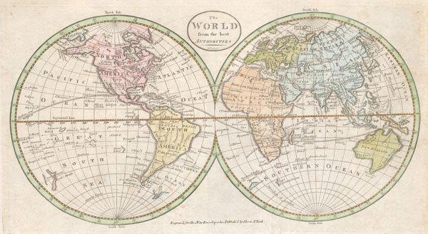
The World from the best authorities.
1798 (undated) 8 x 15 in (20.32 x 38.1 cm)
1798 (undated) 8 x 15 in (20.32 x 38.1 cm)
Description
An extremely rare and unusual map of the world. Printed in 1798, this is one of the first maps of the world published for general audiences in the New World. While lacking in the refinement commonly seen in European maps of the same period, this map is worthy of special note by collectors as a fine example of early American cartography. Map depicts the entire world on a hemisphere projection. Geographically offers a few curious anomalies and curiosities. Alaska is expressed in its general form if bloated and inflated in the Aleutian region. Depicts several oddities in the South Pacific including 'Davis's Land and 'Land Seen by Quiros.' 'Davis's Land' appeared on a few charts in the later part of the 19th century and was supposedly discovered by Captain Davis 1722. It was claimed that 'Davis's Land' was a large body of land south and slightly to the east of the Galapagos Islands. Some suppose it to have been Easter Island, while others simply suggest that it was a complete fabrication. Antarctica is shown sketchily as Terra Australis, Cape Circumcision, and the Gulf of Sebastian. In Australia, or New Holland as it is labeled, Tasmania (Van Diemen's Land) is attached to the Australian mainland. In east Asia, map depicts the Sea of Korea, Yeso Island, and mysterious Company's Land. Prepared by Rollinson for John Payne's New Universal Geography and I. Low's New Encyclopedia.
Cartographer
John Payne (fl. c. 1780 - c. 1800) was a little known cartographer and map publisher working in New York and Philadelphia in the last years of the 18th century. Nothing is known of his youth and education. He is known to have published Joseph Collyer's 1772 New System of Geography in London, and his own work is probably descended from Collyer's. Payne published, again in London, his two-volume Universal geography formed into a new and entire system in 1791. Dublin editions under this title appeared in 1792 and 1794, lacking maps and reducing the general geography to a glossary to make room travellers' tales, notably those of Hawkesworth: it is probably that Payne had nothing to do with the Dublin editions, which were almost certainly pirate editions. Sometime during the 1790s Payne emigrated to New York, where he would publish in 1798-9 Payne's New and Complete Universal Geography, one of the first examples of American - printed commercial cartography. More by this mapmaker...
Condition
Very good condition. Original folds. Minor age toning. Else clean. Blank on verso.
References
Wheat, James Clements and Brun, Maps and Charts Published in America before 1800; a Bibliography, #40. Phillips (Atlases) 4303-1. Smith, ”Realms of Gold”: A Catalogue of Maps in the Library of the American Philosophical Society, #78b. East Asian Library, Map Collection, EAMC 096. Kerry, Robert, A General History and Collection of Voyages and Travels, page 267-9.