This item has been sold, but you can get on the Waitlist to be notified if another example becomes available, or purchase a digital scan.
1696 Zahn Map of the World in Two Hemispheres
World-zahn-1696$3,000.00

Title
Facies una Hemi-sphaerii Terrestris. Facies Altern Hemi-sphaerii Terrestris.
1696 (undated) 14.5 x 34 in (36.83 x 86.36 cm)
1696 (undated) 14.5 x 34 in (36.83 x 86.36 cm)
Description
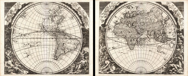
An extremely rare discovery, this is a wonderful 1693 double hemisphere map of the world in two panels. Both of these maps were drawn and engraved by the German Enlightenment era polymath Johann Zahn for his pseudo-scientific opus Mundus Mirabili, or the 'Marvelous World.' This, Zahn's cartographic masterpiece, is a smorgasbord of carto-curiosity featuring such unusual elements as an insular California, the Great Lakes rendered as a single body of water open to the west, the strait of Anian far to the north, El Dorado or Manoa on the shores of the mythical Lake Parima, the legendary Lago de los Xarayes, an erroneously oriented Caspian Sea, a speculative Ptolemaic mapping of the sources of the Nile, an incomplete Australia, and the five great rivers of southeast Asia radiating from a single apocryphal lake , among others.
Our survey of this map will begin with North America on the western hemisphere sheet. North America is rendered according to the common 17th century Dutch conception and owes much to the work of Nicholas Visscher whose maps played a significant role in promoting the 'California as an Island' hypothesis. The concept of an insular California first appeared as a work of fiction in Garci Rodriguez de Montalvo's c. 1510 romance Las Sergas de Esplandian, where he writes
Zahn's rendering of the Great Lakes as a single body of water open to the west is of particular interest and is the most ephemeral element of this map, being updated in most subsequent maps to reflect ongoing European exploration of the region. At first glance Zahn's great inland sea appears uncannily like Verazanno's Sea, a 16th century speculative body of water extending to the Pacific through the center of North America, which was no doubt a direct influence on the water form established here. Subsequent mapping of this region would see this great inland sea replaced by more contemporary rendering of the Great Lakes taken from the explorations of La Salle, Hennepin, and others.
North of insular California we find the land of Anian, separated from the North American mainland by a narrow strait. Anian is generally considered to be an undiscovered land or strait in the extreme northwestern part of America. The earliest known reference to Anian is in the narratives of Marco Polo, who describes it as 'East of India.' In many early maps Anian appears as an imaginary proto-Bearing Strait, the Strait of Anian, separating Asia from America. Zahn's treatment of Anian is unusual. Here Anian appears both as a land and as a Strait, with the landmass of Anian situated to the west of the Strait of Anian and moreover undefined in its western extension, thus suggesting the possibility that Anian is in fact attached not to America, but to the another land, possibly Compagnie?
Compagnie itself appears in the extreme northwest quadrant of this map, separated from Anian, flat-topped California, and North America in general by a vast sea. However, like the land of Anian, part of Compagnie, its eastern shores, are left open and unmapped. Is Zahn suggesting that Anian and Compagnie may be connected or even one and the same? Compagnie was supposedly discovered in 1643 by Dutch East India Company (V.O.C.) ships, under De Vries, exploring the northern Japan and the Kuril Islands. De Vries named one islands Staten Island, as noted here. Today this island is commonly associated with Iturup in the Kurils, but here it acts as a gate way to Compagnie Land. Theoretically Compagnie may well be an embryonic mapping of Kamtschatka, however, in other contemporary maps, such as those of Sanson, Compagnie takes on near continental proportions stretching most of the way to North America. It is not inconceivable that many early cartographers assumed that this was the legendary Anian.
In many period maps and literature, Anian is intimately associated with the Northwest Passage. John Donn wrote, 'Anyan if I go west by the North-West passage.' Zahn's treatment of the Northwest Passage is most curious, for he intentionally and fully closes the Hudson Bay while leaving the Strait of Anian open at the eastern end, suggesting, possibly, that the only hope of discovering the legendary passage must come from the west.
In the western part of America there appears a primitive speculative rendering of what might be interpreted as the Great Salt Lake. Though cartographically impossible given that the Great Salt Lake or the Great Basin would not be even tentatively explored until nearly 150 years later by Miera and Escalante, Zahn's rendering seems surprisingly accurate. Most likely this is little more than happenstance relating to speculation on possible sources for the Colorado River, here labeled Rio del Norto.
Further south the cartography of South America is nearly as confused as that of North America. Though by this point in history, the general outlines of South America are well established by regular circumnavigations of the continent, the interior is entirely speculative. Even the great Amazon River is poorly and inaccurately rendered both regarding its general orientation and its connection with other large South American river systems, most notably the Paraguay. Zahn also recognizes two popular misconceptions regarding the mythical kingdoms of the Amazon, El Dorado and Xarayes.
In Zahn's time many Europeans believed that the most likely site of El Dorado was the mythical city of Manoa located on the shores of the Lake Parima, near modern day Guyana, Venezuela, or northern Brazil. Manoa was first identified by Sr. Walter Raleigh in 1595. Raleigh does not visit the city of Manoa (which he believes is El Dorado) himself due to the onset of the rainy season, however he describes the city, based on indigenous accounts, as resting on a salt lake over 200 leagues wide. This lake, though no longer mapped as such, does have some basis in fact. Parts of the Amazon were at the time dominated by a large and powerful indigenous trading nation known as the Manoa. The Manoa traded the length and breadth of the Amazon. The onset of the rainy season inundated the great savannahs of the Rupununi, Takutu, and Rio Branco or Parima Rivers. This inundation briefly connected the Amazon and Orinoco river systems, opening an annual and well used trade route for the Manoans. The Manoans who traded with the Incans in the western Amazon, had access to gold mines on the western slopes of the Andes, and so, when Raleigh saw gold rich Indian traders arriving in Guyana, he made the natural assumption for a rapacious European in search of El Dorado. When he asked the Orinocans where the traders were from, they could only answer, 'Manoa.' Thus did Lake Parime or Parima and the city of Manoa begin to appear on maps in the early 17th century. The city of Manoa and Lake Parima would continue to be mapped in this area until about 1800.
In the center of South America, Zahn maps a large and prominent Laguna de Xarayes as the northern terminus of the Paraguay River. The Xarayes, a corruption of 'Xaraiés' meaning 'Masters of the River', were an indigenous people occupying what are today parts of Brazil's Matte Grosso and the Pantanal. When Spanish and Portuguese explorers first navigated the Paraguay River, as always in search of El Dorado, they encountered the vast Pantanal flood plain at the height of its annual inundation. Understandably misinterpreting the flood plain as a gigantic inland sea, they named it after the local inhabitants, the Xaraies. The Laguna de los Xarayes, accessible only through the Gate of Kings, almost immediately began to appear on early maps of the region and, at the same time, took on a legendary aspect. The Lac or Laguna Xarayes was often considered to be a gateway to the Amazon and the Kingdom of El Dorado. Here Zahn's rendering suggest exactly that, with a wide navigable Rio De La Plata leading directly to the Paraguay River and connecting clearly to the Lago de los Xarayes and thus the Amazon itself.
To the west, in the south Pacific, several island chains are noted though few are easily associable with modern Polynesian islands. Most of these no doubt reference discoveries Frances Drake, Abel Tasman, Pedro Fernandez de Quiros, and others though here Dutch names are given so specific associations are difficult. New Zealand (Zelandia Nova), however, is clearly noted according to the explorations of Abel Tasmen and Maria van Diemen, though the eastern shores are unexplored.
Crossing the Atlantic we move to the Eastern Hemisphere sheet and find ourselves on the great continent of Africa. Like South America, Africa is well mapped along its shores but speculative in the interior. With regard to the course of the Nile, Zahn followed the Ptolemaic two-lake-at-the-base-of-the-Montes-de-Lune theory. Though Zahn does map both lakes he does not render the Mountains of the Moon as this map does not include topography. We must, nonetheless, suppose they are present in spirit.
Moving into Asia, Zahn offers us a fairly accurate mapping of Asia Minor, Persia and India. The Capsian Sea is erroneously mapped on an east-west axis and is a bit lumpy in form. He names numerous Silk Route cities through Central Asia including Samarkand, Corasan, Kasakki, and Targana. Far to the north in Mongolia and Siberia the Biblical lands of Gog and Magog, common on maps of this period, are replaced by factual and semi-factual tribes and cities, including Xandu, Tengvth, and Tartar, most of which are no doubt derived from Marco Polo's narratives.
Zahn maps, but does not name, the apocryphal Lake of Chiamay roughly in what is today Assam, India. Early cartographers speculated that such a lake must exist as the source of four important Southeast Asian river systems including the Irrawaddy, the Dharla, the Chao Phraya, and the Brahmaputra. This lake began to appear in maps of this region as early as the 16th century and persisted well into the mid-18th century. Its origins are unknown but may originate in a lost 16th century geography prepared by the Portuguese scholar Jao de Barros. It was also heavily discussed in the journals of Sven Hedin, who believed it to be associated with Indian spiritual geographicus that suggest a sacred lake linked several holy subcontinent river systems. There are even records that the King of Siam led an invasionary force to take control of the lake in the 16th century. Nonetheless, the theory of Lake Chimmay was ultimately disproved and it disappeared from maps entirely by the 1760s.
Australia, here labeled Hollandia Nova, is only tenuously mapped with the southern, eastern, and part of the western coast undefined. Most of the cartographic knowledge of Australis is, at this point, based on the explorations of Abel Tasmen and Maria van Diemen. The remainder of Australia, despite several expeditions, would not be fully mapped until the late 18th century.
Though this map offers much, it is also notable for what it does not include. Zahn makes a bold and prescient statement in choosing not to map the speculative southern continent of Terre Australe. Long before the discovery of Antarctica, the southern continent, supposedly capping the South Pole, was speculated upon by European geographers of the 16th and 17th centuries. It was thought, according to Platonic theory, that the globe was a place of balances and thus geographers presumed the bulk of Eurasia must be counterbalanced by a similar landmass in the Southern Hemisphere, just as, they argued, the Americas counterbalanced Africa and Europe. Many explorers in the 16th and 17th centuries sought the Great Southern continent, including Quiros, Drake, and Cook, but Antarctica itself was not truly discovered until Edward Bransfield and William Smith sighted the Antarctic Peninsula in 1820. In choosing not to include Terre Australe, Zahn is breaking with a long standing cartographic convention common both before and after this publication of his map.
Of particular note is the stunning border art surrounding both maps. Zahn was a phenomenal engraver and the artistry of his border is far above standard cartouche work. His figures, including women, putti, and children, are wonderfully expressive and elegantly rendered in emotive active poses. Along the top of both sheets are portions of the Zodiac, with all twelve signs represented. This is an exceptionally beautiful example of this particular man, uncolored as issued and a very strong impression overall. In fact the intensity of the impressions suggests that this example must have been one of the first maps run off the printing plates – which tend to yield fainter impressions after a number of printings.
Engraved by Johann Zahn and published as plate 6 in volume II of Zahn's 1693 Mundus Mirabili.
Our survey of this map will begin with North America on the western hemisphere sheet. North America is rendered according to the common 17th century Dutch conception and owes much to the work of Nicholas Visscher whose maps played a significant role in promoting the 'California as an Island' hypothesis. The concept of an insular California first appeared as a work of fiction in Garci Rodriguez de Montalvo's c. 1510 romance Las Sergas de Esplandian, where he writes
Know, that on the right hand of the Indies there is an island called California very close to the side of the Terrestrial Paradise; and it is peopled by black women, without any man among them, for they live in the manner of Amazons.Baja California was subsequently discovered in 1533 by Fortun Ximenez, who had been sent to the area by Hernan Cortez. When Cortez himself traveled to Baja, he must have had Montalvo's novel in mind, for he immediately claimed the 'Island of California' for the Spanish King. By the late 16th and early 17th century ample evidence had been amassed, through explorations of the region by Francisco de Ulloa, Hernando de Alarcon, and others, that California was in fact a peninsula. However, by this time other factors were in play. Francis Drake had sailed north and claimed 'New Albion' near modern day Washington or Vancouver for England. The Spanish thus needed to promote Cortez's claim on the 'Island of California' to preempt English claims on the western coast of North America. The significant influence of the Spanish crown on European cartographers caused a major resurgence of the Insular California theory. About half a century after this map was drawn Eusebio Kino, a Jesuit missionary, published his own 1705 account of travels overland from Mexico to California, establishing conclusively the peninsularity of California.
Zahn's rendering of the Great Lakes as a single body of water open to the west is of particular interest and is the most ephemeral element of this map, being updated in most subsequent maps to reflect ongoing European exploration of the region. At first glance Zahn's great inland sea appears uncannily like Verazanno's Sea, a 16th century speculative body of water extending to the Pacific through the center of North America, which was no doubt a direct influence on the water form established here. Subsequent mapping of this region would see this great inland sea replaced by more contemporary rendering of the Great Lakes taken from the explorations of La Salle, Hennepin, and others.
North of insular California we find the land of Anian, separated from the North American mainland by a narrow strait. Anian is generally considered to be an undiscovered land or strait in the extreme northwestern part of America. The earliest known reference to Anian is in the narratives of Marco Polo, who describes it as 'East of India.' In many early maps Anian appears as an imaginary proto-Bearing Strait, the Strait of Anian, separating Asia from America. Zahn's treatment of Anian is unusual. Here Anian appears both as a land and as a Strait, with the landmass of Anian situated to the west of the Strait of Anian and moreover undefined in its western extension, thus suggesting the possibility that Anian is in fact attached not to America, but to the another land, possibly Compagnie?
Compagnie itself appears in the extreme northwest quadrant of this map, separated from Anian, flat-topped California, and North America in general by a vast sea. However, like the land of Anian, part of Compagnie, its eastern shores, are left open and unmapped. Is Zahn suggesting that Anian and Compagnie may be connected or even one and the same? Compagnie was supposedly discovered in 1643 by Dutch East India Company (V.O.C.) ships, under De Vries, exploring the northern Japan and the Kuril Islands. De Vries named one islands Staten Island, as noted here. Today this island is commonly associated with Iturup in the Kurils, but here it acts as a gate way to Compagnie Land. Theoretically Compagnie may well be an embryonic mapping of Kamtschatka, however, in other contemporary maps, such as those of Sanson, Compagnie takes on near continental proportions stretching most of the way to North America. It is not inconceivable that many early cartographers assumed that this was the legendary Anian.
In many period maps and literature, Anian is intimately associated with the Northwest Passage. John Donn wrote, 'Anyan if I go west by the North-West passage.' Zahn's treatment of the Northwest Passage is most curious, for he intentionally and fully closes the Hudson Bay while leaving the Strait of Anian open at the eastern end, suggesting, possibly, that the only hope of discovering the legendary passage must come from the west.
In the western part of America there appears a primitive speculative rendering of what might be interpreted as the Great Salt Lake. Though cartographically impossible given that the Great Salt Lake or the Great Basin would not be even tentatively explored until nearly 150 years later by Miera and Escalante, Zahn's rendering seems surprisingly accurate. Most likely this is little more than happenstance relating to speculation on possible sources for the Colorado River, here labeled Rio del Norto.
Further south the cartography of South America is nearly as confused as that of North America. Though by this point in history, the general outlines of South America are well established by regular circumnavigations of the continent, the interior is entirely speculative. Even the great Amazon River is poorly and inaccurately rendered both regarding its general orientation and its connection with other large South American river systems, most notably the Paraguay. Zahn also recognizes two popular misconceptions regarding the mythical kingdoms of the Amazon, El Dorado and Xarayes.
In Zahn's time many Europeans believed that the most likely site of El Dorado was the mythical city of Manoa located on the shores of the Lake Parima, near modern day Guyana, Venezuela, or northern Brazil. Manoa was first identified by Sr. Walter Raleigh in 1595. Raleigh does not visit the city of Manoa (which he believes is El Dorado) himself due to the onset of the rainy season, however he describes the city, based on indigenous accounts, as resting on a salt lake over 200 leagues wide. This lake, though no longer mapped as such, does have some basis in fact. Parts of the Amazon were at the time dominated by a large and powerful indigenous trading nation known as the Manoa. The Manoa traded the length and breadth of the Amazon. The onset of the rainy season inundated the great savannahs of the Rupununi, Takutu, and Rio Branco or Parima Rivers. This inundation briefly connected the Amazon and Orinoco river systems, opening an annual and well used trade route for the Manoans. The Manoans who traded with the Incans in the western Amazon, had access to gold mines on the western slopes of the Andes, and so, when Raleigh saw gold rich Indian traders arriving in Guyana, he made the natural assumption for a rapacious European in search of El Dorado. When he asked the Orinocans where the traders were from, they could only answer, 'Manoa.' Thus did Lake Parime or Parima and the city of Manoa begin to appear on maps in the early 17th century. The city of Manoa and Lake Parima would continue to be mapped in this area until about 1800.
In the center of South America, Zahn maps a large and prominent Laguna de Xarayes as the northern terminus of the Paraguay River. The Xarayes, a corruption of 'Xaraiés' meaning 'Masters of the River', were an indigenous people occupying what are today parts of Brazil's Matte Grosso and the Pantanal. When Spanish and Portuguese explorers first navigated the Paraguay River, as always in search of El Dorado, they encountered the vast Pantanal flood plain at the height of its annual inundation. Understandably misinterpreting the flood plain as a gigantic inland sea, they named it after the local inhabitants, the Xaraies. The Laguna de los Xarayes, accessible only through the Gate of Kings, almost immediately began to appear on early maps of the region and, at the same time, took on a legendary aspect. The Lac or Laguna Xarayes was often considered to be a gateway to the Amazon and the Kingdom of El Dorado. Here Zahn's rendering suggest exactly that, with a wide navigable Rio De La Plata leading directly to the Paraguay River and connecting clearly to the Lago de los Xarayes and thus the Amazon itself.
To the west, in the south Pacific, several island chains are noted though few are easily associable with modern Polynesian islands. Most of these no doubt reference discoveries Frances Drake, Abel Tasman, Pedro Fernandez de Quiros, and others though here Dutch names are given so specific associations are difficult. New Zealand (Zelandia Nova), however, is clearly noted according to the explorations of Abel Tasmen and Maria van Diemen, though the eastern shores are unexplored.
Crossing the Atlantic we move to the Eastern Hemisphere sheet and find ourselves on the great continent of Africa. Like South America, Africa is well mapped along its shores but speculative in the interior. With regard to the course of the Nile, Zahn followed the Ptolemaic two-lake-at-the-base-of-the-Montes-de-Lune theory. Though Zahn does map both lakes he does not render the Mountains of the Moon as this map does not include topography. We must, nonetheless, suppose they are present in spirit.
Moving into Asia, Zahn offers us a fairly accurate mapping of Asia Minor, Persia and India. The Capsian Sea is erroneously mapped on an east-west axis and is a bit lumpy in form. He names numerous Silk Route cities through Central Asia including Samarkand, Corasan, Kasakki, and Targana. Far to the north in Mongolia and Siberia the Biblical lands of Gog and Magog, common on maps of this period, are replaced by factual and semi-factual tribes and cities, including Xandu, Tengvth, and Tartar, most of which are no doubt derived from Marco Polo's narratives.
Zahn maps, but does not name, the apocryphal Lake of Chiamay roughly in what is today Assam, India. Early cartographers speculated that such a lake must exist as the source of four important Southeast Asian river systems including the Irrawaddy, the Dharla, the Chao Phraya, and the Brahmaputra. This lake began to appear in maps of this region as early as the 16th century and persisted well into the mid-18th century. Its origins are unknown but may originate in a lost 16th century geography prepared by the Portuguese scholar Jao de Barros. It was also heavily discussed in the journals of Sven Hedin, who believed it to be associated with Indian spiritual geographicus that suggest a sacred lake linked several holy subcontinent river systems. There are even records that the King of Siam led an invasionary force to take control of the lake in the 16th century. Nonetheless, the theory of Lake Chimmay was ultimately disproved and it disappeared from maps entirely by the 1760s.
Australia, here labeled Hollandia Nova, is only tenuously mapped with the southern, eastern, and part of the western coast undefined. Most of the cartographic knowledge of Australis is, at this point, based on the explorations of Abel Tasmen and Maria van Diemen. The remainder of Australia, despite several expeditions, would not be fully mapped until the late 18th century.
Though this map offers much, it is also notable for what it does not include. Zahn makes a bold and prescient statement in choosing not to map the speculative southern continent of Terre Australe. Long before the discovery of Antarctica, the southern continent, supposedly capping the South Pole, was speculated upon by European geographers of the 16th and 17th centuries. It was thought, according to Platonic theory, that the globe was a place of balances and thus geographers presumed the bulk of Eurasia must be counterbalanced by a similar landmass in the Southern Hemisphere, just as, they argued, the Americas counterbalanced Africa and Europe. Many explorers in the 16th and 17th centuries sought the Great Southern continent, including Quiros, Drake, and Cook, but Antarctica itself was not truly discovered until Edward Bransfield and William Smith sighted the Antarctic Peninsula in 1820. In choosing not to include Terre Australe, Zahn is breaking with a long standing cartographic convention common both before and after this publication of his map.
Of particular note is the stunning border art surrounding both maps. Zahn was a phenomenal engraver and the artistry of his border is far above standard cartouche work. His figures, including women, putti, and children, are wonderfully expressive and elegantly rendered in emotive active poses. Along the top of both sheets are portions of the Zodiac, with all twelve signs represented. This is an exceptionally beautiful example of this particular man, uncolored as issued and a very strong impression overall. In fact the intensity of the impressions suggests that this example must have been one of the first maps run off the printing plates – which tend to yield fainter impressions after a number of printings.
Engraved by Johann Zahn and published as plate 6 in volume II of Zahn's 1693 Mundus Mirabili.
Cartographer
Johann Zahn (1641-1707) was a German philosopher, cartographer, scientist and mathematician active in the second half of the 17th century. Zahn was a canon of the Premonstrate Order in Würzburg under Cardinal Brandr Beekman-Ellner. Truly an Enlightenment scholar, Zahn is best known for his contributions to the early development of photography associated with his most celebrated work, Oculus Artificialis, a detailed discussion of the Camera Obscura. Zahn was also a prolific writer, illustrator, and engraver whose pseudo-scientific works include the Mundus Mirabili, or the "Marvelous World", which features a number of beautifully engraved maps. More by this mapmaker...
Source
Zahn, J., Mundus Mirabili, vol II, (Nuremburg) 1696.
Condition
Very good near pristine condition. Crisp dark impression. Blank on verso.
References
McLaughlin, G., The Mapping of California as an Island: An Illustrated Checklist, 122. Shirley, R, The Mapping of the World: Early Printed World Maps 1472 - 1700, 584 (plate 403).