This item has been sold, but you can get on the Waitlist to be notified if another example becomes available, or purchase a digital scan.
1851 Black Map of Ancient World and the Empire of Alexander
WorldAlexander-black-1851$62.50

Title
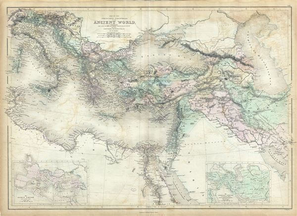
Map of the Principal Countries of the Ancient World extending from The Alps to the Southern Frontier of Egypt and from Carthage to Persepolis.
1851 (undated) 17 x 24 in (43.18 x 60.96 cm)
1851 (undated) 17 x 24 in (43.18 x 60.96 cm)
Description
This is a fine example of Adam and Charles Black's 1851 map of the principal counties of the Ancient World. The map depicts part of the empire of Alexander the Great and covers from modern day Italy south as far as egypt and from Corsica to Caspian Sea. An inset map in the lower left quadrant depicts the Roman empire in its greatest extent and another map in the lower right quadrant features the Persian empire in its greatest extent, divided into its Satrapies. Hughes engraved this map to illustrate the conquests of the Macedonian King Alexander III, called ‘the Great,' conqueror of the Persian empire and at just thirty, ruler of one of the largest empires in history. Alexander the Great was undefeated in battle and is considered one of the most successful military commanders of all time. Various towns, cities, mountains, rivers, oases and several other topographical details are noted with relief shown by hachure. This map was engraved by William Hughes and issued as plate no. LIX in the 1851 edition of Black's General Atlas of the World.
CartographerS
Charles and Adam Black (fl. 1807 - present) were map and book publishers based in Edinburgh. Charles and his uncle, Adam, both of Edinburgh, Scotland, founded their publishing firm in 1807. They published a series of maps and atlases throughout the 19th century. In addition to an array of atlases, the Black firm is known for their editions of the Encyclopedia Britannica (1817 - 1826) and the first publishing of Sir Walter Scott's novels in 1854. In 1889 the A. & C. Black publishing house moved to London where it remains in operation to this day. More by this mapmaker...
William Hughes (c. 1818 - May 21, 1876) was a cartographer, engraver, lithographer, printer, and publisher active in London during the middle part of the 19th century. Hughes enjoyed and long and varied cartographic career. He was elected a Fellow of the Royal Geographical Society in 1838 and, from about 1840, taught geography and mapmaking at St. Johns College for Civil Engineers. He later taught the same at both Queens College and Kings College, London. For a time he was employed as a map librarian for the British Museum. Hughes began engraving maps around 1839 and worked with most of the prominent British map and atlas publishers of his era, including but not limited to Charles Knight, A. and C. Black, George Philip, William Cassell, and others. Learn More...
Source
Black, A. and C., General Atlas Of The World, (Edinburgh) 1851.
Condition
Good. Minor overall toning. Blank on verso. Offestting. Verso repair on original centerfold.
References
Rumsey 2305.071 (1854 edition). Philips (atlases) 4334.