This item has been sold, but you can get on the Waitlist to be notified if another example becomes available, or purchase a digital scan.
1872 Hewitt Map of the World showing Coffee Produciton (inscribed)
WorldCoffee-hewitt-1872$500.00

Title
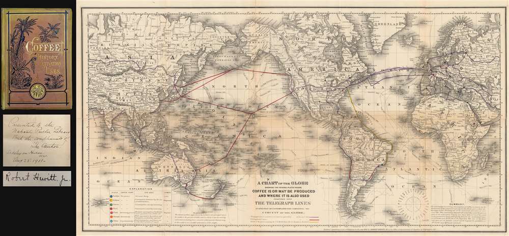
A Chart of the Globe Showing the Several Places Where Coffee is or May be Produced and Where it is also used together with The Telegraph Lines in operation or contemplated for completing the Circuit of the Globe.
1872 (dated) 14.5 x 26 in (36.83 x 66.04 cm) 1 : 450000000
1872 (dated) 14.5 x 26 in (36.83 x 66.04 cm) 1 : 450000000
Description
A fascinating 1872 thematic map of the world by Robert Hewitt detailing the global production and traffic in coffee - considered the first American map related to Coffee - accompanied by a signed first edition of Hewitt's important book on coffee. Presented on Mercator's projection, the map dually identifies coffee production and consumption, and telegraph lines. A series of color codes referenced in the lower right breaks down the region according to the ability to grow and use coffee, and its rate of consumption, with places like Rio de Janeiro, Colombo (Sri Lanka), and Sumatra as centers of both production and consumption, places of increasing consumption, like Melbourne (Australia), the United States, places of limited consumption (mostly Scandinavian countries), and everything in between.
Hewitt's Summary
In the lower right corner, Hewitt summarizes his map in the context of the coffee trade,The constantly increasing consumption of Coffee as shown by the Statistical Tables prepared expressly for this Work, proves that the beverage is fast becoming one of the universal necessities of civilized life. This increasing demand will naturally extend the present area of its cultivation largely into those belts of land favorable to its production lying principally between the isothermal lines of 25° North and 30° South of the Equator. The use of the beverage does not at present extend much beyond the parallels of 58° North and 35° South.The 'land favorable' is here highlighted as a shaded area at center, loosly bounded by the Tropics of Cancer and Capricorn, illustrate the climatic zone where coffee can be viably grown.
Telegraph and Steamer Lines
The map also includes the extent U.S. Mail packet steamer route from Rio de Janeiro to New York, as well as existing and proposed telegraph lines, underscoring the importance of communication and transportation to global growth of coffee consumption. Hewitt attributes the submarine telegraph cables to increased interest in remote coffee regions,Of late years there has been a growing desire to know more about the coffee-producing districts in Java and Sumatra. The opening of the Pacific Railroad and the successful operation of the Submarine cables have done much to bring about more frequent communication with these important countries. American merchants have not been slow in availing themselves of the advantages in becoming better acquainted with those who have established important house in the East Indies … for much valuable information concerning the cultivation of coffee.The Rio-New York mail packet route is of particular note, as it is associated with coffee plantations in Brazil. These Hewitt discusses at length in his work, detailing the volume and procedure of shipping bulk coffee from ports of Rio de Janeiro and Santos to New York.
Inscription and Provenance
As noted, this map accompanies Hewitt's work Coffee: Its History, Cultivation, and Uses, here it its first edition in a fine state. The work was inscribed by Hewitt and presented to the Nahant Public Library in 1911. The present map and book were deaccessioned from that institution but still bear its bookplate and stamp.Publication History and Census
Hewitt prepared this map in 1872 to illustrate his most famous work, Coffee: Its History, Cultivation, and Uses. The map itself is derived from the J. H. Colton world map of 1857, but no credit is here given. The shading and coffee related content, as well as the proposed and extant telegraph data, is unique to this map. The individual map is scarce on the market and has no reference in the OCLC, but Hewitt's book does appear in several collections.Source
Hewitt, R., Coffee: Its History, Cultivation, and Uses, (New York: D. Appleton and Company) 1872.
Condition
Good. Some older library-style restoraiton and reinforcemnt to some of the fold lines. Accompanies Hewitt's book. Book in very good condition. Tight binding. Inscribed by author. Some library stamps and bookplate.