This item has been sold, but you can get on the Waitlist to be notified if another example becomes available, or purchase a digital scan.
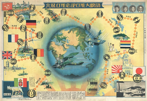
1925 Taisho 14 Japanese Pictorial Map of the World and Sugoroku Gameboard
WorldFlightGame-asahishimbun-1925
Title
1925 (dated) 21 x 31 in (53.34 x 78.74 cm)
Description
In the summer of 1925, the Asahi Shinbun (朝日新聞) sponsored the transcontinental flight by providing two Breguet 19 G.R. biplanes named, Hatsukaze (First Wind) and Kochikaze (East Wind). The biplanes were piloted by Japanese army flight officers, and accompanying engineers. Yusun Abe Hiroshi (pilot) and Shinohara Shunichiro (engineer) piloted the Hatsukaze, while Kawachi Kazuhiko (pilot) and Katagiri Shohei (engineer) piloted the Kochikaze. These aviator heros are pictured in the upper right, Shinohara, Katagiri, Kawachi, and Yasun Abe (from right). They took off from Tokyo on July, 25 1925. They flew via Siberia to Moscow, then on to Berlin, Paris, London, and other cities, finally landing in Rome, their ultimate destination, on October 27, 1925. The distance they covered was 16,565 km with a total flight time of 110 hours and 50 minutes.
Historically there are two variants of sugoroku, one that is similar to backgammon, and the presently offered 'snakes and ladders' variant. This version of the game appeared as early as the 13th century, and was popularized by the rise of printing technology, especially in the Edo and Meiji periods, and subsequent availability of high-quality visually-arresting game boards. A standard sugoroku board has a starting point, the furi-dashi, and a winding or spiral path terminating at the agari or finish-line. In this case the furi-dashi is Tokyo, Japan, pictured in the lower right and the agari is Rome, Italy, pictured in the lower left. Along the way players retrace the historic flight, stopping in the same places the actual aviators visited.
One element of interest is the appearance of the term Chosŏn Haehyŏp (朝鮮海峡)to describe the strait between Japan and Korea. The Japanese name of this strait is Tsushima Kaikyō (対馬海峡). Japan and Korea have a long history of arguing over the naming of this body of water and the Sea of Japan / Korea to the north. It is exceptionally odd to see the Korean term used here in a Japanese publication intended to promote Japanese national pride.
This map game was issued by the Asahi Shimbun (朝日新聞) as a supplement to the December 10, 1925 issue.
Cartographer
The Asahi Shimbun (朝日新聞; January 25, 1879 – Present), translated Morning Sun Newspaper, is one of Japan's oldest and most venerable daily newspapers. The Asahi Shimbun began publication in Osaka on January 25, 1879 as a small-print, four-page illustrated paper. The paper was founded by Kimura Noboru (company president), Murayama Ryōhei (owner), and Tsuda Tei (managing editor). In 1888 the newspaper expanded with a branch in Tokyo and began issuing the Tokyo Asahi Shimbun. The the Osaka and Tokyo papers formally merged under a single imprint in 1940. Almost from its inception the newspaper was known for its liberal views. The Asahi Shimbun continues to publish from Osaka today. More by this mapmaker...

