This item has been sold, but you can get on the Waitlist to be notified if another example becomes available, or purchase a digital scan.
1880 Kellner Wall Map of the World in Hemispheres
WorldHemipsheres-kellner-1880$1,100.00

Title
Westliche Halbkugel. / Ostliche Halbkugel.
1880 (undated) 52 x 84 in (132.08 x 213.36 cm) 1 : 24625000
1880 (undated) 52 x 84 in (132.08 x 213.36 cm) 1 : 24625000
Description
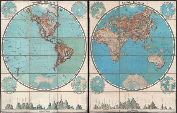
A remarkable c. 1880 set of German color photo-lithograph wall maps of the world in two hemispheres. Each monumental hemisphere sheet measures 52 x 42 inches, for a total wall display size of 84 x 52 inches. The left hand sheet details the Western Hemisphere with a focus on topography, river systems, and terrain. The right hand sheet similarly illustrates the Eastern Hemisphere (Africa, Europe, Asia, and Australia). Antarctica appears at the bottom of both maps. Political entities are not identified, but important cities, lakes, rivers, and other bodies of water are. At the base of the maps there are mountain profile charts illustrating the relative heights of the world's great mountains. Surrounding each map are four smaller maps offers alternative global views, such as polar projections. Both are dissected into panels, mounted on original linen, and fold accordingly. An extremely dramatic set. Printed and published by Kellner and Company of Weimar, Germany.
Cartographer
Kellner and Company (fl. c. 1870 – 1900) was a Weimar, Germany, based publishing house active in the late 19th century. Kellner was known for its novel use of photo-lithographic printing techniques to produce high quality relief maps. This freed them from the use of a professional draughtsman and thus enabled them to issue high quality relief maps at a low price. More by this mapmaker...
Condition
Very good. Both sheets dissected and mounted on linen in 18 panels. Original linen in good condition. Some soiling and former collection stamps at bottom of maps. Right sheet slightly brighter than left sheet.
References
OCLC 558066419.