This item has been sold, but you can get on the Waitlist to be notified if another example becomes available, or purchase a digital scan.
1866 Rand McNally Map of the Earth's Highlands and Lowlands
WorldHighlandLowland-mcnally-1866$37.50

Title
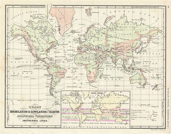
Chart of the Highlands & Lowlands of the Earth Principal Volcanoes and Isothermal Lines.
1866 (undated) 9 x 11.5 in (22.86 x 29.21 cm)
1866 (undated) 9 x 11.5 in (22.86 x 29.21 cm)
Description
This is a beautiful example of Francis McNally's 1866 map of world, featuring the highlands and lowlands of the earth, important volcanoes and the world's isothermal lines. An inset near the bottom features a wind chart. The map is color coded and marks various mountain ranges, peaks, volcanoes, table lands, plains, deserts, and several other topographical details. Continents are named but boundaries of countries are not shown. This map was issued as map no. 1 in McNally's System of Geography.
Cartographer
Rand, McNally and Co. (fl. 1856 - present) is an American publisher of maps, atlases and globes. The company was founded in 1856 when William H. Rand, a native of Quincy, Massachusetts, opened a print shop in Chicago. Rand hired the recent Irish immigrant Andrew McNally to assist in the shop giving him a wage of 9 USD per week. The duo landed several important contracts, including the Tribune's (later renamed the Chicago Tribune) printing operation. In 1872, Rand McNally produced its first map, a railroad guide, using a new cost effective printing technique known as wax process engraving. As Chicago developed as a railway hub, the Rand firm, now incorporated as Rand McNally, began producing a wide array of railroad maps and guides. Over time, the firm expanded into atlases, globes, educational material, and general literature. By embracing the wax engraving process, Rand McNally was able to dominate the map and atlas market, pushing more traditional American lithographic publishers like Colton, Johnson, and Mitchell out of business. Eventually Rand McNally opened an annex office in New York City headed by Caleb S. Hammond, whose name is today synonymous with maps and atlases, and who later started his own map company, C. S. Hammond & Co. Both firms remain in business. More by this mapmaker...
Source
McNally, F., An Improved System of Geography, 1866.
Condition
Very good. Text on verso.