This item has been sold, but you can get on the Waitlist to be notified if another example becomes available, or purchase a digital scan.
1866 Mitchell Map of the World in Hemispheres
WorldInHemispheres-mitchell-1866$100.00

Title
The World in Hemispheres. With Other Projections etc. etc.
1860 (dated) 12 x 13.5 in (30.48 x 34.29 cm) 1 : 140000000
1860 (dated) 12 x 13.5 in (30.48 x 34.29 cm) 1 : 140000000
Description
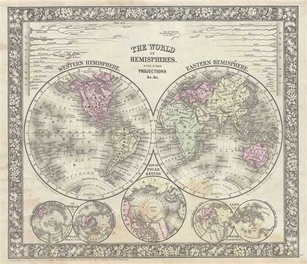
This is a beautiful example of S. A. Mitchell Jr.'s 1866 decorative double hemisphere map of the world. Depicts the world on a hemisphere projection. The upper part of the map shows the rivers in relative proximity while the lower half features three additional world maps, a hemisphere map on a polar projection, a land and water hemisphere projection, and one of the northern Polar Regions. Countries are named but boundaries are not defined. The map notes important rivers, cities, islands, mountains and other features and is color coded according to continents with elevation rendered by hachure.
One of the most attractive American atlas maps of this region to appear in the mid-19th century. Prepared by S. A. Mitchell Jr. for inclusion as plate 1 in the 1866 issue of Mitchell's New General Atlas. Like many American map publishers of this period, Mitchell did not regularly update his copyright, consequently this map is dated and copyrighted to 1860: 'Entered according to Act of Congress in the Year 1860 by S. Augustus Mitchell Jr. in the Clerks Office of the District Court of the U.S. for the Eastern District of Pennsylvania.'
One of the most attractive American atlas maps of this region to appear in the mid-19th century. Prepared by S. A. Mitchell Jr. for inclusion as plate 1 in the 1866 issue of Mitchell's New General Atlas. Like many American map publishers of this period, Mitchell did not regularly update his copyright, consequently this map is dated and copyrighted to 1860: 'Entered according to Act of Congress in the Year 1860 by S. Augustus Mitchell Jr. in the Clerks Office of the District Court of the U.S. for the Eastern District of Pennsylvania.'
Cartographer
Samuel Augustus Mitchell (March 20, 1792 - December 20, 1868) began his map publishing career in the early 1830s. Mitchell was born in Bristol, Connecticut. He relocated to Philadelphia in 1821. Having worked as a school teacher and a geographical writer, Mitchell was frustrated with the low quality and inaccuracy of school texts of the period. His first maps were an attempt to rectify this problem. In the next 20 years Mitchell would become the most prominent American map publisher of the mid-19th century. Mitchell worked with prominent engravers J. H. Young, H. S. Tanner, and H. N. Burroughs before attaining the full copyright on his maps in 1847. In 1849 Mitchell either partnered with or sold his plates to Thomas, Cowperthwait and Company who continued to publish the Mitchell's Universal Atlas. By about 1856 most of the Mitchell plates and copyrights were acquired by Charles Desilver who continued to publish the maps, many with modified borders and color schemes, until Mitchell's son, Samuel Augustus Mitchell Junior, entered the picture. In 1859, S.A. Mitchell Jr. purchased most of the plates back from Desilver and introduced his own floral motif border. From 1860 on, he published his own editions of the New General Atlas. The younger Mitchell became as prominent as his father, publishing maps and atlases until 1887, when most of the copyrights were again sold and the Mitchell firm closed its doors for the final time. More by this mapmaker...
Source
Mitchell Jr., S. A., Mitchell's New General Atlas, Containing Maps Of The Various Countries Of The World, Plans Of Cities, Etc. Embraced In Forty-Seven Quarto Maps, Forming A Series Of Seventy-Six Maps And Plans, Together With Valuable Statistical Tables, 1866 edition.
Condition
Very good. Some foxing at places.
References
Rumsey 2483.001 (1870 Edition). Phillips (Atlases) 831-16. New York Public Library, Map Division 1510790.