This item has been sold, but you can get on the Waitlist to be notified if another example becomes available, or purchase a digital scan.
1858 Johnson Map of the World's Magnetic Curves
WorldMagnetic-johnson-1858$37.50

Title
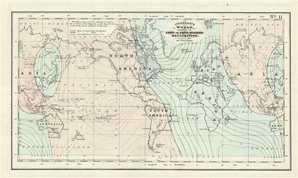
Johnson's World, Showing the Lines of Equal Magnetic Declination.
1858 (dated) 6 x 10.5 in (15.24 x 26.67 cm)
1858 (dated) 6 x 10.5 in (15.24 x 26.67 cm)
Description
This is a beautiful example of Johnson's 1858 map or chart of the world's magnetic curves of equal variation. The chart depicts the magnetic curves over the entire world including the isomagnetic lines over every continent. It marks the North Magnetic Pole at the Boothia Felix (now the Boothia Peninsula) based on the first expedition by James Clark Ross in 1831. Due to the magnetic changes in the earth's core, the position of the magnetic poles change over time. In 2005, it was estimated that the North Magnetic Pole was positioned to the west of ellesmere Island in Canada. Johnson based this map on th work of Arnold Henry Guyot, an influential Swiss-American geologist.
CartographerS
Alvin Jewett Johnson (September 23, 1827 - April 22, 1884) was a prolific American map publisher active from 1856 to the mid-1880s. Johnson was born into a poor family in Wallingford, Vermont, where he received only a basic public education. He is known to have worked as a school teacher for several years before moving to Richmond, Virginia. Johnson got his first taste of the map business as a salesman and book canvasser for J. H. Colton. The earliest Johnson maps were published with D. Griffing Johnson (no clear relation) and date to the mid-1850s; however, it was not until 1860 that the Johnson firm published its first significant work, the Johnson's New Illustrated (Steel Plate) Family Atlas. The publication of the Family Atlas followed a somewhat mysterious 1859 deal with the well-established but financially strapped J. H. Colton cartographic publishing firm. Although map historian Water Ristow speculates that Colton sold his copyrights to Johnson and his business partner, another Vermonter named Ross C. Browning (1822 - 1899), a more likely theory is that Johnson and Browning financially supported the Colton firm in exchange for the right to use Colton's existing copyrighted map plates. Regardless of which scenario actually occurred, it is indisputable that the first Johnson atlas maps were essentially reissues of earlier Colton maps. Early on, Johnson described his firm as the 'Successors to J. H. Colton and Company'. Johnson's business strategy involved transferring the original Colton steel plate engravings to cheaper lithographic stones, allowing his firm to produce more maps at a lower price point. In 1861, following the outbreak of the American Civil War (1861 - 1865) Johnson and Browning split their firm between two offices. Johnson moved from Richmond, Virginia, to New York City. Browning remained in Richmond, where he published at least one more edition of the atlas in 1862, at the height of the war. Johnson and Browning published two editions of the Johnson Atlas: 1860 (Richmond and New York) and 1861 (Richmond and New York). Sometime in 1861, Browning's portion of the firm (or perhaps the New York portion?) was purchased by Benjamin P. Ward, whose name subsequently replaced Browning's on the imprint. The 1863 issue of the Family Atlas was one of the most unusual, it being a compilation of older 'Johnson and Browning' maps, updated 1862 'Johnson and Ward' maps, and newer 1863 maps with a revised border design. The 1864 issue of the Family Atlas is the first fully 'Johnson and Ward' atlas. Johnson published one more edition of the atlas in partnership with Ward in 1865, after which Johnson bought out Ward. The next issue of the atlas, 1866, is the first purely 'Johnson' atlas with all new map plates, updated imprints, and copyrights. The Family Atlas went through roughly 27 years of publication, from 1860 to 1887, outliving Johnson himself, who died in 1884. Johnson maps from the Family Atlas are notable for their unique borders, of which there are four different designs, the 'strapwork border' from 1860 to 1863, the 'fretwork border' from 1863 to 1869, the 'spirograph border' in 1870 to 1882, and a more elaborate version of the same from 1880 to 1887. In addition to the Family Atlas, Johnson issued numerous wall maps, pocket maps, and in the 1880s, the Cyclopedia. Johnson maps are known for their size, accuracy, detail, and stunning, vivid hand coloring. Johnson's maps, purely American in their style and execution, chronicle some of the most important periods in American history, including the Civil War, the Westward Expansion, and the Indian Wars. Today Johnson's maps, especially those of the American West, are highly sought after by map collectors and historians. More by this mapmaker...
Arnold Henry Guyot (September 28, 1807 - February 8, 1884) was a Swiss-American geologist and geographer. Though he intended to join the ministry, during his education he became familiar with the natural sciences, working with close friend Louis Agassiz and forming a connection with von Humboldt. At Agassiz’ urging he studied glaciers in the Swiss Alps, and presented to the Geological Society of France what would be the first important data on glacial motion. He became professor of history and geography at the College of Neuchâtel. On its closing, he emigrated to the United States with his mother, sister and nephew, the draftsman Ernest Sandoz. There he would become a lecturer, first at the Lowell Institute, and later as a professor of geography and geology at Princeton. During his professorship he worked for the Smithsonian Institution in order to develop a national meteorological system, which would result in the formation of the United States Weather Bureau. He was accompanied in his emigration by his produced a number of text books, as well as a series of educational wall maps. Guyot produced maps in conjunction with his nephew from about 1857 to 1881. His work with Sandoz included the first detailed maps of the Catskills and the Southern Appalachians. Learn More...
Condition
Very good. Blank on verso.