This item has been sold, but you can get on the Waitlist to be notified if another example becomes available, or purchase a digital scan.
1840 Black Map of the World on Mercator's Projection
WorldMercator-black-1840$100.00

Title
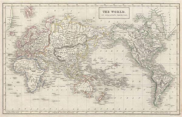
The World, on Mercator's Projection.
1840 (undated) 10.5 x 16.5 in (26.67 x 41.91 cm)
1840 (undated) 10.5 x 16.5 in (26.67 x 41.91 cm)
Description
A fine example of Adam and Charles Black's 1840 map of the world on Mercator's Projection. An interesting map of the world issued just as most of the earth's non-polar shore has been explored. Gone are many of the errors of the previous century with the coastlines of the Arctic, the American Northwest, Australia, and New Zealand accurately rendered. Inland though, much remained confused. Vast stretches of unmapped territory and speculative cartography fill central Asia, South America, the western United States, Africa and Australia. This map was engraved by G. Aikman for issue in the 1840 edition of Black's General Atlas.
Cartographer
Charles and Adam Black (fl. 1807 - present) were map and book publishers based in Edinburgh. Charles and his uncle, Adam, both of Edinburgh, Scotland, founded their publishing firm in 1807. They published a series of maps and atlases throughout the 19th century. In addition to an array of atlases, the Black firm is known for their editions of the Encyclopedia Britannica (1817 - 1826) and the first publishing of Sir Walter Scott's novels in 1854. In 1889 the A. & C. Black publishing house moved to London where it remains in operation to this day. More by this mapmaker...
Source
Hall, Sydney, Black's General Atlas: A series of Fifty-Four Maps from the Latest and Most Authentic Sources, Engraved on Steel, In the First Style of the Art, (Edinburgh: Adam and Charles Black) 1840.
Condition
Very good condition. Blank on verso.
References
Rumsey 2305.003 (1854 edition). Philips (atlases) 4334.