This item has been sold, but you can get on the Waitlist to be notified if another example becomes available, or purchase a digital scan.
1825 Tanner World Map on Mercator's Projection
WorldMercator-tanner-1825$475.00

Title
The World on Mercator's Projection.
1825 (undated) 19 x 22 in (48.26 x 55.88 cm) 1 : 80000000
1825 (undated) 19 x 22 in (48.26 x 55.88 cm) 1 : 80000000
Description
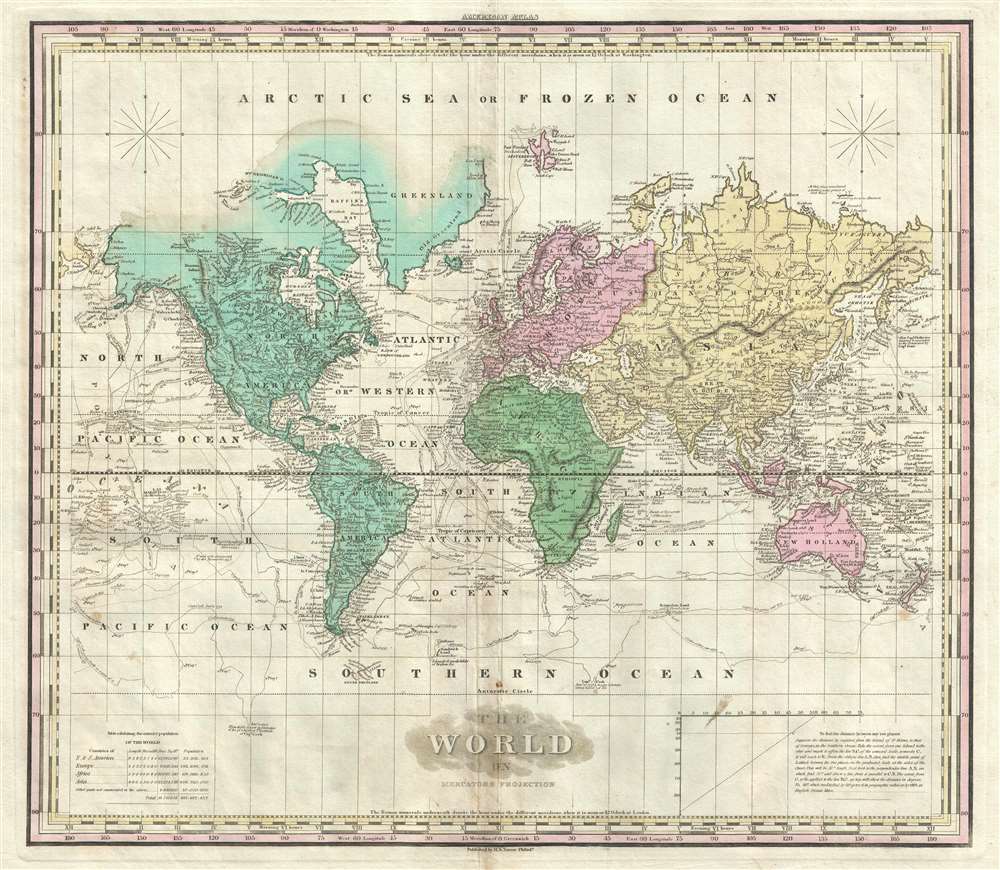
This is an 1825 Henry Shenk Tanner world map on Mercator's projection. The map depicts six of the seven continents, excluding Antarctica, although the Antarctic Circle is noted. Curiously, the only continent not to be illustrated in its entirety is North America, with its northern coastline simply blending into the 'Arctic Sea or Frozen Ocean' as it is labeled. The northern coastline of Greenland is also missing, which demonstrates that Arctic exploration, though beginning, has not explored every corner of the globe up to this point. However, the northern coast of Russia is depicted fully, which is intriguing, since it was not until 1878 that an explorer managed to round the most northern extremes of Asia by ship.
Myriad cities are labeled on the map, including New York, Boston, Washington D.C., Havana (Havanna), Veracruz, London, Paris, Madrid and too many others to list. The routes taken by 18th century explorers are depicted, including those of Captains Cook, Vancouver, and Perouse. Numerous rivers are labeled, such as the Yangtze, Mississippi, and Amazon.
This map was created and published by Henry Shenk Tanner for the 1825 edition of his A New American Atlas.
Cartographer
Henry Schenck Tanner (1786 - May 18, 1858) was one of the preeminent American map engravers and publishers of the early 19th century - what is considered to be the "Golden Age of American Map Publishing". Born in New York City but based in Philadelphia, Tanner's forty plus year career was almost entirely focused on cartographic work. His earliest map work appears in conjunction with another important map publisher, John Melish. Early in his career, Tanner partnered with his brother Benjamin, to engrave extensively for Melish as well as other Philadelphia publishers including Lucas Fielding (Baltimore), A. Bourne, Jason Torey, Samuel Harrison, and Samuel Lewis, among others. In 1818 Tanner convinced his fellow publishers and partners to finance the compilation of a New American Atlas. The atlas was sold by subscription and slowly emerged between 1819 and 1823. The New American Atlas, possibly the pinnacle of 19th century American cartography and was commended in its day as "one of the most splendid works of the kind ever executed in this country". It was subsequently republished in several updated editions until about 1839. Tanner had by this time become the most active and influential map publisher in the United States. Around 1832, recognizing the market for a less cost prohibitive atlas, Tanner began work on the smaller format New Universal Atlas. This popular and important atlas went through numerous editions before being bought out by Carey and Hart, and then, in 1846, by S. A. Mitchell, who would rise to become the preeminent publisher of the next generation. In addition to these important atlases, Tanner also issued numerous extremely important and influential travelers guides, state maps, wall maps, and pocket maps. He should not be confused with his brother, also an America map engraver, the New Yorker Benjamin Tanner. More by this mapmaker...
Source
Tanner, H. S., A New American Atlas, (Philadelphia: Tanner) 1825.
Condition
Very good. Even overall toning. Light soiling. Blank on verso.
References
Rumsey 2755.001. OCLC 57239417.