This item has been sold, but you can get on the Waitlist to be notified if another example becomes available, or purchase a digital scan.
1918 Japanese Propaganda Map of World War I and Russo-Japanaese War
WWICommMap-armyeductional-1918$1,750.00

Title
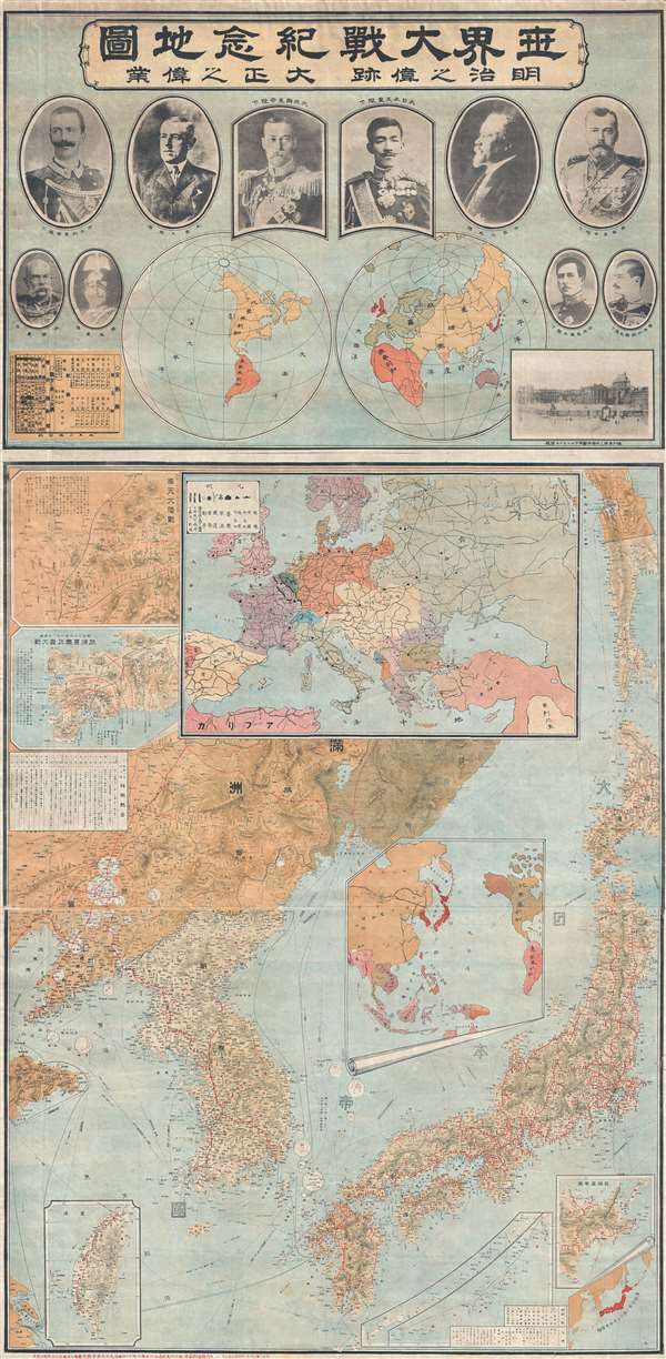
世界大戰紀念地圖 明治之偉跡 大正之偉業 / Commemorative Map of the World War. The Great Footprint of Meiji, the Great Undertaking of Taisho.
1918 (dated) 62 x 30 in (157.48 x 76.2 cm)
1918 (dated) 62 x 30 in (157.48 x 76.2 cm)
Description
A rare, exceptional, and impressively proportioned 1919 Taishō 8 Japanese propaganda map prepared to celebrate Japanese achievements in World War I (Jul 28, 1914 - Nov 11, 1918) and the Russo-Japanese War (Feb 8, 1904 - Sep 5, 1905). During the course of these two wars, a period of less than 20 years, Japan fulfilled the ambitions of the Emperor Meiji, and his successor Taishō, transforming itself from a backward and isolated nation into an industrial and military power writ large on the world stage.
The Leaders of World War I
The map is divided into two major sections, the upper section illustrating he world theater with portraits of the major wartime leaders. An illustration of Versailles, where the treaty concluding the war would be signed, appears in the lower right corner of the upper map. The portraits, from top left illustrate King Victor Emmanuel III (Italy), Woodrow Wilson (United States), King George V (England), the Emperor Taishō (Japan), Raymond Poincaré (France), Tsar Nicholas II (Russia), Franz Joseph I (Austria), Emperor Wilhelm II (Germany), King Alexander I (Yugoslavia), and King Peter I (Serbia).
Japan Becomes a Major Regional Power
The lower part of the map illustrates the East Asian theater during the two wars. The focus is the Empire of Japan, including Korea and Taiwan, and wartime activity primarily in the vicinity of Manchuria, Liaodong Peninsula, and Shandong Peninsula, China. Although Japan was a minor player in World War I, with action primarily confined to East Asia, it participation in the war rapidly elevated it to a major world power. As the title suggests, the war fulfilled the great Meiji dream of reimagining Japan as a modern industrial power. Japan served as an Allied supply house throughout the war, leading to a booming wartime economy. At the same time, it leveraged its participation in the war to seize control of German colonies in China, particularly Qingdao.
Meiji Dream, Taisho Achievement
Several map insets also focus on important Japanese conquests during the Russo-Japanese War (Feb 8, 1904 - Sep 5, 1905) including the two-week long Battle of Mukden (Feb 20, 1905 - March 10, 1905) and the Battle of Port Arthur (Feb 8 - 9, 1904), both important Japanese victories. That the Japanese compiler of this map linked the events of the Russo-Japanese War, during which Russia and Japan were at odds, with the events of World War I, when they were allies, expresses the idea that Japan did not necessarily consider itself as part of the greater global hostilities, rather that both wars were merely tools in Japan's ascent as a world power.
This map was quite rare, but we are aware of at least one other edition published in 1914. That example his housed in this Nanjing Massacre Memorial Hall, in Nanjing, China. No further examples are known. The publisher of the map is unclear but it may have been issued by the educational and propaganda branch of the Japanese military.
Condition
Very good. Older Japanese tissue backing.