This item has been sold, but you can get on the Waitlist to be notified if another example becomes available, or purchase a digital scan.
1919 Clason Guide Map of Wyoming
Wyoming-clason-1919$175.00

Title
Clason's Guide Map of Wyoming.
1919 (dated) 16 x 19.5 in (40.64 x 49.53 cm) 1 : 1280000
1919 (dated) 16 x 19.5 in (40.64 x 49.53 cm) 1 : 1280000
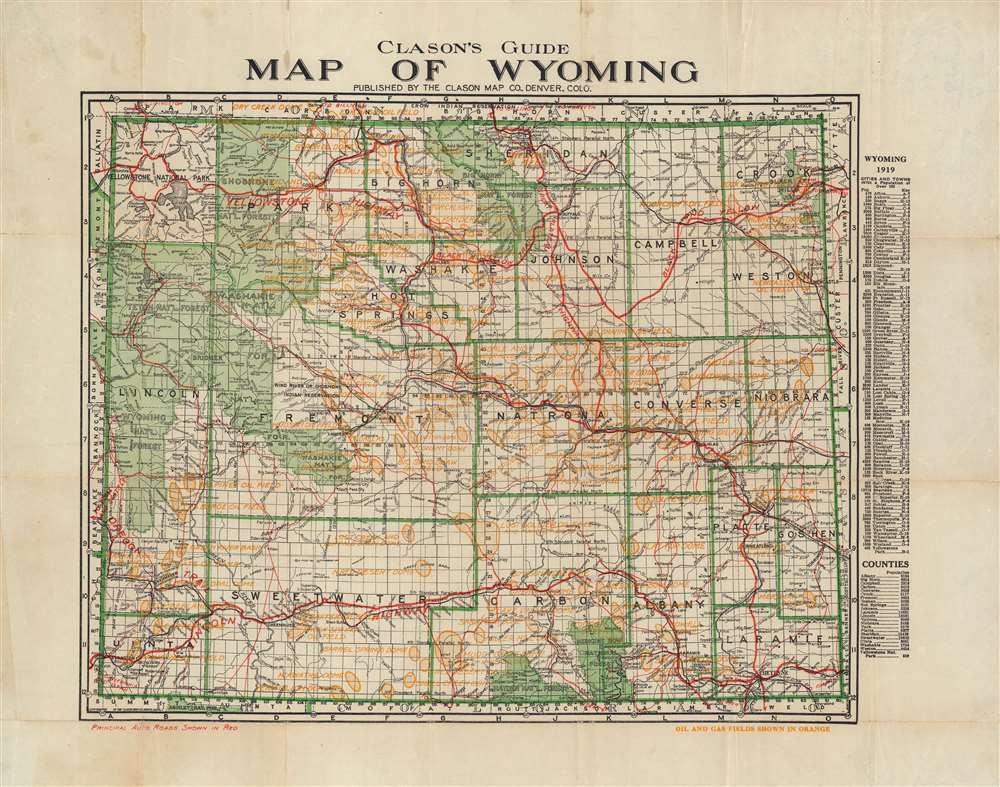
Description
An uncommon 1920 pocket map of Wyoming, by George Clason. The map covers the entire state of Wyoming including Yellowstone National Park, and the surrounding Teton National Forest, Wyoming National Forest, Washakie National Forest, and Shoshone National Forest. The map is divided into its counties; these, and cities and towns are named on a list to the right of the map with coordinates keyed to the map itself. The list includes the population numbers for each named place. Automobile roads throughout the map are marked in red; oil and gas fields are also indicated in orange.
Publication History and Census
The map was printed by Denver's Clason Map Company, with its first edition in 1911. The map was regularly updated and stayed in print as late as 1930. We see three examples of this 1919 edition catalogued in institutional collections, at Ohio State University, the University of Utah, Yale University, and the Huntington.Cartographer
George Samuel Clason (November 7, 1874 - 1957) was born in the city of Louisiana, Missouri in 1874. As a young man, Clason studied at the University of Nebraska before joining the United States Army in 1898 to fight in the Spanish American War. After the war, he moved to Denver, Colorado where in 1905 he founded the Clason Map Company, thus starting his lucrative publishing career. Clason initially focused on mining and mineral maps - capitalizing on the Colorado and Nevada mining industry, but quickly transitioned to railroad maps, city maps, and by the 1920s, road maps. As the company expanded, Clason opened a secondary office in Chicago, Illinois - then a rising map publishing center and railroad hub. At least one other satellite office was opened in Los Angeles. Among his many achievements, Clason is credited with producing the first modern road atlas of the United States. In the late 1920s, Clason also published a series of get-rich-quick pamphlets in the form of parables. The most famous of these is The Richest Man in Babylon. This tells the story of Arkad, a citizen of Babylon famed for his great wealth and generosity who shares his wit and wisdom with his fellow Babylonians. In 1949, Clason moved to Napa, California to retire and found a social club for retired gentlemen. More by this mapmaker...
Condition
Very good. Reinforced areas of wear at junctures of folds.
References
Rumsey 4060.003 (1917).