This item has been sold, but you can get on the Waitlist to be notified if another example becomes available, or purchase a digital scan.
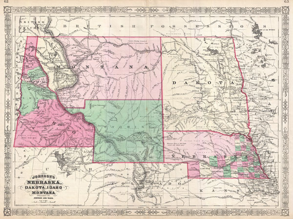
1866 Johnson Map of Montana, Wyoming, Idaho, Nebraska and Dakota
WyomingMontanaIdaho-johnson-1866
Title
1866 (dated 1865) 18 x in (45.72 x 0 cm)
Description
This is also the first Johnson map to incorporate Wyoming - which is absent from the 1865 edition of this map. Note that, though Wyoming is demarked as a territory, the lettering of the territorial title is in a light outline typeface - a sharp contrast to the bold titles for Montana, Dakota, and Idaho. This is due to the fact that though the territory of Wyoming had been proposed by Representative J. M. Ashley of Ohio in 1865, it was considered a temporary measure. The region was not officially incorporated as a territory until 1868. This early configuration of the territory also truncates the border with Montana at 44.5 degrees north latitude, giving Wyoming a curious ephemeral western panhandle.
Within Montana the western portions beyond the Rocky Mountains, are highlighted and identified as Missoula. In 1865 this region had only recently been settled by traders and missionaries. Nonetheless, by 1866 it has become a stopping point for the Mullans Wagon Road, which is also identified.
Throughout this map Johnson offers spectacular detail identifying explorers routes, mines, American Indian Nations, springs, forts, mountain passes, and an assortment of additional geographical and political elements. In particular he identifies all three proposed routes for the Pacific Railroad, the Emigrant Road, gold deposits in Montana and Idaho, Pike's Peak, Fremont's Peak, and Yellowstone Lake.
Though copyrighted to 1865, this map was updated by Johnson for publication as plate nos. 62-63 in the 1866 edition of his New Illustrated Atlas… This is the last edition of the Johnson's Atlas to bear the Johnson and Ward imprint and the first to include Wyoming.
Cartographer
Alvin Jewett Johnson (September 23, 1827 - April 22, 1884) was a prolific American map publisher active from 1856 to the mid-1880s. Johnson was born into a poor family in Wallingford, Vermont, where he received only a basic public education. He is known to have worked as a school teacher for several years before moving to Richmond, Virginia. Johnson got his first taste of the map business as a salesman and book canvasser for J. H. Colton. The earliest Johnson maps were published with D. Griffing Johnson (no clear relation) and date to the mid-1850s; however, it was not until 1860 that the Johnson firm published its first significant work, the Johnson's New Illustrated (Steel Plate) Family Atlas. The publication of the Family Atlas followed a somewhat mysterious 1859 deal with the well-established but financially strapped J. H. Colton cartographic publishing firm. Although map historian Water Ristow speculates that Colton sold his copyrights to Johnson and his business partner, another Vermonter named Ross C. Browning (1822 - 1899), a more likely theory is that Johnson and Browning financially supported the Colton firm in exchange for the right to use Colton's existing copyrighted map plates. Regardless of which scenario actually occurred, it is indisputable that the first Johnson atlas maps were essentially reissues of earlier Colton maps. Early on, Johnson described his firm as the 'Successors to J. H. Colton and Company'. Johnson's business strategy involved transferring the original Colton steel plate engravings to cheaper lithographic stones, allowing his firm to produce more maps at a lower price point. In 1861, following the outbreak of the American Civil War (1861 - 1865) Johnson and Browning split their firm between two offices. Johnson moved from Richmond, Virginia, to New York City. Browning remained in Richmond, where he published at least one more edition of the atlas in 1862, at the height of the war. Johnson and Browning published two editions of the Johnson Atlas: 1860 (Richmond and New York) and 1861 (Richmond and New York). Sometime in 1861, Browning's portion of the firm (or perhaps the New York portion?) was purchased by Benjamin P. Ward, whose name subsequently replaced Browning's on the imprint. The 1863 issue of the Family Atlas was one of the most unusual, it being a compilation of older 'Johnson and Browning' maps, updated 1862 'Johnson and Ward' maps, and newer 1863 maps with a revised border design. The 1864 issue of the Family Atlas is the first fully 'Johnson and Ward' atlas. Johnson published one more edition of the atlas in partnership with Ward in 1865, after which Johnson bought out Ward. The next issue of the atlas, 1866, is the first purely 'Johnson' atlas with all new map plates, updated imprints, and copyrights. The Family Atlas went through roughly 27 years of publication, from 1860 to 1887, outliving Johnson himself, who died in 1884. Johnson maps from the Family Atlas are notable for their unique borders, of which there are four different designs, the 'strapwork border' from 1860 to 1863, the 'fretwork border' from 1863 to 1869, the 'spirograph border' in 1870 to 1882, and a more elaborate version of the same from 1880 to 1887. In addition to the Family Atlas, Johnson issued numerous wall maps, pocket maps, and in the 1880s, the Cyclopedia. Johnson maps are known for their size, accuracy, detail, and stunning, vivid hand coloring. Johnson's maps, purely American in their style and execution, chronicle some of the most important periods in American history, including the Civil War, the Westward Expansion, and the Indian Wars. Today Johnson's maps, especially those of the American West, are highly sought after by map collectors and historians. More by this mapmaker...
Source
Server Error
Page Not Found
This page either doesn't exist, or it moved somewhere else.
That's what you can do

