1944 MacMillan World War II Pictorial Route Map of Western Europe (France, Belgium, Holland)
XIXCorpsInAction-macmillan-1944$325.00

Title
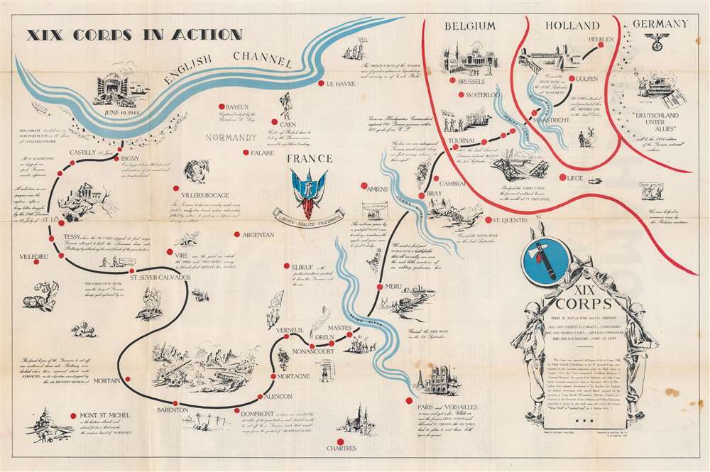
XIX Corps in Action.
1944 (dated) 17.5 x 27 in (44.45 x 68.58 cm)
1944 (dated) 17.5 x 27 in (44.45 x 68.58 cm)
Description
This is a 1944 World War II route map of parts of France, Belgium, Holland, and Germany. It is the first of two maps by Henry J. MacMillan illustrated to follow the 'XIX Corps in Action'. Among similar 'route maps, it holds the distinction of being the only such printed during the war, in November 1944.
A Closer Look
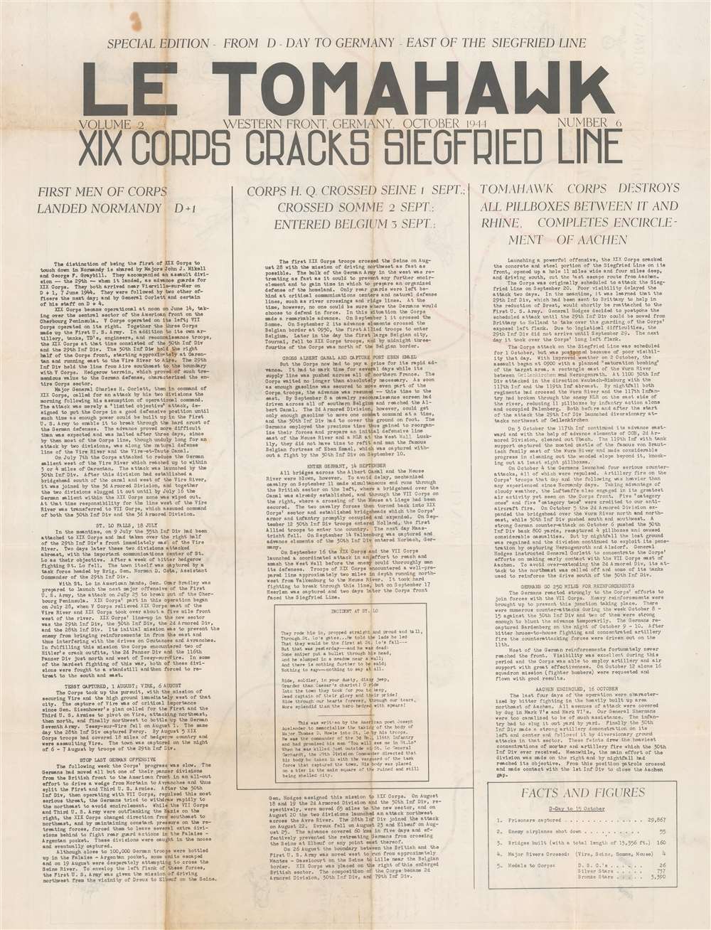
MacMillan’s map exhibits the best elements of the genre: wonderful vignettes, commentary on events, and humorous content. This combination offers unique insight into the wartime experience. Among the events included here are the liberation of St. Lo, France, and the corps’ bypassing of Paris. It's even possible to trace the creation of some of the vignettes (such as the destroyed 'Palais de Justice' marking St. Lo) to MacMillan's wartime paintings. (Some have been digitized by the Cape Fear Museum.) The title cartouche, flanked by two soldiers at attention, also provides a short history of the corps from its organization until its October 1944 encounter with the Siegfried Line.Verso Content: Le Tomahawk
Le Tomahawk was created by Major Ray Craft as a newsletter for the XIX Corps (at that time the 29th and 30th Infantry Divisions and the 2nd and 3rd Armored Divisions). Craft, a newsman from California, served as an aid to Major General Charles H. Corlett, the commanding general of the XIX Corps. (From Pogue's War: Diaries of a WWII Combat Historian by Forrest C. Pogue, pp. 130 - 31). This newsletter, and others like them, served news to frontline soldiers, including events more or less in real time.World War II Route Maps
Maps tracing unit movements during World War II were created by both American and British forces both during and after the war. As a genre, these maps represent a broad range of aesthetics, from the purely functional that label places and provide dates, to the artistic, even comic. Many combine the three and provide a visually striking but historically informative summary of the unit's peregrinations.Engineer Topographic Battalions during World War II
After World War II erupted in Europe, U.S. military officials realized that currently available maps of Europe were inadequate for modern artillery units or even tactical purposes. Their solution was the creation of engineer topographic battalions. Engineer Topographic Battalions provided technical support for the U.S. Army in the form of surveying, drafting, and printing maps for units on the ground. During the war, these battalions were responsible for creating accurate four-color topographic maps, along with surveying, printing, and distribution of these maps.Publication History and Census
This map was drawn by Henry Jay MacMillan and printed by the 62nd Engineer Topographic Company in November 1944. We note four examples cataloged in OCLC which are part of the collections at the Library of Congress, the National Defense University, the Wisconsin Veterans Museum Research Center, and the University of Memphis. An example is also part of the David Rumsey Map Collection and Persuasive Maps: PJ Mode Collection at Cornell University.Cartographer
Henry Jay MacMillan (January 13, 1908 - December 29, 1991) was an American artist. Born in Wilmington, North Carolina, MacMillan was a well-known, formally trained artist in Wilmington when he was drafted into the U.S. Army in 1942. He served in the 62nd Engineer Topographic Company attached to the XIXth Corps and created watercolor paintings of the war in France (Normandy), Belgium, and Germany. These included scenes of river crossings, bombed buildings, and troop movements. He was discharged in 1945 and resumed his art career in North Carolina. The Cape Fear Museum, to which he donated his wartime artwork in the 1970s, exhibited this work in an exhibition entitled WWII: A Local Artist's Perspective from May 15, 2014 - April 26, 2015. More by this mapmaker...
Condition
Very good. Wear along original fold lines. Text 'Le Tomahawk. XIX Corps Cracks Siegfried Line' on verso.
References
Cornell University, Persuasive Maps: PJ Mode Collection, 1320. Rumsey 9865.002. OCLC 22496240, 775545534.