
Baker, Joseph
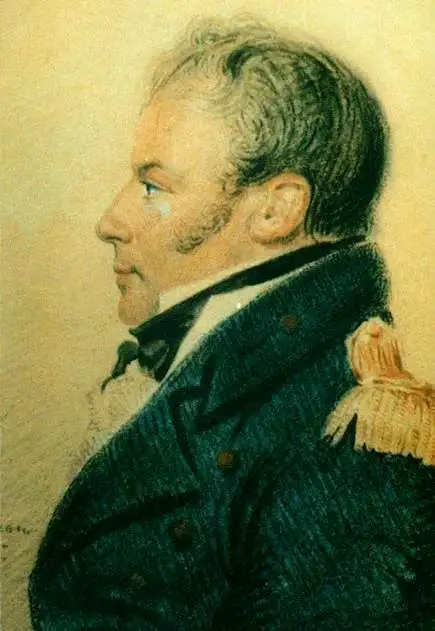
Joseph Baker (1767 - 1817) was a British naval officer and explorer best known for his service under George Vancouver during the historical Vancouver expedition to map the Pacific Northwest. Vancouver was born in the Welsh border counties. He joined the Royal Navy in 1787 where he met and befriended then-Lieutenant George Vancouver and then-Midshipman Peter Puget. When Vancouver was commissioned to complete the exploration of the American Northwest Coast, he chose Baker as he 3rd Lieutenant and Puget as his 2nd Lieutenant. During the course of the expedition Baker was assigned the task of converting surveys into working maps and his name appears on many of Vancouver's most important maps, including the first complete map of the Hawaiian Islands. Baker, along with the expedition's naturalist Archibald Menzies, completed the first recorded ascent of Hawaii's Mauna Loa volcano. Mt. Baker, in modern day Washington, is also named after him. In his journals Vancouver wrote admiringly of Baker's work:
…my third Lieutenant Mr. Baker had undertaken to copy and embellish, and who, in point of accuracy, neatness, and such dispatch as circumstances admitted, certainly excelled in a very high degree.Following the Vancouver expedition Baker briefly retired from naval service until being recalled and made Captain in 1808. Assigned to the ship HMS Tartar, Baker was charged with escort duty in the Baltic. There, in a series of skirmishes with Danish privateers, Baker fell afoul of his British superiors and was court-martialed. Although acquitted of the court martial, Baker never again served in the Royal Navy. He retired to Presteigne where he maintained a long standing friendship to Puget, who moved to the same town on his own retirement.
You can't see it from space, but you can see it here.
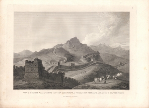
View of the Great Wall of China, called Van-Lee-Tching, or Wall of Ten Thousand Lee taken near the Pass of Cou-Pe-Koo.
$500.00
Acquire
- Digital Map Information
- Suitable for large format printing
- Full resolution TIFF file
- ICC color profile embedded
- Delivered instantly via download link
An intricately engraved view of the Great Wall of China drawn by William Alexander based on a sketch by Henry William Parish and engraved by Thomas Medland for inclusion in George Leonard Staunton's An Authentic Account of an Embassy from the King of Great Britain to the Emperor of China. This view was important in developing the aura of the Great Wall in the Western imagination of China, but it also reveals how the wall had become unimportant in China itself. (more details)
Lovely place to summer.
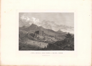
A view of Poo-Ta-La or Great Temple near Zhe-Hol in Tartary.
$400.00
Acquire
- Digital Map Information
- Suitable for large format printing
- Full resolution TIFF file
- ICC color profile embedded
- Delivered instantly via download link
An impressive view of the Putuo Zongcheng Temple drawn by William Alexander based on a sketch by Henry William Parish and engraved by Benjamin Pouncy for inclusion in George Leonard Staunton's An Authentic Account of an Embassy from the King of Great Britain to the Emperor of China. It depicts the Putuo Zongcheng Temple (普陀宗乘之庙) at Rehe (here as Zhe-hol, now Chengde), the Qing summer palace where the British Macartney embassy met with the Qianlong Emperor in 1793. (more details)
A Maladroit Meeting between Britain and China.
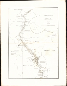
A sketch of a journey from Zhe-Hol in Tartary by land to Pekin and from thence by water to Hang-Tchoo-Foo in China.
$375.00
Acquire
- Digital Map Information
- Suitable for large format printing
- File Size: 13.55 MB
- File Type: ZIP / TIFF
- ICC color profile embedded
- Delivered instantly via download link
This important 1796 John Barrow map of China traces the course of the British Macartney Mission after its unsuccessful meeting with the Qing Emperor Qianlong. As a diplomatic effort, the embassy failed completely, the result of mutual misunderstanding and mistrust between the Qing Court and the British. But, as this map demonstrates, the mission did allow the British to gain a much better direct understanding China's geography (more details)
A lovely palace, before it was burned and looted.
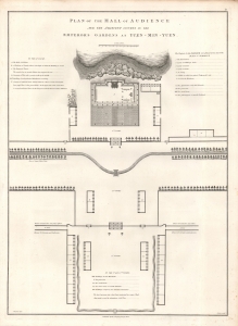
Plan of the Hall of Audience and the Adjacent Courts in the Emperor's Gardens at Yuen-Min-Yuen.
$250.00
Acquire
- Digital Map Information
- Suitable for large format printing
- DPI: 600
- File Size: 10.99 MB
- File Type: ZIP / TIFF
- ICC color profile embedded
- Delivered instantly via download link
A lovely example of Sir John Barrow's 1796 schematic of the main audience hall of the Yuanmingyuan or 'Old Summer Palace,' an impressive complex of palaces and gardens built for the Qing emperors just outside of Beijing. It appeared in George Leonard Staunton's An Authentic Account of an Embassy from the King of Great Britain to the Emperor of China, recounting the Macartney Embassy, a failed British attempt to gain expanded trading and diplomatic rights in China. (more details)
Largest, most beautiful, and most important early map of Hawaii.

Carte des Iles Sandwich d'apres la reconnoissance qui en a ete faite dans les differentes relaches de la corvette La Decouverte et de sa conserve Le Chatham commandes par le Capt. Vancouver en 1792, 1793 et 1794.
$5,000.00
Acquire
- Digital Map Information
- Suitable for large format printing
- Full resolution TIFF file
- ICC color profile embedded
- Delivered instantly via download link
This is a beautiful example of George Vancouver's seminal 1799 map of the Hawaiian Islands, considered the largest, most important, and most beautiful map of Hawaii to appear in the 18th century. (more details)