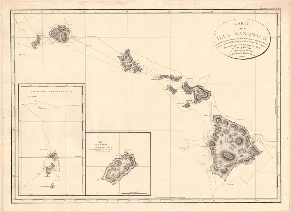
1799 Vancouver Map of Hawaii
Hawaii-vancouver-1799-3$5,000.00

Title
Carte des Iles Sandwich d'apres la reconnoissance qui en a ete faite dans les differentes relaches de la corvette La Decouverte et de sa conserve Le Chatham commandes par le Capt. Vancouver en 1792, 1793 et 1794.
1799 (undated) 22 x 31 in (55.88 x 78.74 cm) 1 : 860000
1799 (undated) 22 x 31 in (55.88 x 78.74 cm) 1 : 860000
Description
This is a beautiful example of George Vancouver's seminal 1799 map of the Hawaiian Islands, considered the largest, most important, and most beautiful map of Hawaii to appear in the 18th century.
A Closer Look
George Vancouver first sighted Hawaii on January 18, 1778, as a midshipman on the HMS Discovery, consort ship to Captain James Cook's HMS Resolution. As such, Vancouver was one of the first Europeans to see the idyllic island group. Despite Cook being killed by angry Hawaiian natives, Vancouver formed a good opinion of both the archipelago and the Hawaiian people. Fourteen years later, leading his own historic voyage of exploration, George Vancouver chose the Hawaiian Islands as a winter base while searching the Northwest Coast of America for the elusive Northwest Passage. During his three seasonal visits to the Hawaiian Islands, Vancouver and his lieutenant, Joseph Baker, completed this, the first complete map of the archipelago. His route, which zigzags around and between the islands, is carefully noted and includes visits in 1792, 1793, and 1794.Close Ties with Hawaii
Unlike many explorers, Vancouver maintained excellent relations with the indigenous peoples of Hawaii, introduced useful plants and animals to the islands, made important anthropological observations, and allegedly even negotiated a 1794 cession of the archipelago to Great Britain. Vancouver's extraordinary mapping of the Hawaiian Islands was the most advanced cartographic picture of the archipelago to appear until the late 19th century, when the Hawaiian government issued its own national surveys.Insets: The Galapagos and Cocos Islands
In the lower left, inset maps detail parts of the Galapagos and Cocos Islands. Although not the first accurate charting of the Galapagos Islands - that honor goes to the 1798 Arrowsmith - this is among the earliest acquirable charts to focus on the remote archipelago. Cocos Island appears on maps from the 17th century, although Vancouver's is unusually detailed, showing anchorages and interior topography.Publication History and Census
This particular example of Vancouver's map was issued in the highly desirable 1799 French edition of Vancouver's atlas, which is noted for being more beautifully produced with better engraving, higher quality paper, and more detail than the 1798 English edition. Despite its importance, this piece is scarce. The OCLC places original imprints of this edition in only the British Library, UCLA, UNC-Chapel Hill, and the National Library of Australia. The entire Voyage de Decouvertes appears only at the University of Quebec at Montreal, the Bibliothèque Geneve, and the Bibliothèque Publique et Univ. Neuchatel. We find auction and catalog records for only six examples since 1997.CartographerS
George Vancouver (June 22, 1750 - May 10, 1798) was a British naval officer and explorer active in the late 18th century. Vancouver was the last of the great naval explores of the 18th century and, along with Captain James Cook and Perouse, is credited with the first accurate mapping of the Northwest Coast of America. Vancouver was born in King's Lynn, England and joined the Royal Navy at age 13 as a seaman. While little is known of Vancouver's early life, he first appears in the annals of history as a midshipmen aboard the HMS Resolution of Captain Cook's second voyage in search of Terra Australis. On this expedition Vancouver claimed to have "been nearer the south pole than any other man" (after climbing the bowsprit before the ship turned back in the face of mountains of Antarctic ice). He also accompanied the third Cook expedition as a midshipman on the HMS Discovery where he witnessed the discovery of the Hawaiian Islands as well as Cooks tragic death on those same islands. Returning to England under Cook's second, Captain Clerke recommended Vancouver for promotion to Lieutenant. Under his new commission he spent several years learning surveying in the Caribbean aboard the HMS Martin, where he also distinguished himself in a number of military altercations with the French. In 1790 Vancouver received an appointment as the Captain of the HMS Discovery and was commissioned to complete the exploration of American's Northwest Coast begun by Cook and Perouse. Between 1791 and 1795 Vancouver's remarkable diligence and attention to detail created the first truly accurate cartographic picture of the American Coast between San Francisco Bay and California. Vancouver was the first to map countless rivers and inlets and to identify Vancouver Island. During his four years of exploration he also spent three winters in Hawaii, creating in the process the first accurate map of the islands. Unlike many earlier explorers Vancouver generally maintained good and respectful relations with the indigenous peoples he encountered. In Hawaii Vancouver allegedly negotiated the cession of Hawaii to England as well as introduced beneficial flora and fauna to the archipelago. Vancouver returned to England in 1795 where he immediately ran afoul of the powers that be. During his voyages Vancouver excited the ire of more than one crew member, including the well-connected naturalist Archibald Menzies, the sailing master Joseph Whidbey, and Thomas Pitt, the powerful Baron of Camelford. Slandered and assaulted by these influential enemies, one of Britian's greatest explorers fell into obscurity. He died shortly after in 1798 and was buried in an unremarkable grave at St. Peter's Churchyard, Petersham, Surrey, England. The journals of Vancouver's expedition, as well as his all-important maps, were published posthumously in the same year as his death. Robin Fisher, the academic Vice President of Mount Royal University in Calgary and author of two books on Vancouver, writes: He [Vancouver] put the northwest coast on the map...He drew up a map of the north-west coast that was accurate to the 'nth degree,' to the point it was still being used into the modern day as a navigational aid. That's unusual for a map from that early a time.
Today Vancouver is memorialized by Vancouver Island, which he discovered, the Hudson Bay Company's Fort Vancouver, the city of Vancouver, Vancouver Peninsula Australia, Mount Vancouver, the 8th highest mountain in Canada, Vancouver Bay in Jervis Inlet, and the Vancouver Maritime Museum. For his 250th birthday, the Canada Post issued a special postage stamp in his honor. More by this mapmaker...
Joseph Baker (1767 - 1817) was a British naval officer and explorer best known for his service under George Vancouver during the historical Vancouver expedition to map the Pacific Northwest. Vancouver was born in the Welsh border counties. He joined the Royal Navy in 1787 where he met and befriended then-Lieutenant George Vancouver and then-Midshipman Peter Puget. When Vancouver was commissioned to complete the exploration of the American Northwest Coast, he chose Baker as he 3rd Lieutenant and Puget as his 2nd Lieutenant. During the course of the expedition Baker was assigned the task of converting surveys into working maps and his name appears on many of Vancouver's most important maps, including the first complete map of the Hawaiian Islands. Baker, along with the expedition's naturalist Archibald Menzies, completed the first recorded ascent of Hawaii's Mauna Loa volcano. Mt. Baker, in modern day Washington, is also named after him. In his journals Vancouver wrote admiringly of Baker's work:…my third Lieutenant Mr. Baker had undertaken to copy and embellish, and who, in point of accuracy, neatness, and such dispatch as circumstances admitted, certainly excelled in a very high degree.
Following the Vancouver expedition Baker briefly retired from naval service until being recalled and made Captain in 1808. Assigned to the ship HMS Tartar, Baker was charged with escort duty in the Baltic. There, in a series of skirmishes with Danish privateers, Baker fell afoul of his British superiors and was court-martialed. Although acquitted of the court martial, Baker never again served in the Royal Navy. He retired to Presteigne where he maintained a long standing friendship to Puget, who moved to the same town on his own retirement. Learn More...
Source
Baker, J., and G. Vancouver, Voyage de decouvertes a l'ocean Pacifique du Nord, et autour du monde, (Paris: Imprimerie de la République) 1799.
Condition
Very good. Slight foxing.
References
OCLC 225249938. National Library of Australia, MAP RM 581. Fitzpatrick, G. L., The Early Mapping of Hawai'I, pl. 21 (English edition). Phillips 197. Sabin, J., Biblioteca Americana. A Dictionary of Books Relating to America, from its Discovery to Present TIme, (29 vols) 98443. Wagner, H. R., The Cartography of the Northwest Coast of America to the Year 1800 (2 vols), 853-860. Rumsey 3354.015 (English Edition).