
This item below is out of stock, but another example (left) is available. To view the available item, click "Details."
Details
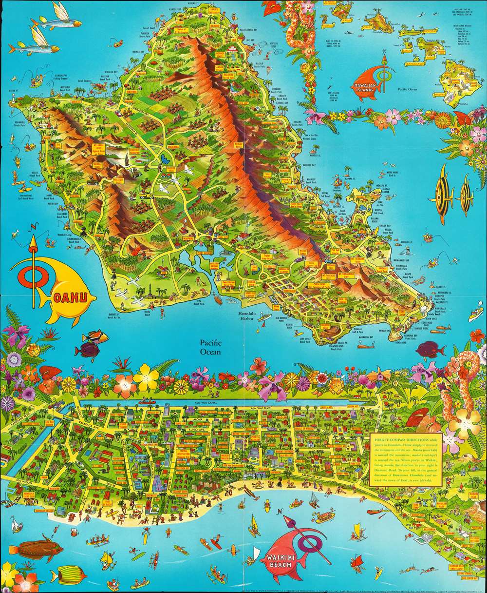
1956 Bloodgood Pictorial Map of Oahu and Waikiki Beach, Hawaii
$225.00
1956 Bloodgood Pictorial Map of Oahu and Waikiki Beach, Hawaii
OahuWaikiki-bloodgood-1956$112.50

Title
A Pic Tour Map Honolulu - Waikiki and 'Round the Isle of OAHU.
1956 (dated) 21.75 x 18 in (55.245 x 45.72 cm)
1956 (dated) 21.75 x 18 in (55.245 x 45.72 cm)
Description
This is a 1956 Don Bloodgood pictorial map of the island of Oahu and Waikiki Beach. Created in two sections, the map of Oahu depicts the entire island and occupies nearly two thirds of the printed area. Sites all across the island, from Kaena Point to Makapuu Point and from Kahuku Point to Diamond Head are identified. These range from cities and towns, such as Honolulu, Lanikai, and Waialee, to coastal beaches, including Waikiki, and other important sites, such as Pearl Harbor, the Battleship Arizona Memorial, and the Mormon Temple. Palm groves and pineapple plantations dot the landscape, while surfers and fisherman ply the waters just off shore. Fish and whales are illustrated around the island. An inset of all eight Hawaiian Islands is located in the upper right corner and labels each of the islands. Mauna Loa, Mauna Kea, Kilauea, and Haulalai are illustrated and labeled on the island of Hawaii, as is Mt. Waialeale, the wettest spot in the world, on Kauai. Distances from Honolulu to the other islands is given, as are distances between Honolulu and Australia, New Zealand, Tokyo, Manila, Portland, San Francisco, and Los Angeles.
The wonderfully comical map of Honolulu and Waikiki is situated along the bottom third of the sheet and depicts the city from Kapiolani Boulevard to Diamond Head and from the Ala Wai Canal to Waikiki Beach. Buildings throughout the city are illustrated in profile, including hotels, apartment buildings, the zoo, and the band stand in Kapiolani Park. Beachgoers are shown partaking in different activities, such as surfing, snorkeling, sailing, sunbathing, and simply enjoying a day out at the beach.
The wonderfully comical map of Honolulu and Waikiki is situated along the bottom third of the sheet and depicts the city from Kapiolani Boulevard to Diamond Head and from the Ala Wai Canal to Waikiki Beach. Buildings throughout the city are illustrated in profile, including hotels, apartment buildings, the zoo, and the band stand in Kapiolani Park. Beachgoers are shown partaking in different activities, such as surfing, snorkeling, sailing, sunbathing, and simply enjoying a day out at the beach.
Publication History and Census
This map was drawn by Don Bloodgood and published by Ray Helbig's Hawaiian Service in 1956.Cartographer
Donald Newman Bloodgood (October 21, 1896/7 - February 6, 1989), known as 'Don', was an American illustrator, map maker, and cartoonist active in the middle part of the 20th century. Born in California, he relocated to Sedona, Arizona, in 1960. Bloodgood produced a large corpus of pictorial maps between 1935 and 1968, most for either Shell Oil or the Pic-Tour guide series. His first known map is the illustration of San Diego drawn for the California Pacific International Exposition in 1935. Much of Bloodgood's work was produced in conjunction with Shell Oil. His work is considered stylistically similar to that of Jo Mora. More by this mapmaker...
Condition
Good. Wear slight loss along original fold lines. Verso repairs to fold separations. Text and printed photographs on verso.