
This item below is out of stock, but another example (left) is available. To view the available item, click "Details."
Details
1960 First Edition Bloodgood Pictorial Map of the Navajo Nation in Arizona
1960 (dated) $400.00
1968 Bloodgood Pictorial Map of the Navajo Nation in Arizona
Navajoland2-bloodgood-1968$100.00

Title
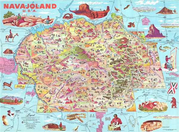
Navajoland U.S.A.
1968 (dated) 20.5 x 27.675 in (52.07 x 70.2945 cm) 1 : 601920
1968 (dated) 20.5 x 27.675 in (52.07 x 70.2945 cm) 1 : 601920
Description
This is the 1968 edition of Don Bloodgood's pictorial map of the Navajo Nation. The map was published for the Navajo Tribal Council to strengthen tribal identity, both internally and externally, in the face of compounded external pressure relating to the discovery of rich mineral deposits on Navajo lands, and internal crises due to poor infrastructure and endemic poverty. The map, a celebration of Navajo land and culture, was distributed for free nationally, where it drew attention to tribal causes.
A Closer Look
The map depicts northeastern Arizona, southeastern Utah, southwestern Colorado, and northwestern New Mexico from Grand Canyon National Park to Chaco Canyon National Monument and from Cortez and Durango, Colorado to Holbrook and Sedona, Arizona. Beautifully colored and meticulously drawn, myriad locations throughout the tribal lands are illustrated and labeled. Trading posts, parks, Navajo National Monuments, and coal and uranium mines are among the labeled sites. Several towns, such as Shiprock, Tuba City, Leupp, and Oak Springs are also labeled. Several Navajo rug weaving areas are also noted by a symbol of a partially woven rug on a loom. The Four Corners, where Colorado, New Mexico, Arizona, and Utah all meet is also highlighted. Outside the Navajo Nation, Mesa Verde National Park, Grand Canyon National Park, Sunset Crater National Monument and Petrified Forest National Park are all illustrated in pink, to make them easily recognizable against the blue used to color non-tribal areas. Vignettes surround the Navajo Nation, illustrating scenes of Navajo life, along with numerous scenic vistas.Historical Context
The Navajo Nation is second-largest federally recognized tribe in the U.S., with a semi-autonomous territory occupying some 28,000 square miles incorporating portions of Colorado, New Mexico, Arizona, and Utah. As this map went to the presses, in 1960, the Navajo faced an identity crisis brought on by the collision of ancient traditions and 20th century demands, and compounded by lack of infrastructure, poverty, inadequate educational opportunities, and endemic alcoholism. Amidst the broader backdrop of the Civil Rights Movement, the Navajo were additionally grappling with land rights and access to resources. The decade saw continued disputes with federal and state governments over territory. The Navajo's traditional economy, largely based on herding and weaving, was collapsing due to climate change, overgrazing, land encroachment. At the same time, the discovery of valuable minerals like oil, gas, and uranium on Navajo land presented a double-edged sword: while these resources held the promise of economic revitalization, their extraction came at significant social, environmental, and cultural costs. In response, the Navajo Tribal Council began a series of initiatives to assert Navajo tribal identity, underscoring their territory, culture, and history as a distinct but important part of the American quilt.Publication History and Census
This map was created by Don Bloodgood and first published by the Navajo Tribal Council in 1960. At the time the map was offered free by mail or could be picked up in person at Navajo tribal offices. There are at least two subsequent editions, likely more. This is the second edition, published in 1968.Cartographer
Donald Newman Bloodgood (October 21, 1896/7 - February 6, 1989), known as 'Don', was an American illustrator, map maker, and cartoonist active in the middle part of the 20th century. Born in California, he relocated to Sedona, Arizona, in 1960. Bloodgood produced a large corpus of pictorial maps between 1935 and 1968, most for either Shell Oil or the Pic-Tour guide series. His first known map is the illustration of San Diego drawn for the California Pacific International Exposition in 1935. Much of Bloodgood's work was produced in conjunction with Shell Oil. His work is considered stylistically similar to that of Jo Mora. More by this mapmaker...
Condition
Very good. Unusual bubbling on right side. Text and photographs on verso.
References
Rumsey 8665.003. OCLC 866418409.