
Bollmann, Herman

Herman Bollmann (1911 - 1971) was a German cartographer and map maker active from roughly 1940 to 1970. Before World War II, Bollmann was a well-known woodcarver and engraver based in Braunschweig, Germany. Following the war, Bollmann developed a reputation as a printer of unique three-dimensional maps. Working over a period of 25 years, Bollmann established a reputation as an artistic cartographer, producing over 39 unique projections of various cities in Europe and America. Bollmann revived the 19th-century cartographic technique known as Vogelschaukarten, a way of making three-dimensional axonometric projections. Bollmann and his team relied heavily on aerial cartography to compose distinctive cartographic masterpieces that are coveted by collectors all over the world.
Billionaire's Row When It Was Still Cool.
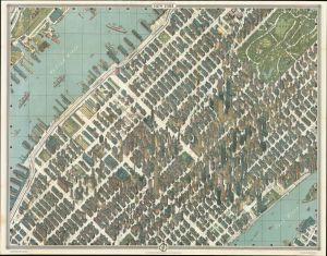
The pinnacle of urban cartographic art - this is the 1962 Bollmann axonometric map of midtown Manhattan, in its first issue. This distinctive view presents the heart of New York City at the stylistic peak of the skyscraper era: over half of the world's skyscrapers standing at the time appear within the bounds of this view. (more details)
Stunning pictorial map of Jerusalem.
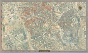
This is a 1969 first-edition example of Herman Bollmann's large-format bird's-eye view of Jerusalem, accompanied by its original promotional marketing material and order sheet from Wim van Leer Publications. Bringing the Old City, the commercial center, and the western university and government district into a single architectural panorama, it presents a city whose political and physical geography had just changed profoundly due to Israel's capture of East Jerusalem during the Six-Day War. (more details)