
1969 Bollman Bird's Eye View Pictorial Map of Jerusalem

Jerusalem.
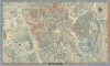
Stunning pictorial map of Jerusalem.
Stunning pictorial map of Jerusalem.
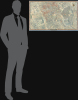
This is a 1969 first-edition example of Herman Bollmann's large-format bird's-eye view of Jerusalem, accompanied by its original promotional marketing material and order sheet from Wim van Leer Publications. Bringing the Old City, the commercial center, and the western university and government district into a single architectural panorama, it presents a city whose political and physical geography had just changed profoundly due to Israel's capture of East Jerusalem during the Six-Day War.A Closer Look
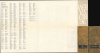
The view extends from the Hebrew University's Givat Ram campus and the Israel Museum in the west to the Old City, Kidron Valley, and slopes of the Mount of Olives in the east. Romema and its industrial district occupy the upper left, while the railway station, Mount Zion, and Silwan appear toward the bottom. Rather than concentrating exclusively on the holy places (as he did in another contemporary map also titled 'Jerusalem' but focusing exclusively on the old city), Bollmann integrates them into a working city of residential neighborhoods, hospitals, schools, government offices, transport facilities, and commercial premises.The Old City's Jewish, Christian, Muslim, and Armenian Quarters are labeled, together with its gates and principal monuments. The Dome of the Rock and Al-Aqsa Mosque occupy the open platform of the Haram al-Sharif / Temple Mount; farther west, the Church of the Holy Sepulcher and the tall tower of the Church of the Redeemer rise above the surrounding rooftops. Outside the walls, the Church of the Tomb of the Virgin, Gethsemane, David's Tomb, the Church of the Dormition, and the Yemin Moshe synagogue extend the religious geography across the valleys and neighboring hills. Cemeteries, terraces, orchards, and individually drawn trees make those intervening landscapes unusually legible. The orange ornamental border carries Jerusalem's name in sixteen languages, interspersed with the letters and numbers of a reference grid. On the verso, an alphabetical street index appears, along with glossaries explaining Hebrew street terminology.
A particularly consequential detail is the open space before the Western Wall, labeled here as the Wailing Wall. This records, though does not explicitly reference, the city's altered landscape following the demolition of the Mughrabi neighborhood in 1967 to create the prayer plaza. The neighborhood was quickly razed in the days after the Six-Day War at the behest of West Jerusalem Mayor Teddy Kollek (who wrote a preface and added his signature to the booklet accompanying the map). Despite this inauspicious start, Kollek was pragmatic in relations with the city's Arab population and even considered pro-Arab by some hardline Zionist Israelis. In any event, Kollek's long tenure (28 years) as Mayor of Jerusalem, lasting until 1993, saw extensive development along the edges of the existing city and its population more than double, when including East Jerusalem (administered as part of the Jerusalem Municipality but of an indeterminate legal status under domestic and international law).
A Commission Born of the Six-Day War
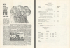
The accompanying promotional material reproduces an article titled 'New Map Shows Every House in the Capital,' which supplies an account of the project's origins. Wim van Leer (1913 - 1992), a Haifa industrialist and film producer, had admired a pictorial map of Amsterdam produced for KLM. According to Hazleton, the events of June 1967 turned that admiration into a commission: van Leer wanted a personal contribution to what he considered Jerusalem's reunification and traveled to Germany to engage Bollmann, already well known for constructing axonometric city views from photographic documentation. The article reports that the Jerusalem project drew on 187,000 aerial and ground photographs and twelve months of work by seven draftsmen. Special cameras recorded the city from street level and from the air, supplying details of windows, balconies, roofs, and facades that were later translated into the drawing.Publication History
This map was published in several different editions and states, all of which were created by Herman Bollmann, who was commissioned by Wim van Leer. The present example was published in Haifa, Israel, by Wim van Leer in 1969. A smaller, vertically oriented map with the same title details only the Old City and was printed both in gold and with more conventional ink (see our Jerusalem-bollmann-1969). Every edition bears the same copyright information, indicating that they were created and published simultaneously. A second edition of the present map was published in 1972, but it is not easily distinguishable from the first edition and still bears the date 1969 around the compass rose at top-right. These facts make it difficult to distinguish catalog listings clearly, particularly when dimensions are not included.Cartographers
Herman Bollmann (1911 - 1971) was a German cartographer and map maker active from roughly 1940 to 1970. Before World War II, Bollmann was a well-known woodcarver and engraver based in Braunschweig, Germany. Following the war, Bollmann developed a reputation as a printer of unique three-dimensional maps. Working over a period of 25 years, Bollmann established a reputation as an artistic cartographer, producing over 39 unique projections of various cities in Europe and America. Bollmann revived the 19th-century cartographic technique known as Vogelschaukarten, a way of making three-dimensional axonometric projections. Bollmann and his team relied heavily on aerial cartography to compose distinctive cartographic masterpieces that are coveted by collectors all over the world. Further Details...
Wim van Leer (1913 - April 14, 1992) was a Dutch-Israeli industrialist and philanthropist. Van Leer served in Britain's Royal Air Force during World War II as a pilot and, after immigrating to Israel, served in the Israeli Air Force as well. He was best known for establishing Israel's first film archive, the Jerusalem Cinematheque. The Van Leer Institute was endowed by his family and promotes Arabe-Jewish dialogue. Van Leer married Lia Greenberg (August 8, 1924 - March 13, 2015) in Haifa in 1952. Further Details...
Condition
Excellent. Attached to original binder.
References
OCLC 5567634 (co-mingles multiple maps and editions with same title).